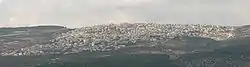
Ein Mahil
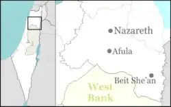
Ein Mahil (Arabic: عين ماهل; Hebrew: עֵין מָהִל) is an Arab local council in the Northern District of Israel, located about five kilometers north-east of Nazareth. It was declared a local council in 1964. In 2019 it had a population of 13,335,[1] the majority of which are Muslims.
Ein Mahil
| |
|---|---|
Local council (from 1964) | |
| Hebrew transcription(s) | |
| • ISO 259 | ʕein Máhel |
 | |
 Ein Mahil  Ein Mahil | |
| Coordinates: 32°43′23″N 35°21′08″E | |
| Grid position | 183/236 PAL |
| Country | |
| District | Northern |
| Area | |
| • Total | 5,203 dunams (5.203 km2 or 2.009 sq mi) |
| Population (2019)[1] | |
| • Total | 13,335 |
| • Density | 2,600/km2 (6,600/sq mi) |
| Name meaning | "The spring of the barren land."[2] |
History
Ottoman Empire
In 1596, Ein Mahil appeared in Ottoman tax registers as being in the Nahiya of Tabariyya, part of Safad Sanjak. It had a population of 28 Muslim households. They paid a fixed tax rate of 20% on agricultural products, which included wheat, barley, fruit trees, and goats or beehives; a total of 1,355 akçe.[3] A map by Pierre Jacotin, from 1799 showed the place named Ain el Mahel.[4]
In 1838 it was noted as a Muslim village in the Nazareth district.[5][6]
The French explorer Victor Guérin passed by the village in the 1875, and described it as having 10 poor dwellings, surrounded by gardens of olives, figs and pomegranates.[7] In 1881 the PEF's Survey of Western Palestine (SWP) described it as a "Stone village, situated on very high ground, surrounded by figs and olives and arable land. It contains about 200 Moslems, and has near it a fine group of springs."[8]
A population list from about 1887 showed that ’Ain Mahil had about 195 Muslim inhabitants.[9]
British Mandate
In the 1922 census of Palestine conducted by the British Mandate authorities, 'Ain Mahel had a population of 516, all Muslims.[10] The population increased in the 1931 census of Palestine to 628, of whom 1 was Christian and the rest Muslims, in a total of 109 occupied houses.[11]
In the 1945 statistics the population was 1,040 Muslims,[12] with 13,390 dunams of land, according to an official land and population survey.[13] Of this, 1,486 dunams were for plantations and irrigable land, 6,748 for cereals,[14] while 35 dunams were built-up land.[15]
See also
References
- "Population in the Localities 2019" (XLS). Israel Central Bureau of Statistics. Retrieved 16 August 2020.
- Palmer, 1881, p. 122
- Hütteroth and Abdulfattah, 1977, p. 189
- Karmon, 1960, p. 167
- Robinson and Smith, 1841, vol 3, 2nd appendix, p. 132
- Robinson and Smith, 1841, vol 3, p. 209
- Guérin, 1880, p. 382
- Conder and Kitchener, 1881, SWP I, p. 362
- Schumacher, 1888, p. 184
- Barron, 1923, Table XI, Sub-district of Nazareth, p. 38
- Mills, 1932, p.73
- Department of Statistics, 1945, p. 8
- Government of Palestine, Department of Statistics. Village Statistics, April, 1945. Quoted in Hadawi, 1970, p. 62
- Government of Palestine, Department of Statistics. Village Statistics, April, 1945. Quoted in Hadawi, 1970, p. 109
- Government of Palestine, Department of Statistics. Village Statistics, April, 1945. Quoted in Hadawi, 1970, p. 159
Bibliography
- Barron, J.B., ed. (1923). Palestine: Report and General Abstracts of the Census of 1922. Government of Palestine.
- Conder, C.R.; Kitchener, H.H. (1881). The Survey of Western Palestine: Memoirs of the Topography, Orography, Hydrography, and Archaeology. 1. London: Committee of the Palestine Exploration Fund.
- Department of Statistics (1945). Village Statistics, April, 1945. Government of Palestine.
- Grootkerk, Salomon E. (2000). Ancient sites in Galilee: a toponymic gazetteer (Illustrated ed.). BRILL. ISBN 90-04-11535-8. (p. 292)
- Guérin, V. (1880). Description Géographique Historique et Archéologique de la Palestine (in French). 3: Galilee, pt. 1. Paris: L'Imprimerie Nationale.
- Karmon, Y. (1960). "An Analysis of Jacotin's Map of Palestine" (PDF). Israel Exploration Journal. 10 (3, 4): 155–173, 244–253.
- Hadawi, S. (1970). "Village Statistics of 1945: A Classification of Land and Area ownership in Palestine". Palestine Liberation Organization Research Center. Cite journal requires
|journal=(help) - Hütteroth, Wolf-Dieter; Abdulfattah, Kamal (1977). Historical Geography of Palestine, Transjordan and Southern Syria in the Late 16th Century. Erlanger Geographische Arbeiten, Sonderband 5. Erlangen, Germany: Vorstand der Fränkischen Geographischen Gesellschaft. ISBN 3-920405-41-2.
- Mills, E., ed. (1932). Census of Palestine 1931. Population of Villages, Towns and Administrative Areas. Jerusalem: Government of Palestine.
- Palmer, E.H. (1881). The Survey of Western Palestine: Arabic and English Name Lists Collected During the Survey by Lieutenants Conder and Kitchener, R. E. Transliterated and Explained by E.H. Palmer. Committee of the Palestine Exploration Fund.
- Rhode, H. (1979). Administration and Population of the Sancak of Safed in the Sixteenth Century. Columbia University.
- Robinson, E.; Smith, E. (1841). Biblical Researches in Palestine, Mount Sinai and Arabia Petraea: A Journal of Travels in the year 1838. 3. Boston: Crocker & Brewster.
- Schumacher, G. (1888). "Population list of the Liwa of Akka". Quarterly statement - Palestine Exploration Fund. 20: 169–191.
External links
- Welcome To 'Ayn Mahil
- Survey of Western Palestine, Map 6: IAA, Wikimedia commons
.svg.png.webp)
