Carson National Forest
Carson National Forest is a national forest in northern New Mexico, United States. It encompasses 6,070 square kilometers (1.5 million acres) and is administered by the United States Forest Service. The Forest Service's "mixed use" policy allows for its use for recreation, grazing, and resource extraction.
| Carson National Forest | |
|---|---|
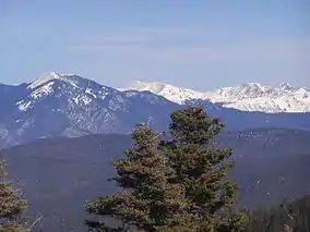 Sangre de Cristo Mountains in Carson National Forest | |
 | |
| Location | New Mexico, United States |
| Nearest city | Taos, NM |
| Coordinates | 36.517222°N 106.066944°W |
| Area | 1,391,674 acres (5,631.90 km2)[1] |
| Established | July 1, 1908[2] |
| Governing body | U.S. Forest Service |
| Website | Carson National Forest |
Geography
Wheeler Peak, the highest mountain in New Mexico at 13,161 feet (4,011 m), is located in the National Forest.
The forest is located mainly in Rio Arriba (63.4% of acreage) and Taos (34.65%) counties, but smaller areas extend eastward into western Mora and Colfax counties.[3]
Wildlife
Big game animals roam this forest. They include mule deer, elk, pronghorn, black bears, coyotes, bobcats, foxes, cougars, and bighorn sheep. There are also many species of smaller mammals and songbirds. Forest personnel work closely with the State Game and Fish Department to provide the best wildlife habitat possible. Carson has four hundred miles of sparkling clean mountain streams and numerous lakes. Many of them are stocked with native trout by the Game and Fish Department.
History
The forest was once inhabited by the Ancestral Pueblo people, who left ruins of adobe dwellings and other artifacts at an archaeological site now called Pot Creek Cultural Site. Some areas of the forest were formerly lands granted to settlers by the Spanish monarchy and the Mexican government. After the Mexican–American War, the national forest was established, and was named for American pioneer Kit Carson.
Carson National Forest was established with the merger of Taos National Forest and part of Jemez National Forest on July 1, 1908.[4]
Included in the merged lands was the land surrounding Blue Lake, an important cultural, religious site to the Tao Indians. In the early 20th century, the Taos Indians petitioned the federal government to regain Blue Lake, but their requests were denied. Attempts to prevent Taos ceremonies at Blue Lake were included in the government's attempts to assimilate Indigenous peoples into mainstream settler culture. The Department of Agriculture therefore denied requests to set aside land at Blue Lake for the Taos Indians to perform ceremonies, claiming that it was "foreign to the policies of the Department of Agriculture, when once some land has been set aside as a National Forest, to allow it to be withdrawn completely and donated to a private purpose."
In 1965, the Association on American Indian Affairs published a booklet called The Blue Lake Appeal in order to garner support for requests to return Blue Lake through the Indian Claims Commission (ICC). The ICC then concluded that the Taos Indians' land had been illegally obtained and no proper amends had been made to rectify it, suggesting a monetary award as compensation. The Taos Indians refused a monetary settlement, leading to a deliberation in Congress to return Blue Lake back to the tribe. When the bill was deadlocked in Congress, the Taos Pueblo brought their case to President Richard Nixon, who pushed their request through Congress in 1970, returning the Blue Lake to Taos Pueblo.[5]
In October 1966, the Alianza Federal de Mercedes, an organization dedicated to the restoration of certain land grants entrenched in the 1848 Treaty of Guadalupe Hidalgo to descendants of then-Mexican citizens, occupied the Carson Forest's Echo Amphitheater in an attempt to create a land grant community.[6] The occupants were evicted, after five days, for overstaying camping permits. In 1982, the forest grew by 405 square kilometers (100,000 acres) when the Pennzoil corporation donated the Valle Vidal Unit to the American people.
Wilderness areas
Within the Carson National Forest are five designated and one proposed wilderness areas. Two of these are located mostly in neighboring Santa Fe National Forest (as indicated).
- Chama River Canyon Wilderness (mostly in Santa Fe NF)
- Columbine-Hondo Wilderness
- Cruces Basin Wilderness
- Latir Peak Wilderness
- Pecos Wilderness (mostly in Santa Fe NF)
- Wheeler Peak Wilderness
Forest service
Forest headquarters are located in Taos, New Mexico. There are local ranger district offices in Bloomfield, Canjilon, El Rito, Penasco, Questa, and Tres Piedras.[3]
Gallery
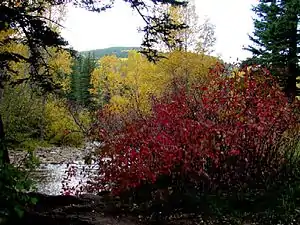 Fall colors near Tres Piedras, in the Carson National Forest
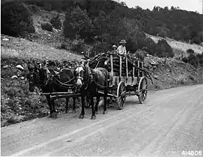 Wood hauler along the Rio Pueblo, 1941. An average rural family here would use about 20 loads like this per year for fuel wood
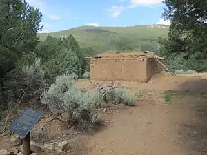 Pot Creek Cultural Site, in Carson Nation Forest, south of Taos
References
- "Land Areas of the National Forest System" (PDF). U.S. Forest Service. January 2012. Retrieved June 26, 2012.
- "The National Forests of the United States" (PDF). Forest History Society. Retrieved November 2, 2017.
- USFS Ranger Districts by State
- Davis, Richard C. (September 29, 2005), National Forests of the United States (PDF), Forest History Society, archived from the original (pdf) on 2013-02-12
- Catton, Theodore (2016). American Indians and National Forests. Tucson: The University of Arizona Press. pp. 95–102. ISBN 9780816536511.
- Nabokov, Peter (October 1966). "Echo Amphitheater (1)". Peter Nabokov Collection, 1967-1968. University of New Mexico. Retrieved 2019-01-25.
External links
- Carson National Forest - US Forest Service