Bloomingdale, New Jersey
Bloomingdale is a borough in Passaic County, New Jersey, United States. As of the 2010 United States Census, the borough's population was 7,656,[11][12] reflecting an increase of 46 (+0.6%) from the 7,610 counted in the 2000 Census, which had in turn increased by 80 (+1.1%) from the 7,530 counted in the 1990 Census.[22]
Bloomingdale, New Jersey | |
|---|---|
| Borough of Bloomingdale | |
 | |
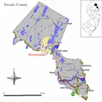 Map of Bloomingdale in Passaic County. Inset: Location of Passaic County highlighted in the State of New Jersey. | |
 Census Bureau map of Bloomingdale, New Jersey | |
| Coordinates: 41.03526°N 74.333737°W[1][2] | |
| Country | |
| State | |
| County | |
| Incorporated | February 23, 1918 |
| Government | |
| • Type | Borough |
| • Body | Borough Council |
| • Mayor | Vacant, following death of Jonathan Dunleavy (D, term ending December 31, 2022)[4][5][6] |
| • Administrator | Vacant[7][8] |
| • Municipal clerk | Breeanna Calabro[9] |
| Area | |
| • Total | 9.25 sq mi (23.95 km2) |
| • Land | 8.80 sq mi (22.79 km2) |
| • Water | 0.45 sq mi (1.16 km2) 4.82% |
| Area rank | 217th of 565 in state 6th of 16 in county[1] |
| Elevation | 548 ft (167 m) |
| Population | |
| • Total | 7,656 |
| • Estimate (2019)[14] | 8,061 |
| • Rank | 300th of 566 in state 15th of 16 in county[15] |
| • Density | 878.6/sq mi (339.2/km2) |
| • Density rank | 400th of 566 in state 14th of 16 in county[15] |
| Time zone | UTC−05:00 (Eastern (EST)) |
| • Summer (DST) | UTC−04:00 (Eastern (EDT)) |
| ZIP Code | |
| Area code(s) | 973[18] |
| FIPS code | 3403106340[1][19][20] |
| GNIS feature ID | 0885161[1][21] |
| Website | www |
History
Bloomingdale's Federal Hill was the site of the 1781 Pompton Mutiny, a winter revolt of Continental Army troops that was crushed by General Robert Howe on direct orders of General George Washington.[23]
Growth in Bloomingdale was driven by the development in the late 1860s of a rubber mill and other factories in neighboring Butler. The New Jersey Midland Railroad, later known as the New York, Susquehanna and Western Railway, laid tracks adjacent to the settlement, with a Bloomingdale station located in what today is Riverdale. The northern section of Riverdale and most of Butler were known as East Bloomingdale and West Bloomingdale respectively during most of the 19th century. Despite crossing a county border, they also shared a school district and residents considered the whole area as "Bloomingdale" until about 1881 when a Post Office named Butler was designated. This began a period of rivalry which caused a schism between the residents of Butler and Bloomingdale resulting in separate schools, churches and even town bands.
Bloomingdale was incorporated as an independent borough on February 23, 1918, when Pompton Township was split up into three new municipalities along with Wanaque and Ringwood.[24] Prior to that, the area was known as Bloomingdale throughout the 19th century and was initially a farming community starting about 1712 with the "Bloomingdale Forge" built shortly thereafter to take advantage of the iron in the hills. The business district along the Paterson-Hamburg Turnpike and the Pequannock River began about the middle of the 19th century.
Bloomingdale, like most municipalities in northeastern North Jersey, is a suburb of New York City. Some of the things that still link Bloomingdale to its past are its two churches (Methodist and Baptist), the Samuel R. Donald School (originally built in 1886) and the Bloomingdale Cornet Band continuously active since 1884.
DeLazier Field, used by the Triboro Little League, was the home field for the Minor League Baseball team known as the Bloomingdale Troopers of the North Atlantic League from 1946 to 1948.[25]
The History of Bloomingdale can be found in three separate books published by the borough in 1958, 1968 and 1993. Additionally, more history can be found in microfilmed local newspapers located at the Butler Museum,[26] the Morristown Library,[27] the Paterson Library[28] and the New Jersey State Archives.[29]
Geography
According to the United States Census Bureau, the borough had a total area of 9.25 square miles (23.95 km2), including 8.80 square miles (22.79 km2) of land and 0.45 square miles (1.16 km2) of water (4.82%).[1][2]
Lake communities in the borough include Glen Wild Lake, Lake Iosco, Kampfe Lake and Lower / Upper Morse Lake.[30]
Unincorporated communities, localities and place names located partially or completely within the borough include Cold Spring Lake, Glenwild Lake, Iosco Lake, Lake Kampfe, Morse Lakes, Mothers Lake, Norvin Green State Forest, Pompton Junction, Star Lake and Twilliger Lake.[31]
The borough borders Pompton Lakes, Ringwood, Wanaque and West Milford Township in Passaic County and both Butler and Riverdale in Morris County.[32][33][34]
Demographics
| Historical population | |||
|---|---|---|---|
| Census | Pop. | %± | |
| 1920 | 2,193 | — | |
| 1930 | 2,543 | 16.0% | |
| 1940 | 2,606 | 2.5% | |
| 1950 | 3,251 | 24.8% | |
| 1960 | 5,293 | 62.8% | |
| 1970 | 7,797 | 47.3% | |
| 1980 | 7,867 | 0.9% | |
| 1990 | 7,530 | −4.3% | |
| 2000 | 7,610 | 1.1% | |
| 2010 | 7,656 | 0.6% | |
| 2019 (est.) | 8,061 | [14][35][36] | 5.3% |
| Population sources: 1920[37] 1920-1930[38] 1930-1990[39] 2000[40][41] 2010[11][12][13] | |||
Census 2010
The 2010 United States Census counted 7,656 people, 2,935 households, and 2,034 families in the borough. The population density was 878.6 per square mile (339.2/km2). There were 3,089 housing units at an average density of 354.5 per square mile (136.9/km2). The racial makeup was 91.97% (7,041) White, 1.14% (87) Black or African American, 0.22% (17) Native American, 2.46% (188) Asian, 0.00% (0) Pacific Islander, 3.03% (232) from other races, and 1.19% (91) from two or more races. Hispanic or Latino of any race were 9.33% (714) of the population.[11]
Of the 2,935 households, 29.8% had children under the age of 18; 56.0% were married couples living together; 8.9% had a female householder with no husband present and 30.7% were non-families. Of all households, 25.1% were made up of individuals and 8.1% had someone living alone who was 65 years of age or older. The average household size was 2.57 and the average family size was 3.10.[11]
21.1% of the population were under the age of 18, 6.4% from 18 to 24, 27.7% from 25 to 44, 29.9% from 45 to 64, and 14.8% who were 65 years of age or older. The median age was 41.8 years. For every 100 females, the population had 96.8 males. For every 100 females ages 18 and older there were 96.4 males.[11]
The Census Bureau's 2006-2010 American Community Survey showed that (in 2010 inflation-adjusted dollars) median household income was $79,044 (with a margin of error of +/- $15,773) and the median family income was $103,972 (+/- $5,906). Males had a median income of $56,974 (+/- $6,604) versus $47,204 (+/- $7,582) for females. The per capita income for the borough was $32,417 (+/- $3,746). About 3.3% of families and 5.7% of the population were below the poverty line, including 5.7% of those under age 18 and none of those age 65 or over.[42]
Same-sex couples headed 23 households in 2010, up from the 14 counted in 2000.[43]
Census 2000
As of the 2000 United States Census[19] there were 7,610 people, 2,847 households, and 2,078 families residing in the borough. The population density was 864.7 people per square mile (333.9/km2). There were 2,940 housing units at an average density of 334.1 per square mile (129.0/km2). The racial makeup of the borough was 95.55% White, 0.42% African American, 0.12% Native American, 2.19% Asian, 0.67% from other races, and 1.05% from two or more races. Hispanic or Latino of any race were 4.36% of the population.[40][41]
There were 2,847 households, out of which 31.8% had children under the age of 18 living with them, 60.9% were married couples living together, 8.7% had a female householder with no husband present, and 27.0% were non-families. 21.9% of all households were made up of individuals, and 6.2% had someone living alone who was 65 years of age or older. The average household size was 2.63 and the average family size was 3.09.[40][41]
In the borough the population was spread out, with 22.3% under the age of 18, 6.4% from 18 to 24, 34.3% from 25 to 44, 25.2% from 45 to 64, and 11.9% who were 65 years of age or older. The median age was 38 years. For every 100 females, there were 97.8 males. For every 100 females age 18 and over, there were 94.9 males.[40][41]
The median income for a household in the borough was $67,885, and the median income for a family was $75,433. Males had a median income of $46,351 versus $36,607 for females. The per capita income for the borough was $27,736. 3.4% of the population and 2.0% of families were below the poverty line. Out of the total people living in poverty, 3.8% are under the age of 18 and 3.5% are 65 or older.[40][41]
Government
Local government
Bloomingdale is governed under the Borough form of New Jersey municipal government, which is used in 218 municipalities (of the 565) statewide, making it the most common form of government in New Jersey.[44] The governing body is comprised of a Mayor and a Borough Council, with all positions elected at-large on a partisan basis as part of the November general election. A Mayor is elected directly by the voters to a four-year term of office. The Borough Council is comprised of six members elected to serve three-year terms on a staggered basis, with two seats coming up for election each year in a three-year cycle.[3] The Borough form of government used by Bloomingdale is a "weak mayor / strong council" government in which council members act as the legislative body with the mayor presiding at meetings and voting only in the event of a tie. The mayor can veto ordinances subject to an override by a two-thirds majority vote of the council. The mayor makes committee and liaison assignments for council members, and most appointments are made by the mayor with the advice and consent of the council.[45][46]
As of November 7, 2020, the position of mayor of the Borough of Bloomingdale is vacant following the death on November 6, 2020, of Democrat Jonathan Dunleavy, whose term of office was due to end December 31, 2022.[6] Members of the Bloomingdale Borough Council are Council President Peyman "Ray" Yazdi (D, 2020), John D'Amato (D, 2020), Richard C. Dellaripa Jr. (D, 2018), Dawn R. Hudson (D, 2022), Drew R. Juhlin (R, 2022) and Michael S. Sondermeyer (D, 2018).[4][47][48][49][50][51]
Federal, state and county representation
Bloomingdale is located in the 11th Congressional District[52] and is part of New Jersey's 39th state legislative district.[12][53][54] Prior to the 2011 reapportionment following the 2010 Census, Bloomingdale had been in the 26th state legislative district.[55] Prior to the 2010 Census, Bloomingdale had been part of the 5th Congressional District and the 11th Congressional District, a change made by the New Jersey Redistricting Commission that took effect in January 2013, based on the results of the November 2012 general elections.[55]
For the 116th United States Congress, New Jersey's Eleventh Congressional District is represented by Mikie Sherrill (D, Montclair).[56] New Jersey is represented in the United States Senate by Democrats Cory Booker (Newark, term ends 2021)[57] and Bob Menendez (Paramus, term ends 2025).[58][59]
For the 2020–2021 session (Senate, General Assembly), the 39th Legislative District of the New Jersey Legislature is represented in the State Senate by Gerald Cardinale (R, Demarest) and in the General Assembly by Robert Auth (R, Old Tappan) and Holly Schepisi (R, River Vale).[60][61]
Passaic County is governed by a seven-member Board of Chosen Freeholders, who are elected at-large to staggered three-year terms office on a partisan basis, with two or three seats coming up for election each year as part of the November general election in a three-year cycle. At a reorganization meeting held in January, the board selects a Director and Deputy Director from among its members to serve for a one-year term.[62] As of 2017, Passaic County's Freeholders are Director Cassandra "Sandi" Lazzara (D, 2018; Woodland Park),[63] Deputy Director Bruce James (D, 2017; Clifton),[64] Assad R. Akhter (D, 2018 - appointed to serve an unexpired term; Paterson),[65] John W. Bartlett (D, 2018; Wayne),[66] Theodore O. Best Jr. (D, 2017; Paterson),[67] Terry Duffy (D, 2019; West Milford),[68] and Pasquale "Pat" Lepore (D, 2019; Woodland Park).[69][70][71][72] Constitutional officers elected on a countywide basis are County Clerk Kristin M. Corrado (R, 2019; Totowa),[73] Sheriff Richard H. Berdnik (D, 2019; Little Falls)[74] and Surrogate Bernice Toledo (D, 2021; Prospect Park).[75][71]
Highlands protection
In 2004, the New Jersey Legislature passed the Highlands Water Protection and Planning Act, which regulates the New Jersey Highlands region. Bloomingdale was included in the highlands preservation area and is subject to the rules of the act and the Highlands Water Protection and Planning Council, a division of the New Jersey Department of Environmental Protection.[76] Some of the territory in the protected region is classified as being in the highlands preservation area, and thus subject to additional rules.[77]
Politics
As of March 23, 2011, there were a total of 4,993 registered voters in Bloomingdale, of which 1,333 (26.7% vs. 31.0% countywide) were registered as Democrats, 1,154 (23.1% vs. 18.7%) were registered as Republicans and 2,505 (50.2% vs. 50.3%) were registered as Unaffiliated. There was one voter registered to another party.[78] Among the borough's 2010 Census population, 65.2% (vs. 53.2% in Passaic County) were registered to vote, including 82.7% of those ages 18 and over (vs. 70.8% countywide).[78][79]
In the 2012 presidential election, Republican Mitt Romney received 51.7% of the vote (1,849 cast), ahead of Democrat Barack Obama with 46.7% (1,670 votes), and other candidates with 1.6% (57 votes), among the 3,608 ballots cast by the borough's 5,215 registered voters (32 ballots were spoiled), for a turnout of 69.2%.[80][81] In the 2008 presidential election, Republican John McCain received 2,077 votes (53.1% vs. 37.7% countywide), ahead of Democrat Barack Obama with 1,732 votes (44.3% vs. 58.8%) and other candidates with 50 votes (1.3% vs. 0.8%), among the 3,911 ballots cast by the borough's 5,159 registered voters, for a turnout of 75.8% (vs. 70.4% in Passaic County).[82] In the 2004 presidential election, Republican George W. Bush received 2,078 votes (55.2% vs. 42.7% countywide), ahead of Democrat John Kerry with 1,603 votes (42.6% vs. 53.9%) and other candidates with 39 votes (1.0% vs. 0.7%), among the 3,767 ballots cast by the borough's 4,996 registered voters, for a turnout of 75.4% (vs. 69.3% in the whole county).[83]
In the 2013 gubernatorial election, Republican Chris Christie received 68.6% of the vote (1,599 cast), ahead of Democrat Barbara Buono with 29.9% (697 votes), and other candidates with 1.5% (36 votes), among the 2,370 ballots cast by the borough's 5,219 registered voters (38 ballots were spoiled), for a turnout of 45.4%.[84][85] In the 2009 gubernatorial election, Republican Chris Christie received 1,401 votes (54.3% vs. 43.2% countywide), ahead of Democrat Jon Corzine with 934 votes (36.2% vs. 50.8%), Independent Chris Daggett with 191 votes (7.4% vs. 3.8%) and other candidates with 30 votes (1.2% vs. 0.9%), among the 2,580 ballots cast by the borough's 4,932 registered voters, yielding a 52.3% turnout (vs. 42.7% in the county).[86]
Education

The Bloomingdale School District serves public school students in pre-kindergarten through eighth grade.[87] As of the 2017–18 school year, the district, comprised of three schools, had an enrollment of 555 students and 46.6 classroom teachers (on an FTE basis), for a student–teacher ratio of 11.9:1.[88] Schools in the district (with 2017-18 enrollment data from the National Center for Education Statistics[89]) are Martha B. Day Elementary School[90] with 118 students in grades PreK-1, Samuel R. Donald Elementary School[91] with 173 students in grades 2-4 and Walter T. Bergen Middle School[92] with 245 students in grades 5–8.[93][94][95]
For ninth through twelfth grades, high school-aged students from Bloomingdale in public school attend Butler High School in the adjacent community of Butler in Morris County, as part of a sending/receiving relationship with the Butler Public Schools.[96][97] As of the 2017–18 school year, the high school had an enrollment of 499 students and 41.7 classroom teachers (on an FTE basis), for a student–teacher ratio of 12.0:1.[98]
Transportation

Roads and highways
As of May 2010, the borough had a total of 29.54 miles (47.54 km) of roadways, of which 21.04 miles (33.86 km) were maintained by the municipality, 7.88 miles (12.68 km) by Passaic County and 0.62 miles (1.00 km) by the New Jersey Department of Transportation.[99]
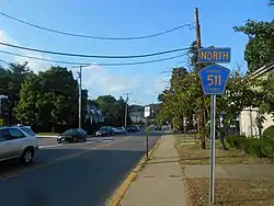
Interstate 287 is the most significant highway passing through Bloomingdale. However, there is no direct access to it within Bloomingdale, with the nearest interchanges being in adjacent towns. County Route 511 is the most significant road serving Bloomingdale directly.
Public transportation
Bloomingdale was served by the New York, Susquehanna and Western Railway commuter passenger service until 1966. NJ Transit provides bus transportation on the 194 route to the Port Authority Bus Terminal in Midtown Manhattan.[100][101] In September 2012, as part of budget cuts, NJ Transit suspended service to Newark on the 75 line.[102]
Notable people
People who were born in, residents of, or otherwise closely associated with Bloomingdale include:
- Michael DuHaime (born 1974), campaign manager of Rudolph Giuliani's campaign for the 2008 Republican presidential nomination.[103]
- Wendy Larry, former head coach of the Old Dominion Lady Monarchs women's basketball team.[104]
- Tim O'Connor (1927-2018), character actor known for his prolific work in television, including Peyton Place.[105]
- Scott A. Spellmon, 55th Chief of Engineers of the United States Army and the commanding general of the U.S. Army Corps of Engineers.[106]
References
- 2019 Census Gazetteer Files: New Jersey Places, United States Census Bureau. Accessed July 1, 2020.
- US Gazetteer files: 2010, 2000, and 1990, United States Census Bureau. Accessed September 4, 2014.
- 2012 New Jersey Legislative District Data Book, Rutgers University Edward J. Bloustein School of Planning and Public Policy, March 2013, p. 121.
- Borough Council, Borough of Bloomingdale. Accessed March 19, 2020.
- 2020 New Jersey Mayors Directory, New Jersey Department of Community Affairs. Accessed February 1, 2020.
- Wildstein, David. "Bloomingdale mayor dies at 56; Jonathan Dunleavy has been mayor since 2011", New Jersey Globe, November 7, 2020. Accessed November 8, 2020. "Bloomingdale Mayor Jonathan Dunleavy passed away suddenly on Friday night. He was 56."
- Business Administrator Leaving Bloomingdale, Tri-Boro Patch. Accessed January 15, 2013.
- Administration, Borough of Bloomingdale. Accessed March 19, 2020.
- Municipal Clerk, Borough of Bloomingdale. Accessed March 19, 2020.
- U.S. Geological Survey Geographic Names Information System: Borough of Bloomingdale, Geographic Names Information System. Accessed March 4, 2013.
- DP-1 - Profile of General Population and Housing Characteristics: 2010 for Bloomingdale borough, Passaic County, New Jersey, United States Census Bureau. Accessed July 10, 2012.
- Municipalities Sorted by 2011-2020 Legislative District, New Jersey Department of State. Accessed February 1, 2020.
- Profile of General Demographic Characteristics: 2010 for Bloomingdale borough Archived 2014-04-24 at the Wayback Machine, New Jersey Department of Labor and Workforce Development. Accessed July 10, 2012.
- QuickFacts for Bloomingdale borough, New Jersey; Passaic County, New Jersey; New Jersey from Population estimates, July 1, 2019, (V2019), United States Census Bureau. Accessed May 21, 2020.
- GCT-PH1 Population, Housing Units, Area, and Density: 2010 - State -- County Subdivision from the 2010 Census Summary File 1 for New Jersey , United States Census Bureau. Accessed December 11, 2012.
- Look Up a ZIP Code for Bloomingdale, NJ, United States Postal Service. Accessed July 10, 2012.
- ZIP Codes, State of New Jersey. Accessed August 27, 2013.
- Area Code Lookup - NPA NXX for Bloomingdale, NJ, Area-Codes.com. Accessed January 26, 2015.
- U.S. Census website , United States Census Bureau. Accessed September 4, 2014.
- Geographic Codes Lookup for New Jersey, Missouri Census Data Center. Accessed July 10, 2012.
- US Board on Geographic Names, United States Geological Survey. Accessed September 4, 2014.
- Table 7. Population for the Counties and Municipalities in New Jersey: 1990, 2000 and 2010, New Jersey Department of Labor and Workforce Development, February 2011. Accessed July 10, 2012.
- LaPlaca, Bryan. "Back in the Day - June 2, 1976: Washington put down Bloomingdale mutiny", The Record, June 13, 2011. Accessed July 10, 2012. "A mutiny that could have changed the course of the American Revolution occurred at the Pompton Encampment during the winter of 1780-1781 near Federal Hill in present-day Bloomingdale."
- Snyder, John P. The Story of New Jersey's Civil Boundaries: 1606-1968, Bureau of Geology and Topography; Trenton, New Jersey; 1969. p. 209. Accessed July 10, 2012.
- Bloomingdale, New Jersey Minor League City Encyclopedia, Baseball-Reference.com. Accessed January 26, 2015.
- Butler Museum
- Morristown Library
- "Paterson Library". Archived from the original on May 29, 2005. Retrieved June 28, 2005.
- New Jersey State Archives
- Kirby, David. "Havens; Weekender | Bloomingdale, N.J.", The New York Times, March 28, 2003. Accessed March 16, 2018.
- Locality Search, State of New Jersey. Accessed May 22, 2015.
- Areas touching Bloomingdale, MapIt. Accessed March 19, 2020.
- Passaic County Map, Coalition for a Healthy NJ. Accessed March 19, 2020.
- New Jersey Municipal Boundaries, New Jersey Department of Transportation. Accessed November 15, 2019.
- Annual Estimates of the Resident Population for Minor Civil Divisions in New Jersey: April 1, 2010 to July 1, 2019, United States Census Bureau. Accessed May 21, 2020.
- Census Estimates for New Jersey April 1, 2010 to July 1, 2019, United States Census Bureau. Accessed May 21, 2020.
- Compendium of censuses 1726-1905: together with the tabulated returns of 1905, New Jersey Department of State, 1906. Accessed August 27, 2013.
- Fifteenth Census of the United States : 1930 - Population Volume I, United States Census Bureau, p. 718. Accessed July 10, 2012.
- New Jersey Resident Population by Municipality: 1930 - 1990, Workforce New Jersey Public Information Network. Accessed June 28, 2015.
- Census 2000 Profiles of Demographic / Social / Economic / Housing Characteristics for Bloomingdale borough Archived 2008-10-12 at the Wayback Machine, United States Census Bureau. Accessed July 10, 2012.
- DP-1: Profile of General Demographic Characteristics: 2000 - Census 2000 Summary File 1 (SF 1) 100-Percent Data for Bloomingdale borough, New Jersey, United States Census Bureau. Accessed July 10, 2012.
- DP03: Selected Economic Characteristics from the 2006-2010 American Community Survey 5-Year Estimates for Bloomingdale borough, Passaic County, New Jersey, United States Census Bureau. Accessed July 10, 2012.
- Lipman, Harvy; and Sheingold, Dave. "North Jersey sees 30% growth in same-sex couples", The Record, August 14, 2011, backed up by the Internet Archive as of February 3, 2013. Accessed December 1, 2014.
- Inventory of Municipal Forms of Government in New Jersey, Rutgers University Center for Government Studies, July 1, 2011. Accessed November 18, 2019.
- Cerra, Michael F. "Forms of Government: Everything You've Always Wanted to Know, But Were Afraid to Ask" Archived 2014-09-24 at the Wayback Machine, New Jersey State League of Municipalities. Accessed November 30, 2014.
- "Forms of Municipal Government in New Jersey", p. 6. Rutgers University Center for Government Studies. Accessed June 3, 2015.
- 2019 Municipal Data Sheet, Borough of Bloomingdale. Accessed March 19, 2020.
- Passaic County 2019 Directory Archived April 18, 2020, at the Wayback Machine, Passaic County, New Jersey, November 2019. Accessed March 19, 2020.
- 2019 General Election November 5, 2019 Summary Report Passaic County Official Results, Passaic County, New Jersey, updated November 18, 2019. Accessed January 1, 2020.
- 2018 General Election November 6, 2018 Summary Report Passaic County Official Results, Passaic County, New Jersey, updated November 30, 2018. Accessed January 1, 2019.
- 2017 General Election November 7, 2017 Summary Report Passaic County Official Results, Passaic County, New Jersey, updated November 20, 2017. Accessed January 1, 2018.
- Plan Components Report, New Jersey Redistricting Commission, December 23, 2011. Accessed February 1, 2020.
- 2019 New Jersey Citizen's Guide to Government, New Jersey League of Women Voters. Accessed October 30, 2019.
- Districts by Number for 2011-2020, New Jersey Legislature. Accessed January 6, 2013.
- 2011 New Jersey Citizen's Guide to Government Archived 2013-06-04 at the Wayback Machine, p. 55, New Jersey League of Women Voters. Accessed May 22, 2015.
- Directory of Representatives: New Jersey, United States House of Representatives. Accessed January 3, 2019.
- About Cory Booker, United States Senate. Accessed January 26, 2015. "He now owns a home and lives in Newark's Central Ward community."
- Biography of Bob Menendez, United States Senate, January 26, 2015. "He currently lives in Paramus and has two children, Alicia and Robert."
- Senators of the 116th Congress from New Jersey. United States Senate. Accessed April 17, 2019. "Booker, Cory A. - (D - NJ) Class II; Menendez, Robert - (D - NJ) Class I"
- Legislative Roster 2020-2021 Session, New Jersey Legislature. Accessed December 15, 2020.
- District 39 Legislators, New Jersey Legislature. Accessed December 15, 2020.
- Clerk-Freeholders, Passaic County, New Jersey. Accessed August 1, 2017.
- Cassandra Lazzara, Passaic County, New Jersey. Accessed August 1, 2017.
- Bruce James, Passaic County, New Jersey. Accessed August 1, 2017.
- Assad Akhter, Passaic County, New Jersey. Accessed August 1, 2017.
- John W. Bartlett, Passaic County, New Jersey. Accessed August 1, 2017.
- Theodore O. Best Jr., Passaic County, New Jersey. Accessed August 1, 2017.
- Terry Duffy, Passaic County, New Jersey. Accessed August 1, 2017.
- Pat Lepore, Passaic County, New Jersey. Accessed August 1, 2017.
- Freeholders, Passaic County, New Jersey. Accessed August 1, 2017.
- Passaic County 2017 Directory, Passaic County, New Jersey. Accessed August 1, 2017.
- 2017 County Data Sheet, Passaic County, New Jersey. Accessed August 1, 2017.
- County Clerk, Passaic County, New Jersey. Accessed August 1, 2017.
- Sheriff Richard H. Berdnik, Passaic County Sheriff's Office. Accessed August 1, 2017.
- County Surrogate, Passaic County, New Jersey. Accessed August 1, 2017.
- Assembly Committee Substitute for Assembly, No. 2635, New Jersey Legislature, June 7, 2004. Accessed October 31, 2014.
- DEP Guidance for the Highlands Water Protection and Planning Act-Highlands Region Counties and Municipalities; Highlands Municipalities, New Jersey Department of Environmental Protection, updated July 8, 2014. Accessed October 31, 2014.
- Voter Registration Summary - Passaic, New Jersey Department of State Division of Elections, March 23, 2011. Accessed January 16, 2013.
- GCT-P7: Selected Age Groups: 2010 - State -- County Subdivision; 2010 Census Summary File 1 for New Jersey , United States Census Bureau. Accessed January 16, 2013.
- "Presidential General Election Results - November 6, 2012 - Passaic County" (PDF). New Jersey Department of Elections. March 15, 2013. Retrieved December 24, 2014.
- "Number of Registered Voters and Ballots Cast - November 6, 2012 - General Election Results - Passaic County" (PDF). New Jersey Department of Elections. March 15, 2013. Retrieved December 24, 2014.
- 2008 Presidential General Election Results: Passaic County, New Jersey Department of State Division of Elections, December 23, 2008. Accessed January 16, 2013.
- 2004 Presidential Election: Passaic County, New Jersey Department of State Division of Elections, December 13, 2004. Accessed January 16, 2013.
- "Governor - Passaic County" (PDF). New Jersey Department of Elections. January 29, 2014. Retrieved December 24, 2014.
- "Number of Registered Voters and Ballots Cast - November 5, 2013 - General Election Results - Passaic County" (PDF). New Jersey Department of Elections. January 29, 2014. Retrieved December 24, 2014.
- 2009 Governor: Passaic County Archived 2012-08-22 at the Wayback Machine, New Jersey Department of State Division of Elections, December 31, 2009. Accessed January 16, 2013.
- Bloomingdale Board of Education District Polict 0110 - Identification, Bloomingdale School District. Accessed February 7, 2020. "Purpose: The Board of Education exists for the purpose of providing a thorough and efficient system of free public education in grades Pre-Kindergarten through eight in the Bloomingdale School District. Composition: The Bloomingdale School District is comprised of all the area within the municipal boundaries of Bloomingdale Borough."
- District information for Bloomingdale School District, National Center for Education Statistics. Accessed November 1, 2019.
- School Data for the Bloomingdale School District, National Center for Education Statistics. Accessed November 1, 2019.
- Martha B. Day Elementary School, Bloomingdale School District. Accessed February 7, 2020.
- Samuel R. Donald Elementary School, Bloomingdale School District. Accessed February 7, 2020.
- Walter T. Bergen Middle School, Bloomingdale School District. Accessed February 7, 2020.
- Schools, Bloomingdale School District. Accessed February 7, 2020.
- New Jersey School Directory for the Bloomingdale School District, New Jersey Department of Education. Accessed December 29, 2016.
- Passaic County 2018-19 Public School Directory, Passaic County, New Jersey. Accessed February 7, 2020.
- Butler Public Schools 2016 Report Card Narrative, New Jersey Department of Education. Accessed December 14, 2017. "The district also engages in several Shared Service agreements with the Bloomingdale school district, beyond the send-receive high school experience, including sharing of school Library oversight, Special Education and sharing the services of the Student Assistance Counselor."
- Profile 2012-2013, Butler High School. Accessed January 26, 2015. "Butler High School is a public high school servicing the students of the Borough of Butler and the Borough of Bloomingdale."
- School data for Butler High School, National Center for Education Statistics. Accessed November 1, 2019.
- Passaic County Mileage by Municipality and Jurisdiction, New Jersey Department of Transportation, May 2010. Accessed July 18, 2014.
- Passaic County Bus / Rail Connections, NJ Transit backed up by the Internet Archive as of July 26, 2010. Accessed December 1, 2014.
- Passaic County System Map, NJ Transit. Accessed August 12, 2015.
- Rouse, Karen. "N.J. Transit bus No. 75, running from Passaic County to Newark, will no longer operate", The Record, August 29, 2012. Accessed August 5, 2015. "Starting Saturday, the NJ Transit No. 75 bus — which runs from Butler through Pompton Lakes, Pequannock, Wayne and Little Falls on its way to Newark — will no longer operate as NJ Transit's plan to save $2.5 million in operating costs takes effect."
- Rispoli, Michael. "McCain's Team Has Many Roots In Jersey", Asbury Park Press, September 4, 2008. Accessed July 10, 2012. "That reputation for being a gimmee for Democrats also churns out Republican operatives who have to deal with tough losses and think innovatively to win votes, said Bloomingdale native Michael DuHaime, political director for McCain's campaign."
- Staff. "Wendy Larry resigns as head coach" Archived 2011-05-29 at the Wayback Machine, WVBT, May 17, 2011. Accessed June 6, 2011. "Larry is a native of Bloomingdale, N.J., and was recently inducted into the Butler High School Hall of Fame in April."
- Feldman, Kate. "Tim O’Connor, Peyton Place star, dead at 90", New York Daily News, April 12, 2018. Accessed August 7, 2019. "Before launching his TV career, O'Connor worked on stage in New York with legends including Sir Laurence Olivier and Maureen O'Hara, commuting from a house on an island in Glen Wild Lake, near Bloomingdale, N.J., where he lived with first wife Mary." Note that Glen Wild Lake is in Bloomingdale (not merely "near" it)."
- "Bloomingdale native promoted to brigadier general", United States Army Test and Evaluation Command via The Record, October 8, 2013. Accessed January24, 2021. "Bloomingdale native Scott A. Spellmon was promoted to brigadier general in a ceremony at Fort Hood, Texas, last week.... A 1982 graduate of Butler High School, Spellmon was commissioned a second lieutenant from the United States Military Academy at West Point in 1986."
External links
| Wikimedia Commons has media related to Bloomingdale, New Jersey. |
Municipalities and communities of Passaic County, New Jersey, United States | ||
|---|---|---|
| Cities | 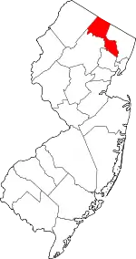 Map of New Jersey highlighting Passaic County | |
| Boroughs | ||
| Townships | ||
| CDPs | ||
| Other unincorporated communities | ||
| ||
Places adjacent to Bloomingdale, New Jersey | ||||||||||
|---|---|---|---|---|---|---|---|---|---|---|
| ||||||||||
| Authority control |
|---|