Blue Mountain (Pennsylvania)
Blue Mountain, Blue Mountain Ridge, or the Blue Mountains of Pennsylvania is a ridge of the Appalachian Mountains in the U.S. state of Pennsylvania. Forming the southern and eastern edge of the Ridge-and-Valley Appalachians physiographic province in Pennsylvania, Blue Mountain extends 150 miles (240 km) from the Delaware Water Gap on the New Jersey border in the east to Big Gap in Franklin County, south-central Pennsylvania, at its southwestern end.
| Blue Mountain[2] | |
|---|---|
Kittatinny Mountain (and nine others:
| |
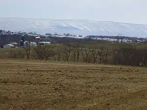 The "Great Wall" of Blue Mountain | |
| Highest point | |
| Peak | Clarks Knob 2,320 feet (710 m)[4] |
| Elevation | 1,129 ft (344 m) [2] |
| Coordinates | 40°07′28″N 77°39′59″W |
| Dimensions | |
| Length | 150 mi (240 km) northeast-southwest to SSW 150 miles (240 km) (direct aerial) 255 miles (410 km) trace of ridgeline, including loops back[5] width = varies along chain's length |
| Geography | |
| Country | United States |
| State | Pennsylvania |
| Borders on | Ridge-and-Valley Appalachians and Great Appalachian Valley |
| Geology | |
| Orogeny | Appalachian Mountains |
| Age of rock | Silurian |
| Type of rock | Tuscarora Formation and Shawangunk Formation; sedimentary |
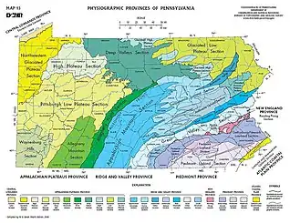
Some distant view of "the Blue Mountain" dominates the southern tier of most eastern and central Pennsylvanian counties, providing an ever-visible backdrop cutting across the northern or western horizon. Most transport corridors and road beds piercing the barrier necessarily pass through either large water gaps (west to east: the Susquehanna, Schuylkill, Lehigh and Delaware River valleys) or wind gaps, low gaps in the ridge caused by ancient watercourses. The barrier ridge forms a distinct boundary between a number of Pennsylvania's geographical and cultural regions.
To the south of the Susquehanna River gap in the south-central part of the state is the Cumberland Valley, part of the Great Appalachian Valley; to its northwest side are the southern reaches of the Susquehanna Valley with picturesque streams channeling travel corridors deep into and over the central and western mountains and valleys—the heartland interior counties of Pennsylvania; along the Main Branch Susquehanna, the valleys also lead into northeast Pennsylvania, into the "Northern Coal Region" of the Wyoming Valley and the distant Poconos. To the south of Blue Mountain lies the "Capital Region" about Harrisburg and nearby communities, the rich farming country of the Lebanon Valley and the Pennsylvania Dutch Country of York and Lancaster counties, the lower half of the Lehigh Valley, and the lower Delaware Valley; the latter two extend north through water gaps beyond the ridgeline.
Geography
The ridge of Blue Mountain runs for 150 miles (240 km) through Pennsylvania, reaching an elevation of 2,270 feet (690 m) above sea level just north of the Pennsylvania Turnpike, near the borough of Newburg. Most of the ridgecrest, however, only reaches between 1,400 and 1,700 feet (430 and 520 m) in elevation. The mountain's width varies from 1 to 3 miles (1.6 to 4.8 km).
The southwestern end of the mountain is at Big Gap, west of Shippensburg. (The mountain ridge continues to the southwest toward Maryland under the name of "Broad Mountain".) The northeastern end of the mountain is at the Delaware Water Gap on the New Jersey border. Mount Minsi, elevation 1,461 feet (445 m), forms the promontory overlooking the Delaware River. The ridge of Blue Mountain continues northeast into New Jersey as Kittatinny Mountain.[6]
Blue Mountain marks the boundary between the Great Appalachian Valley and the main Ridge-and-Valley Appalachians.
Water gaps
Four of Pennsylvania's major rivers cut through Blue Mountain in water gaps.
- The Delaware River, which forms Pennsylvania's eastern border with New Jersey, passes through the ridge just southeast of Stroudsburg.
- The Lehigh River, which feeds the Delaware at Easton, passes through the ridge near Palmerton.
- The Schuylkill River, which feeds the Delaware at Philadelphia, passes through the ridge just north of Hamburg.
- The Susquehanna River, which feeds the Chesapeake Bay, passes through the ridge just north of Harrisburg, Pennsylvania's capital.
The Pennsylvania Turnpike

The Pennsylvania Turnpike system passes through Blue Mountain at two points.
- The Blue Mountain Tunnel carries the turnpike's east–west mainline (Interstate 76) through the ridge in northern Franklin County. The Kittatinny Mountain Tunnel bores through a parallel ridge of the same mountain just to the west, with the two tunnel portals only 0.2 miles (0.32 km) apart.
- The Lehigh Tunnel, so named to avoid confusion with the former, carries the turnpike's north–south Northeast Extension (Interstate 476) through the ridge between Lehigh and Carbon counties. Both tunnels (each consisting of two tubes) carry two lanes in each direction of travel.
Blue Mountain attractions in Pennsylvania
- The Appalachian Trail is concurrent with the top of the ridge from New Jersey to northern Lebanon County.
- Hawk Mountain Sanctuary is located at the very northern edge of Berks County.
- Hawk Mountain Ranger School, located just south of the Sanctuary, trains Civil Air Patrol members for their ground search and rescue Ranger Teams.
- Blue Mountain Ski Area is found on the north face of the ridge in the southeastern corner of Carbon County.
- Delaware Water Gap National Recreation Area reaches across Northampton, Monroe, and Pike counties and into New Jersey, mostly to the northwest of the ridge.
- Boyd Big Tree Preserve Conservation Area in Dauphin County
Blue Mountain School District is named after the mountain range. It is located just off Route 61 in Schuylkill Haven, Pennsylvania.
See also
References
- "Blue Ridge Mountain". Geographic Names Information System. United States Geological Survey. Retrieved 2017-03-29.
- "Blue Mountain". Geographic Names Information System. United States Geological Survey. Retrieved 2009-02-07.
- What's in a name, Spanning the Gap newsletter of the Delaware Water Gap National Recreation Area, Summer 1984
- "Clarks Knob". Geographic Names Information System. United States Geological Survey. Retrieved 2009-02-08.
- Measured along ridge point by point using maps.google.com ruler tool, anchored on New Jersey border, to Maryland border., 29 March 2017.
- U.S. Geological Survey 1:24,000-scale and 1:250,000-scale topographic map series