Northampton County, Pennsylvania
Northampton County is a county in the northeastern section of the U.S. state of Pennsylvania. As of the 2010 census, the population was 297,735.[1] Its county seat is Easton.[2] The county was formed in 1752 from parts of Bucks County. Its namesake was Northamptonshire, England. The county seat of Easton was named for the country house Easton Neston in that shire.
Northampton County | |
|---|---|
 Seal | |
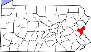 Location within the U.S. state of Pennsylvania | |
 Pennsylvania's location within the U.S. | |
| Coordinates: 40°45′N 75°19′W | |
| Country | |
| State | |
| Founded | March 11, 1752 |
| Named for | Northamptonshire |
| Seat | Easton |
| Largest city | Bethlehem |
| Area | |
| • Total | 377 sq mi (980 km2) |
| • Land | 370 sq mi (1,000 km2) |
| • Water | 7.7 sq mi (20 km2) 2.0%% |
| Population | |
| • Estimate (2019) | 305,285 |
| • Density | 813/sq mi (314/km2) |
| Time zone | UTC−5 (Eastern) |
| • Summer (DST) | UTC−4 (EDT) |
| Congressional district | 7th |
| Website | www |
Northampton County is included in the Allentown-Bethlehem-Easton, PA-NJ Metropolitan Statistical Area. Its northern edge borders The Poconos, and its eastern section borders the Delaware River, which divides Pennsylvania and New Jersey.
Northampton County also borders the Delaware Valley and is included in Philadelphia's Media Market.
The county is industrially oriented, producing cement, and other industrial products. It was a center of cement production, with the world's then-largest cement producer, Atlas Portland Cement Company, operating here for nearly 100 years, from 1895 until 1982.[3] Bethlehem Steel, once one of the world's largest manufacturers of steel, was located in this county prior to its closing in 2003.
Geography
According to the U.S. Census Bureau, the county has a total area of 377 square miles (980 km2), of which 370 square miles (960 km2) is land and 7.7 square miles (20 km2) (2.0%) is water.[4] The climate is humid continental (mostly Dfa with a little Dfb in higher northern areas) and the hardiness zones are 6b and 6a. Average monthly temperatures in downtown Bethlehem average from 29.1 °F in January to 74.1 °F in July, while in Wind Gap they average from 27.0 °F in January to 71.7 °F in July.
Adjacent counties
- Monroe County (north)
- Warren County, New Jersey (east)
- Bucks County (south)
- Lehigh County (west)
- Carbon County (northwest)
National protected areas
Demographics
| Historical population | |||
|---|---|---|---|
| Census | Pop. | %± | |
| 1790 | 24,220 | — | |
| 1800 | 30,062 | 24.1% | |
| 1810 | 38,145 | 26.9% | |
| 1820 | 31,765 | −16.7% | |
| 1830 | 39,482 | 24.3% | |
| 1840 | 40,996 | 3.8% | |
| 1850 | 40,235 | −1.9% | |
| 1860 | 47,904 | 19.1% | |
| 1870 | 61,432 | 28.2% | |
| 1880 | 70,312 | 14.5% | |
| 1890 | 84,220 | 19.8% | |
| 1900 | 99,687 | 18.4% | |
| 1910 | 127,667 | 28.1% | |
| 1920 | 153,506 | 20.2% | |
| 1930 | 169,304 | 10.3% | |
| 1940 | 168,959 | −0.2% | |
| 1950 | 185,243 | 9.6% | |
| 1960 | 201,412 | 8.7% | |
| 1970 | 214,368 | 6.4% | |
| 1980 | 225,418 | 5.2% | |
| 1990 | 247,105 | 9.6% | |
| 2000 | 267,066 | 8.1% | |
| 2010 | 297,735 | 11.5% | |
| 2019 (est.) | 305,285 | [5][6][7] | 2.5% |
| U.S. Decennial Census[8] 1790-1960[9] 1900-1990[10] 1990-2000[11] 2010-2019[1] | |||
As of the 2010 census, the county was 81.0% White Non-Hispanic, 5.0% Black or African American, 0.2% Native American or Alaskan Native, 2.4% Asian, 0.0% Native Hawaiian, 2.2% were two or more races, and 3.8% were some other race. 10.5% of the population were of Hispanic or Latino ancestry.
As of the census[12] of 2000, there were 267,066 people, 101,541 households, and 71,078 families residing in the county. The population density was 714 people per square mile (276/km2). There were 106,710 housing units at an average density of 286 per square mile (110/km2). The racial makeup of the county was 91.23% White, 2.77% Black or African American, 0.15% Native American, 1.37% Asian, 0.03% Pacific Islander, 3.06% from other races, and 1.39% from two or more races. 6.69% of the population were Hispanic or Latino of any race. 24.0% were of German, 14.0% Italian, 8.8% Irish, 5.1% English and 5.1% American ancestry. 89.3% spoke English and 5.5% Spanish as their first language.
There were 101,541 households, out of which 31.20% had children under the age of 18 living with them, 56.40% were married couples living together, 9.80% had a female householder with no husband present, and 30.00% were non-families. 24.70% of all households were made up of individuals, and 11.20% had someone living alone who was 65 years of age or older. The average household size was 2.53 and the average family size was 3.02.
In the county, the population was spread out, with 23.30% under the age of 18, 9.20% from 18 to 24, 28.30% from 25 to 44, 23.40% from 45 to 64, and 15.70% who were 65 years of age or older. The median age was 38 years. For every 100 females there were 94.80 males. For every 100 females age 18 and over, there were 91.70 males.
Government
Northampton is one of the seven counties in Pennsylvania which has adopted a home rule charter. Voters elect an Executive, a nine-person Council, a Controller, and a District Attorney. The Executive, Controller and District Attorney are elected at-large by all voters in the County
Five members of the council are also elected at-large. The other four members of the council are elected from single-member districts. This weighted structure of government favors the majority of voters, but it does allow for representation of minority groups, if they live within a compact voting district. The Row Officers are nominated by the county executive and approved by county council.
- County Executive:
- Lamont McClure, Democrat
- County Council:
- Ronald R. Heckman - President, Democrat
- Lori Vargo Heffner - Vice President, Democrat
- Margaret (Peg) Ferraro, Republican
- William B. McGee, Democrat
- Kevin Lott - Democrat
- Tom Giovanni - Republican
- Tara Zrinski, Democrat
- John Cusick, Republican
- Kerry Myers, Democrat
- Clerk of Courts:
- Leigh Ann Fisher, Democrat
- County Controller:
- Tony Bassil, Democrat
- District Attorney:
- Terry Houck, Democrat
- Prothonotary:
- Holly Ruggiero, Democrat
- Register of Wills:
- Gina Gibbs, Democrat
- Sheriff:
- Richard Johnston
Politics
| Year | Republican | Democratic | Third parties |
|---|---|---|---|
| 2020 | 48.9% 83,854 | 49.6% 85,087 | 1.4% 2,458 |
| 2016 | 49.6% 71,736 | 45.8% 66,272 | 4.5% 6,558 |
| 2012 | 46.9% 61,446 | 51.6% 67,606 | 1.5% 1,992 |
| 2008 | 43.1% 58,551 | 55.4% 75,255 | 1.6% 2,148 |
| 2004 | 49.0% 62,102 | 50.0% 63,446 | 1.0% 1,301 |
| 2000 | 45.3% 47,396 | 50.7% 53,097 | 4.0% 4,197 |
| 1996 | 39.3% 35,726 | 48.3% 43,959 | 12.4% 11,317 |
| 1992 | 35.3% 34,429 | 43.3% 42,203 | 21.4% 20,893 |
| 1988 | 51.5% 42,748 | 47.3% 39,264 | 1.2% 966 |
| 1984 | 53.5% 44,648 | 45.5% 37,979 | 1.0% 840 |
| 1980 | 47.1% 35,787 | 42.0% 31,920 | 11.0% 8,330 |
| 1976 | 42.8% 32,926 | 55.2% 42,514 | 2.0% 1,521 |
| 1972 | 56.3% 41,822 | 43.5% 32,335 | 0.2% 124 |
| 1968 | 41.0% 32,033 | 54.5% 42,554 | 4.5% 3,543 |
| 1964 | 26.2% 21,048 | 73.1% 58,818 | 0.8% 619 |
| 1960 | 49.4% 40,683 | 50.5% 41,552 | 0.1% 71 |
| 1956 | 55.8% 43,375 | 43.4% 33,749 | 0.7% 573 |
| 1952 | 51.0% 39,131 | 48.2% 36,993 | 0.8% 614 |
| 1948 | 44.0% 27,030 | 54.0% 33,209 | 2.1% 1,265 |
| 1944 | 44.8% 26,643 | 54.8% 32,584 | 0.5% 292 |
| 1940 | 43.1% 25,385 | 56.5% 33,304 | 0.5% 269 |
| 1936 | 37.3% 22,827 | 60.3% 36,871 | 2.4% 1,438 |
| 1932 | 45.0% 20,779 | 52.0% 24,009 | 2.9% 1,345 |
| 1928 | 71.1% 37,403 | 28.1% 14,768 | 0.8% 404 |
| 1924 | 58.4% 20,459 | 32.7% 11,459 | 8.9% 3,104 |
| 1920 | 58.8% 14,227 | 37.5% 9,086 | 3.7% 891 |
| 1916 | 44.4% 9,610 | 50.8% 11,000 | 4.9% 1,050 |
| 1912 | 17.9% 3,893 | 47.5% 10,325 | 34.6% 7,518 |
| 1908 | 46.9% 10,857 | 49.1% 11,365 | 4.0% 923 |
| 1904 | 51.2% 11,039 | 46.0% 9,914 | 2.8% 604 |
| 1900 | 45.1% 9,849 | 52.3% 11,412 | 2.6% 556 |
| 1896 | 47.6% 9,762 | 48.9% 10,032 | 3.5% 717 |
| 1892 | 39.2% 6,892 | 58.7% 10,320 | 2.1% 367 |
| 1888 | 39.7% 6,785 | 58.6% 10,027 | 1.7% 291 |
| 1884 | 39.4% 6,327 | 59.1% 9,491 | 1.4% 224 |
| 1880 | 37.9% 5,961 | 61.3% 9,653 | 0.7% 114 |
As of December 2020 there were 227,400 registered voters in Northampton County
- Democratic: 102,247 (44.96%)
- Republican: 81,446 (35.84%)
- Other parties: 43,707 (19.22%)
In recent decades, Northampton has been identified as one of Pennsylvania's "swing counties," with statewide winners carrying it in most cases; since 1952, it has gone to the statewide winner in the presidential election.[14] All five statewide winners carried it in November 2004 and all four statewide Democratic candidates carried it in November 2008, with District Attorney John Morganelli doing well there despite losing statewide to incumbent Attorney General Tom Corbett. The Democratic Party has been dominant most of the time in county-level politics in recent decades. In 2014, John Brown bucked that trend when he became the only Republican in the 21st Century to be elected Northampton County executive, a harbinger of Donald Trump winning the county and the state at the presidential level in 2016. Lamont McClure retook the county executive position for the Democrats in 2018; Joe Biden won Northampton County and Pennsylvania in 2020.
Voting Machine Problems
Municipal elections were held across Pennsylvania in November, 2019, and results in Northampton County were plagued with problems caused by newly purchased machines, The ExpressVoteXL, sold by the manufacturer Election Systems & Software (ES&S) as "a luxury “one-stop” voting system." According to the New York Times and other publications, it was a few minutes after the polls closed on Election Day when panic began to spread through the Northampton county election offices. Vote totals in one judge’s race showed one candidate, Abe Kassis, a Democrat, had just 164 votes out of 55,000 ballots across more than 100 precincts. Some machines reported zero votes for him.
The voting system, used in numerous Pennsylvania jurisdictions, combines a touch screen with a paper ballot backup. County officials determined the results by counting the paper ballots, which showed Mr. Kassis had won by 1,054 votes. Unofficial results were announced at 6AM on November 6th. The election results were certified following a canvass and audit. No challenges to the election results were filed.
County executives
| Name | Party | Term start | Term end |
|---|---|---|---|
| Glenn F. Reibman | Democratic | 1998 | 2006 |
| John Stoffa | Democratic | 2006 | 2014 |
| John Brown | Republican | 2014 | 2018 |
| Lamont McClure | Democratic | 2018 | Incumbent |
County Council members
- Ronald R. Heckman, President, Democrat, at large
- Lori Vargo Heffner, Vice President, Democrat, at large
- Margaret (Peg) Ferraro, Republican, at large
- Tara Zrinski, Democrat, at large
- William B. McGee, Democrat, at large
- Kevin Lott, Democrat, district 1
- Kerry Meyers, Democrat, district 2
- John Cusick, Republican, district 3
- Tom Giovanni, Republican, district 4
State representatives[15]
- Justin Simmons, Republican, 131st district
- Steve Samuelson, Democrat, 135th district
- Robert L. Freeman, Democrat, 136th district
- Joe Emrick, Republican, 137th district
- Marcia Hahn, Republican, 138th district
- Zach Mako, Republican, 183rd district
State senators[15]
- Lisa Boscola, Democrat, 18th district
- Mario M. Scavello, Republican, 40th district
United States House of Representatives
- Susan Wild, Democrat, 7th district
United States Senate
Education
Colleges and universities
- Lafayette College, Easton
- Lehigh University, Bethlehem
- Moravian College, Bethlehem
- Northampton County Area Community College, Bethlehem Township
- Respect Graduate School, Bethlehem
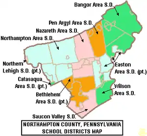
Public school districts
Public charter schools
The Lehigh Valley Charter High School for the Performing Arts, Bethlehem
Private high schools
- Bethlehem Catholic High School, Bethlehem
- Moravian Academy, Bethlehem
- Notre Dame High School, Bethlehem Township
Transportation
Air transportation
Air transport to and from Northampton County is available through Lehigh Valley International Airport (IATA: ABE, ICAO: KABE).
Bus transportation
Public bus service in Northampton County is available through the Lehigh and Northampton Transportation Authority, known as LANTA. A shuttle bus service, The Bethlehem Loop, also operates in Bethlehem. NJ Transit provides service from Easton's Centre Square to the Phillipsburg area.
Telecommunications
Northampton County was once served only by the 215 area code from 1947 (when the North American Numbering Plan of the Bell System went into effect) until 1994. With the county's growing population, however, Northampton County was afforded area code 610 in 1994. Today, Northampton County is covered by 610 except for the Portland exchange which uses 570. An overlay area code, 484, was added to the 610 service area in 1999.[16] A plan to introduce area code 835 as an additional overlay was rescinded in 2001.[17]
Recreation
There are 2 Pennsylvania state parks in Northampton County.
- Delaware Canal State Park follows the course of the old Delaware Canal along the Delaware River from Easton in Northampton County to Bristol in Bucks County.
- Jacobsburg Environmental Education Center
Communities
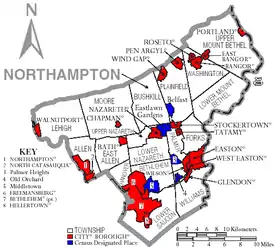
Under Pennsylvania law, there are four types of incorporated municipalities: cities, boroughs, townships, and two towns. The following cities, boroughs and townships are located in Northampton County:
Cities
- Bethlehem (partly in Lehigh County)
- Easton (county seat)
Boroughs
Townships
Census-designated places
Census-designated places are geographical areas designated by the U.S. Census Bureau for the purposes of compiling demographic data. They are not actual jurisdictions under Pennsylvania law. Other unincorporated communities, such as villages, may be listed here as well.
Population ranking
The population ranking of the following table is based on the 2010 census of Northampton County.[18]
† county seat
| Rank | City/borough/township/etc. | Municipal type | Population (2010 Census) |
|---|---|---|---|
| 1 | Bethlehem (partially in Lehigh County) | City | 74,982 |
| 2 | † Easton | City | 26,800 |
| 3 | Bethlehem Township | Township | 23,730 |
| 4 | Palmer Township | Township | 20,691 |
| 5 | Forks Township | Township | 14,721 |
| 6 | Hanover Township | Township | 10,866 |
| 7 | Lower Saucon Township | Township | 10,772 |
| 8 | Lehigh Township | Township | 10,527 |
| 9 | Northampton | Borough | 9,926 |
| 10 | Moore Township | Township | 9,198 |
| 11 | Bushkill Township | Township | 8,178 |
| 12 | Wilson | Borough | 7,896 |
| 13 | Middletown | CDP | 7,441 |
| 14 | Upper Mount Bethel Township | Township | 6,706 |
| 15 | Upper Nazareth Township | Township | 6,231 |
| 16 | Plainfield Township | Township | 6,138 |
| 17 | Hellertown | Borough | 5,898 |
| 18 | Williams Township | Township | 5,884 |
| 19 | Nazareth | Borough | 5,746 |
| 20 | Lower Nazareth Township | Township | 5,674 |
| 21 | Bangor | Borough | 5,273 |
| 22 | Washington Township | Township | 5,122 |
| 23 | East Allen Township | Township | 4,930 |
| 24 | Allen Township | Township | 4,269 |
| 25 | Palmer Heights | CDP | 3,762 |
| 26 | Pen Argyl | Borough | 3,595 |
| 27 | Eastlawn Gardens | CDP | 3,307 |
| 28 | Lower Mount Bethel Township | Township | 3,101 |
| 29 | North Catasauqua | Borough | 2,849 |
| 30 | Wind Gap | Borough | 2,720 |
| 31 | Bath | Borough | 2,693 |
| 32 | Freemansburg | Borough | 2,636 |
| 33 | Old Orchard | CDP | 2,434 |
| 34 | Walnutport | Borough | 2,070 |
| 35 | Cherryville | CDP | 1,580 |
| 36 | Roseto | Borough | 1,567 |
| T-37 | Belfast | CDP | 1,257 |
| T-37 | West Easton | Borough | 1,257 |
| 39 | Tatamy | Borough | 1,203 |
| 40 | East Bangor | Borough | 1,172 |
| 41 | Raubsville | CDP | 1,088 |
| 42 | Stockertown | Borough | 927 |
| 43 | Martins Creek | CDP | 631 |
| 44 | Ackermanville | CDP | 610 |
| 45 | Portland | Borough | 519 |
| 46 | Glendon | Borough | 440 |
| 47 | Chapman | Borough | 199 |
Notable people
See also
References
- "State & County QuickFacts". United States Census Bureau. Archived from the original on June 6, 2011. Retrieved November 20, 2013.
- "Find a County". National Association of Counties. Archived from the original on 2011-05-31. Retrieved 2011-06-07.
- Duck, Michael (20 May 2006). "Cement museum nurtures nostalgia in Pennsylvania". tribunedigital-chicagotribune. Chicago Tribune.
- "2010 Census Gazetteer Files". United States Census Bureau. August 22, 2012. Retrieved March 9, 2015.
- "Population and Housing Unit Estimates". Retrieved March 26, 2020.
- Heads of Families at the First Census of the United States Taken in the Year 1790 By United States. Bureau of the Census
- Colonial America To 1763 By Thomas L. Purvis
- "U.S. Decennial Census". United States Census Bureau. Retrieved March 9, 2015.
- "Historical Census Browser". University of Virginia Library. Archived from the original on August 11, 2012. Retrieved March 9, 2015.
- Forstall, Richard L., ed. (March 24, 1995). "Population of Counties by Decennial Census: 1900 to 1990". United States Census Bureau. Archived from the original on March 20, 2015. Retrieved March 9, 2015.
- "Census 2000 PHC-T-4. Ranking Tables for Counties: 1990 and 2000" (PDF). United States Census Bureau. April 2, 2001. Archived (PDF) from the original on December 18, 2014. Retrieved March 9, 2015.
- "U.S. Census website". United States Census Bureau. Retrieved 2008-01-31.
- Leip, David. "Dave Leip's Atlas of U.S. Presidential Elections". uselectionatlas.org. Archived from the original on 2018-03-23.
- "The bellwethers: What do voters in eastern PA know that the rest don't?". PennLive.com. Archived from the original on 17 September 2016. Retrieved 13 September 2016.
- Center, Legislativate Data Processing. "Find Your Legislator". The official website for the Pennsylvania General Assembly. Archived from the original on 2017-04-22. Retrieved 2017-04-21.
- "NANP-Overlay of 610 (Pennsylvania) Numbering Plan Area (NPA) with 484 NPA" (PDF). Archived (PDF) from the original on 2010-11-26. (359 KB)
- "PA 835 Implementation for 484/610 NPA Rescinded – 835 NPA Code Reclaimed" (PDF). Archived (PDF) from the original on 2010-11-26. (20.8 KB)
- CNMP, US Census Bureau. "This site has been redesigned and relocated. - U.S. Census Bureau". www.census.gov. Retrieved 1 May 2018.
Further reading
- Frances S. Fox, Sweet Land of Liberty: The Ordeal of the American Revolution in Northampton County, Pennsylvania. University Park, PA: Pennsylvania State University Press, 2000.
- William J. Heller, History of Northampton County (Pennsylvania) and the Grand Valley of the Lehigh. In Three Volumes. New York: American Historical Society, 1920. Volume 1 | Volume 2 | Volume 3
External links
| Wikivoyage has a travel guide for Northampton County, PA. |
- Northampton County news at Lehigh Valley Live
- Northampton County Official Web Site
- "Famous People from the Lehigh Valley," The Baltimore Sun
Municipalities and communities of Northampton County, Pennsylvania, United States | ||
|---|---|---|
| Cities | | |
| Boroughs | ||
| Townships | ||
| CDPs | ||
| Unincorporated communities | ||
| Footnotes | ‡This populated place also has portions in an adjacent county or counties | |
| ||

| Authority control |
|---|