Berks County, Pennsylvania
Berks County (Pennsylvania German: Barricks Kaundi) is a county located in the U.S. commonwealth of Pennsylvania. As of the 2010 census, the population was 411,442.[2] The county seat is Reading.[3]
Berks County | |
|---|---|
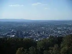 The Reading area from the Pagoda | |
 Seal | |
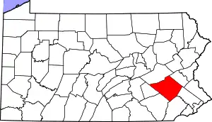 Location within the U.S. state of Pennsylvania | |
 Pennsylvania's location within the U.S. | |
| Coordinates: 40°25′N 75°56′W | |
| Country | |
| State | |
| Founded | March 11, 1752 |
| Named for | Berkshire |
| Seat | Reading |
| Largest city | Reading |
| Area | |
| • Total | 866 sq mi (2,240 km2) |
| • Land | 857 sq mi (2,220 km2) |
| • Water | 9.2 sq mi (24 km2) 1.1%% |
| Population | |
| • Estimate (2019) | 421,164 |
| • Density | 485/sq mi (187/km2) |
| Time zone | UTC−5 (Eastern) |
| • Summer (DST) | UTC−4 (EDT) |
| Congressional districts | 4th, 6th, 9th |
| Website | www |
| Designated | May 12, 1982[1] |
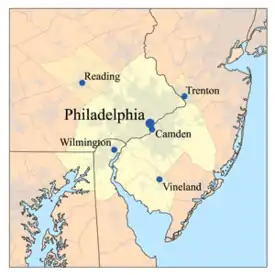
Berks County comprises the Reading, PA Metropolitan Statistical Area (MSA), which is also included in the Philadelphia-Reading-Camden, PA-NJ-DE-MD Combined Statistical Area. (CSA).
History
Reading developed during the 1740s when the inhabitants of northern Lancaster County sent several petitions requesting that a separate county be established. With the help of German immigrant Conrad Weiser, the county was formed on March 11, 1752, from parts of Chester County, Lancaster County, and Philadelphia County.[4]
It was named after the English county in which William Penn's family home lay, Berkshire, which is often abbreviated to Berks. Berks County began much larger than it is today. The northwestern parts of the county went to the founding of Northumberland County in 1772 and Schuylkill County in 1811, when it reached its current size. In 2005, Berks County was added to the Delaware Valley Planning Area due to a fast-growing population and close proximity to the other communities.
In 2016, former Strausstown borough merged with Upper Tulpehocken township. Strausstown is now a village within Upper Tulpehocken Township.
Geography
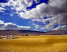
According to the U.S. Census Bureau, the county has a total area of 866 square miles (2,240 km2), of which 857 square miles (2,220 km2) is land and 9.2 square miles (24 km2) (1.1%) is water.[5] Most of the county is drained by the Schuylkill River, but an area in the northeast is drained by the Lehigh River via the Little Lehigh Creek and areas are drained by the Susquehanna River via the Swatara Creek in the northwest and the Conestoga River (which starts in Berks County between Morgantown and Elverson) in the extreme south. It has a humid continental climate (Dfa except for some Dfb on Blue Mountain at the northern boundary and on Mount Penn) and the hardiness zone is mostly 6b with 6a in some higher areas and 7a along the Schuylkill in the SE part of the county.
Major roads and highways
Adjacent counties
- Schuylkill County (north)
- Lehigh County (northeast)
- Montgomery County (east)
- Chester County (southeast)
- Lancaster County (southwest)
- Lebanon County (west)
National protected area
State protected area
Demographics
| Historical population | |||
|---|---|---|---|
| Census | Pop. | %± | |
| 1790 | 30,189 | — | |
| 1800 | 32,407 | 7.3% | |
| 1810 | 43,146 | 33.1% | |
| 1820 | 46,275 | 7.3% | |
| 1830 | 53,152 | 14.9% | |
| 1840 | 64,569 | 21.5% | |
| 1850 | 77,129 | 19.5% | |
| 1860 | 93,818 | 21.6% | |
| 1870 | 106,701 | 13.7% | |
| 1880 | 122,597 | 14.9% | |
| 1890 | 137,327 | 12.0% | |
| 1900 | 159,615 | 16.2% | |
| 1910 | 183,222 | 14.8% | |
| 1920 | 200,854 | 9.6% | |
| 1930 | 231,717 | 15.4% | |
| 1940 | 241,884 | 4.4% | |
| 1950 | 255,740 | 5.7% | |
| 1960 | 275,414 | 7.7% | |
| 1970 | 296,382 | 7.6% | |
| 1980 | 312,509 | 5.4% | |
| 1990 | 336,523 | 7.7% | |
| 2000 | 373,638 | 11.0% | |
| 2010 | 411,442 | 10.1% | |
| 2019 (est.) | 421,164 | [6] | 2.4% |
| U.S. Decennial Census[7] 1790–1960[8] 1900–1990[9] 1990–2000[10] 2010–2019[2] | |||
As of the 2010 census, the county was 76.9% White non-Hispanic, 4.9% Black or African American, 0.3% Native American, 1.3% Asian, and 2.5% were two or more races. 16.4% of the population was of Hispanic or Latino ancestry.[11] Historically there is a large Pennsylvania Dutch population. It is known as part of Pennsylvania Dutch Country.
As of the census[12] of 2010, there were 411,442 people, 154,356 households, and 106,532 families residing in the county. The population density was 479 people per square mile (184.9/km2). There were 164,827 housing units at an average density of 191.9 per square mile (74.1/km2).
According to Muninet Guide's 2010 analysis, the median household income for Berks County is $54,105.
There were 154,356 households, out of which 33.1% had children under the age of 18 living with them, 52.1% were married couples living together, 12.0% had a female householder with no husband present, and 31.0% were non-families. 24.5% of all households were made up of individuals, and 10.3% had someone living alone who was 65 years of age or older. The average household size was 2.59 and the average family size was 3.08.
In the county, the population was spread out, with 23.9% under the age of 18, 9.9% from 18 to 24, 24.4% from 25 to 44, 27.3% from 45 to 64, and 14.5% who were 65 years of age or older. The median age was 39.1 years. For every 100 females there were 95.90 males. For every 100 females age 18 and over, there were 92.70 males.
Berks County is home to an Old Order Mennonite community consisting of about 160 families, located in the East Penn Valley near Kutztown and Fleetwood.[13] The Old Order Mennonites first bought land in the area in 1949.[14] In 2012, Old Order Mennonites bought two large farms in the Oley Valley. The Old Order Mennonites in the area belong to the Groffdale Conference Mennonite Church and use the horse and buggy as transportation. There are several farms in the area belonging to the Old Order Mennonite community and meetinghouses are located near Kutztown and Fleetwood.[15]
Metropolitan and Combined Statistical Area
The United States Office of Management and Budget[16] has designated Berks County as the Reading, PA Metropolitan Statistical Area (MSA). As of the 2010 U.S. Census[17] the metropolitan area ranked 10th most populous in the State of Pennsylvania and the 128th most populous in the United States with a population of 413,491. Berks County is also a part of the larger Philadelphia-Reading-Camden, PA-NJ-DE-MD Combined Statistical Area (CSA), which combines the populations of Berks County as well as several counties around Philadelphia and in the states of Delaware, Maryland and New Jersey. The Combined Statistical Area is the largest in the State of Pennsylvania and 8th most populous in the United States with a population of 7,067,807.
Government
County Commissioners
.jpg.webp)
- Christian Leinbach, Chair Republican
- Kevin Barnhardt, Vice Chair Democrat
- Michael S. Rivera, Republican
Other county offices
- Clerk of Courts, James P. Troutman, Republican
- Controller, Sandy Graffius, Republican
- Coroner, Jonn M. Hollenbach (acting)
- District Attorney, John T. Adams, Democrat
- Prothonotary, Jonathan K. Del Collo, Republican
- Recorder of Deeds, Mary Kozak, Republican
- Register of Wills, Larry J. Medaglia Jr., Republican
- Sheriff, Eric Weaknecht, Republican
- Treasurer, A. Dennis Adams, Republican
State Senate[18]
State House of Representatives[18]
- Barry Jozwiak, Republican, Pennsylvania House of Representatives, District 5
- Jerry Knowles, Republican, Pennsylvania House of Representatives, District 124
- Mark Rozzi, Democrat, Pennsylvania House of Representatives, District 126
- Thomas R. Caltagirone, Democrat, Pennsylvania House of Representatives, District 127
- Mark Gillen, Republican, Pennsylvania House of Representatives, District 128
- Jim Cox, Republican, Pennsylvania House of Representatives, District 129
- David Maloney, Republican, Pennsylvania House of Representatives, District 130
- Ryan Mackenzie, Republican, Pennsylvania House of Representatives, District 134
- Gary Day, Republican, Pennsylvania House of Representatives, District 187
United States House of Representatives
Politics
As of October 24, 2016, there were 259,918 registered voters in Berks County.[19]
- Democratic: 120,282 (46.28%)
- Republican: 100,813 (38.79%)
- Other parties / No party: 38,823 (14.94%)
| Year | Republican | Democratic | Third parties |
|---|---|---|---|
| 2020 | 53.2% 109,926 | 45.0% 93,116 | 1.7% 3,511 |
| 2016 | 52.5% 96,626 | 42.6% 78,437 | 4.9% 9,022 |
| 2012 | 49.6% 84,702 | 48.6% 83,011 | 1.7% 2,963 |
| 2008 | 44.6% 80,513 | 53.8% 97,047 | 1.6% 2,951 |
| 2004 | 53.0% 87,122 | 46.4% 76,309 | 0.6% 1,056 |
| 2000 | 52.7% 71,273 | 43.7% 59,150 | 3.6% 4,874 |
| 1996 | 46.3% 56,289 | 41.0% 49,887 | 12.8% 15,542 |
| 1992 | 40.3% 52,939 | 35.0% 46,031 | 24.7% 32,437 |
| 1988 | 62.4% 70,153 | 36.5% 41,040 | 1.1% 1,251 |
| 1984 | 65.9% 74,605 | 33.5% 37,849 | 0.6% 691 |
| 1980 | 56.4% 60,576 | 33.9% 36,449 | 9.6% 10,360 |
| 1976 | 50.6% 54,452 | 47.4% 50,994 | 2.0% 2,107 |
| 1972 | 62.4% 66,172 | 34.5% 36,563 | 3.2% 3,392 |
| 1968 | 46.5% 50,623 | 45.8% 49,877 | 7.7% 8,424 |
| 1964 | 33.2% 36,726 | 66.4% 73,444 | 0.4% 476 |
| 1960 | 54.8% 61,743 | 44.9% 50,572 | 0.4% 391 |
| 1956 | 57.3% 57,258 | 42.4% 42,349 | 0.3% 320 |
| 1952 | 52.4% 51,720 | 46.5% 45,874 | 1.1% 1,074 |
| 1948 | 43.6% 35,608 | 52.7% 43,075 | 3.7% 3,043 |
| 1944 | 43.3% 35,274 | 53.9% 43,889 | 2.8% 2,247 |
| 1940 | 36.9% 32,111 | 61.3% 53,301 | 1.8% 1,530 |
| 1936 | 30.2% 26,699 | 64.4% 56,907 | 5.3% 4,721 |
| 1932 | 37.1% 27,073 | 40.8% 29,763 | 22.2% 16,187 |
| 1928 | 64.0% 47,073 | 25.8% 18,960 | 10.2% 7,481 |
| 1924 | 51.4% 28,186 | 31.4% 17,220 | 17.3% 9,487 |
| 1920 | 47.7% 22,221 | 39.4% 18,361 | 12.9% 6,009 |
| 1916 | 34.3% 11,937 | 55.4% 19,267 | 10.3% 3,565 |
| 1912 | 8.8% 3,032 | 47.5% 16,430 | 43.7% 15,098 |
| 1908 | 41.0% 13,642 | 52.3% 17,381 | 6.8% 2,245 |
| 1904 | 46.3% 15,539 | 48.7% 16,357 | 5.0% 1,683 |
| 1900 | 41.5% 13,952 | 56.6% 19,013 | 1.9% 628 |
| 1896 | 43.3% 14,318 | 54.7% 18,099 | 2.0% 665 |
| 1892 | 34.8% 10,077 | 64.2% 18,602 | 1.1% 312 |
| 1888 | 36.7% 10,626 | 62.5% 18,105 | 0.9% 261 |
| 1884 | 36.4% 9,587 | 62.6% 16,484 | 0.8% 226 |
| 1880 | 34.9% 9,225 | 64.3% 16,959 | 0.6% 181 |
The first time since 1964 that a Democrat carried Berks in a Presidential election occurred in November 2008, with Barack Obama receiving 53.9% of the vote to John McCain's 44.7%. The other three statewide winners (Rob McCord for treasurer, Jack Wagner for auditor general, and Tom Corbett for attorney general) also carried it.[21] While Republicans have controlled the commissioner majority most of the time and continue to control most county row offices, Democrats have become more competitive in Berks in recent years. In the 2012 Presidential election, Mitt Romney carried the county by approximately a one-percent margin, 49.6% to 48.6%, however, in 2016, Donald Trump carried Berks by a much larger margin of 52.9% to 42.7%.[22]
While Reading itself is heavily Democratic, the rural areas are strongly Republican.
Education
Colleges and universities
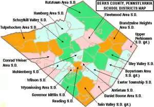
Public school districts
- Antietam School District
- Boyertown Area School District
- Brandywine Heights Area School District
- Conrad Weiser Area School District
- Daniel Boone Area School District
- Exeter Township School District
- Fleetwood Area School District
- Governor Mifflin School District
- Hamburg Area School District
- Kutztown Area School District
- Muhlenberg School District
- Oley Valley School District
- Reading School District
- Schuylkill Valley School District
- Tulpehocken Area School District
- Twin Valley School District
- Upper Perkiomen School District
- Wilson School District
- Wyomissing Area School District
Private high schools
- Berks Christian School in Birdsboro
- Blue Mountain Academy, a Seventh-day Adventist boarding school in Tilden Township
- Conestoga Christian School in Morgantown, Pennsylvania
- Fairview Christian School in Reading
- Gateway Christian School in Mertztown
- The King's Academy in Mohrsville
- Berks Catholic High School in Reading
- Lighthouse Christian Academy in Lyons
Technical and trade schools
- Berks Technical Institute
- Pace Institute
- Reading Hospital School of Nursing
- Berks Career and Technology Center (east campus in Oley, west campus in Leesport)
Arts and culture
The Reading Public Museum is an art, science, and history museum.
The Reading Buccaneers Drum and Bugle Corps are an all-age drum corps based in Berks County. The corps, founded in 1957, is a charter member Drum Corps Associates and an 11-time DCA World Champion.
Reading is home to one opera company, Berks Opera Company, founded in 2007 as Berks Opera Workshop. They were named Arts and Entertainment Newsmaker of the Year in 2015.
There are two Pennsylvania state parks and a Natural Area in Berks County.
- Nolde Forest Environmental Education Center is south of Reading on land once owned by Jacob Nolde, a prominent Reading businessman and Pennsylvania environmentalist.
- French Creek State Park, a former Recreational Demonstration Area, straddles the Berks and Chester County line.
- Ruth Zimmerman Natural Area, part of the William Penn Forest District in Oley.[23]
There are two Pennsylvania Historic Sites in Berks County.
The Old Morlatton Village in Douglassville is maintained by the Historic Preservation Trust of Berks County. The village is composed of four historic structures: White Horse Inn, George Douglass Mansion, Bridge keeper's House, and the Mouns Jones House, constructed in 1716, which is the oldest recorded building in the county.[24]
West Reading in home to the annual Art on the Avenue, which reached its 25th year in 2019.[25]
Media
Berks County has been home to several media sources including:
- Berks Community Television (BCTV)[26]
- Reading Eagle, a daily printed newspaper based in Reading, Pennsylvania
- WEEU, a local AM radio station
- WFMZ, a Local news channel that has offices in Berks County and covers South Eastern Pennsylvania
- WRFY-FM - (102.5 FM "Y102"), a commercial FM radio station licensed to serve Reading, Pennsylvania
Communities
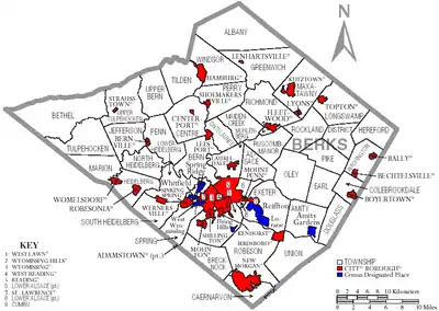
Under Pennsylvania law, there are four types of incorporated municipalities: cities, boroughs, townships, and towns. The following cities, boroughs and townships are located in Berks County:
City
- Reading (county seat)
Boroughs
- Adamstown (mostly in Lancaster County)
- Bally
- Bechtelsville
- Bernville
- Birdsboro
- Boyertown
- Centerport
- Fleetwood
- Hamburg
- Kenhorst
- Kutztown
- Laureldale
- Leesport
- Lenhartsville
- Lyons
- Mohnton
- Mount Penn
- New Morgan
- Robesonia
- St. Lawrence
- Shillington
- Shoemakersville
- Sinking Spring
- Topton
- Wernersville
- West Reading
- Womelsdorf
- Wyomissing
Townships
- Albany
- Alsace
- Amity
- Bern
- Bethel
- Brecknock
- Caernarvon
- Centre
- Colebrookdale
- Cumru
- District
- Douglass
- Earl
- Exeter
- Greenwich
- Heidelberg
- Hereford
- Jefferson
- Longswamp
- Lower Alsace
- Lower Heidelberg
- Maidencreek
- Marion
- Maxatawny
- Muhlenberg
- North Heidelberg
- Oley
- Ontelaunee
- Penn
- Perry
- Pike
- Richmond
- Robeson
- Rockland
- Ruscombmanor
- South Heidelberg
- Spring
- Tilden
- Tulpehocken
- Union
- Upper Bern
- Upper Tulpehocken
- Washington
- Windsor
Census-designated places
Census-designated places are geographical areas designated by the U.S. Census Bureau for the purposes of compiling demographic data. They are not actual jurisdictions under Pennsylvania law. Other unincorporated communities, such as villages, may be listed here as well.
- Alleghenyville
- Alsace Manor
- Amity Gardens
- Baumstown
- Bethel
- Blandon
- Bowers
- Colony Park
- Dauberville
- Douglassville
- Dryville
- Edenburg
- Flying Hills
- Fox Chase
- Frystown
- Gibraltar
- Gouglersville
- Greenfields
- Grill
- Hereford
- Hyde Park
- Jacksonwald
- Kempton
- Kutztown University
- Lincoln Park
- Lorane
- Mertztown
- Mohrsville
- Montrose Manor
- Morgantown
- Mount Aetna
- Muhlenberg Park
- New Berlinville
- New Jerusalem
- New Schaefferstown
- Oley
- Pennside
- Pennwyn
- Rehrersburg
- Reiffton
- Riverview Park
- Schubert
- Shartlesville
- South Temple
- Springmont
- Spring Ridge
- Stony Creek Mills
- Stouchsburg
- Temple
- Virginville
- Walnuttown
- West Hamburg
- West Lawn
- West Wyomissing
- Whitfield
Unincorporated communities
- Geigertown
- North Heidelberg
- Pine Swamp
- Plowville
- Pricetown
- Scarlets Mill
- State Hill
- Strausstown
- Brownsville
- Blue Marsh
- Leinbachs
- Wooltown
- Cacoosing
Population ranking
The population ranking of the following table is based on the 2010 census of Berks County.[17]
† county seat
CDP=census designated population
| Rank | City/Town/etc. | Municipal type | Population (2010 Census) |
|---|---|---|---|
| 1 | † Reading | City | 88,082 |
| 2 | Wyomissing | Borough | 10,461 |
| 3 | Blandon | CDP | 7,152 |
| 4 | Shillington | Borough | 5,273 |
| 5 | Birdsboro | Borough | 5,163 |
| 6 | Kutztown | Borough | 5,012 |
| 7 | Whitfield | CDP | 4,733 |
| 8 | Hamburg | Borough | 4,289 |
| 9 | Lorane | CDP | 4,236 |
| 10 | Pennside | CDP | 4,215 |
| 11 | West Reading | Borough | 4,212 |
| 12 | Reiffton | CDP | 4,178 |
| 13 | Fleetwood | Borough | 4,085 |
| 14 | Boyertown | Borough | 4,055 |
| 15 | Sinking Spring | Borough | 4,008 |
| 16 | Laureldale | Borough | 3,911 |
| 17 | West Wyomissing | CDP | 3,407 |
| 18 | Amity Gardens | CDP | 3,402 |
| 19 | Jacksonwald | CDP | 3,393 |
| 20 | Riverview Park | CDP | 3,380 |
| 21 | Mount Penn | Borough | 3,106 |
| 22 | Mohnton | Borough | 3,043 |
| 23 | Kutztown University | CDP | 2,918 |
| 24 | Kenhorst | Borough | 2,877 |
| 25 | Womelsdorf | Borough | 2,810 |
| 26 | Flying Hills | CDP | 2,568 |
| 27 | Hyde Park | CDP | 2,528 |
| 28 | Wernersville | Borough | 2,494 |
| 29 | Topton | Borough | 2,069 |
| 30 | Robesonia | Borough | 2,061 |
| 31 | West Hamburg | CDP | 1,979 |
| 32 | Leesport | Borough | 1,918 |
| 33 | Temple | CDP | 1,877 |
| 34 | St. Lawrence | Borough | 1,809 |
| 35 | West Lawn | CDP | 1,715 |
| 36 | Fox Chase | CDP | 1,622 |
| 37 | Lincoln Park | CDP | 1,615 |
| 38 | Grill | CDP | 1,468 |
| 39 | South Temple | CDP | 1,424 |
| 40 | Muhlenberg Park | CDP | 1,420 |
| 41 | Shoemakersville | Borough | 1,378 |
| 42 | New Berlinville | CDP | 1,368 |
| 43 | Oley | CDP | 1,282 |
| 44 | Greenfields | CDP | 1,170 |
| 45 | Alleghenyville | CDP | 1,134 |
| 46 | Bally | Borough | 1,090 |
| 47 | Colony Park | CDP | 1,076 |
| 48 | Stony Creek Mills | CDP | 1,045 |
| 49 | Spring Ridge | CDP | 1,003 |
| 50 | Bernville | Borough | 955 |
| 51 | Bechtelsville | Borough | 942 |
| 52 | Hereford | CDP | 930 |
| 53 | Dauberville | CDP | 848 |
| 54 | Morgantown | CDP | 826 |
| 55 | Pennwyn | CDP | 780 |
| 56 | Springmont | CDP | 724 |
| 57 | Edenburg | CDP | 681 |
| 58 | Gibraltar | CDP | 680 |
| 59 | Mertztown | CDP | 664 |
| 60 | New Jerusalem | CDP | 649 |
| 61 | Montrose Manor | CDP | 604 |
| 62 | Stouchsburg | CDP | 600 |
| 63 | Gouglersville | CDP | 548 |
| 64 | Bethel | CDP | 499 |
| 65 | Walnuttown | CDP | 484 |
| T-66 | Lyons | Borough | 478 |
| T-66 | Alsace Manor | CDP | 478 |
| 67 | Shartlesville | CDP | 455 |
| 68 | Douglassville | CDP | 448 |
| 69 | Baumstown | CDP | 422 |
| 70 | Dryville | CDP | 398 |
| 71 | Centerport | Borough | 387 |
| 72 | Mohrsville | CDP | 383 |
| 73 | Frystown | CDP | 380 |
| 74 | Mount Aetna | CDP | 354 |
| 75 | Strausstown | Borough | 342 |
| 76 | Bowers | CDP | 326 |
| 77 | Rehrersburg | CDP | 319 |
| 78 | Virginville | CDP | 309 |
| 79 | Schubert | CDP | 249 |
| 80 | New Schaefferstown | CDP | 223 |
| 81 | Kempton | CDP | 169 |
| 82 | Lenhartsville | Borough | 165 |
| 83 | New Morgan | Borough | 71 |
Notable people
- William Addams, congressman from Pennsylvania[27]
- Priscilla Ahn, folk musician and singer-songwriter
- Lonnie Walker, NBA player
- John Barrasso, US Senator
- Chad Billingsley, pitcher for the Philadelphia Phillies and Los Angeles Dodgers
- Douglas Carter Beane, playwright
- Daniel Boone, American pioneer, explorer, and frontiersman (1734–1820)
- Kenny Brightbill, NASCAR Driver
- Steve Burns, musician and former Blue's Clues host
- James Henry Carpenter (1846–1898), Civil War sailor, officer, founder of Carpenter Technology Corporation
- Jack Coggins, illustrator, author and artist, lived in Boyertown from 1948 to 2006
- Rocky Colavito, former Major League Baseball player
- Kerry Collins, professional football player (Panthers, Saints, Giants, Raiders, Titans, and Colts)
- Michael Constantine, actor, star of Room 222 and My Big Fat Greek Wedding
- Amy Cuddy, Harvard psychologist and TED Talks speaker
- Lisa Eichhorn, actress, moved to Reading as a child and graduated from Mt. Penn High School
- Carl Furillo (1922–1989), Former Brooklyn-Los Angeles Dodgers right-fielder
- John Henry Gilmore, Jr., professional football player (Saints, Bears, and Buccaneers)
- Jon Gosselin of the Gosselin family, Reality TV stars of Jon & Kate Plus 8
- Kate Gosselin of the Gosselin family, Reality TV stars of Jon & Kate Plus 8
- Keith Haring (1958–1990), artist
- Chad Henne, football player for the Miami Dolphins and University of Michigan
- Chris Hero, professional wrestler
- Joseph Hiester, governor of Pennsylvania 1820–1823
- Tommy Hinnershitz (1912–1999), auto racing pioneer
- Chad Hurley, co-founder of YouTube (attended Twin Valley and Albright College)
- Mildred Jordan (1901–1982), novelist
- Chip Kidd (born 1964), book jacket designer at Knopf Publishing Group[28]
- Abraham Lincoln (1744-1786), grandfather of 16th U.S. president Abraham Lincoln
- Matt Lytle (born 1975), professional football player
- Donyell Marshall, former NBA player and graduate of Reading High School
- James H. Maurer (1864-1944), Labor leader and two-time Vice Presidential nominee
- Kelly McGillis, actress, [Top Gun/Witness/The Accused]
- Gordon McKellen, Jr., former US figure skating champion and Hall of Fame member
- Morton L. Montgomery (1846–1933), Reading attorney and author of multiple history books about Berks County[29][30]
- Lenny Moore, NFL Hall of Fame
- Thomas Morris, Democratic politician, served in the United States Senate[31]
- Jillian Murray (b. June 4, 1989), model/actress
- Frederick Augustus Muhlenberg, architect, founder of Muhlenberg Greene Architects, American military and political leader 1887–1980
- Jacob Nolde, conservationist
- Bodo Otto, Senior Surgeon of the Continental Army during the American Revolution (1711–1787)
- William Sands, U.S. Medal of Honor winner (Civil War)[32]
- Martin Cruz Smith, novelist
- Carl Spaatz, World War II general
- Wallace Stevens, major American Modernist poet, October 2, 1879 – Cruz SAugust 2, 1955
- Taylor Swift (born 1989), Grammy Award-winning country/pop singer-songwriter
- Ross Tucker, professional football player
- John Updike, writer, 1932–2009
- Gus Yatron, former congressman from Pennsylvania
- Wayne Ellington, NBA Basketball Player
Footnotes
- "PHMC Historical Markers Search" (Searchable database). Pennsylvania Historical and Museum Commission. Commonwealth of Pennsylvania. Retrieved January 25, 2014.
- "State & County QuickFacts". United States Census Bureau. Archived from the original on July 7, 2011. Retrieved November 16, 2013.
- "Find a County". National Association of Counties. Archived from the original on May 31, 2011. Retrieved June 7, 2011.
- The Statutes at Large of Pennsylvania from 1682-1809, 18 vols. (Harrisburg, Pennsylvania: Wm. Stanley Ray, 1898), vol. 5 1744-1759, pages 133-140, 502-503, Chapter CCCXCII, "An Act for Erecting Part of the Counties Of Philadelphia, Chester and Lancaster into a Separate County," March 11, 1752, confirmed by the King in Council, May 10, 1753, creation of Berks County, digital images, Internet Archive (https://archive.org : July 26, 2018).
- "2010 Census Gazetteer Files". United States Census Bureau. August 22, 2012. Retrieved March 5, 2015.
- "Population and Housing Unit Estimates". Retrieved March 26, 2020.
- "U.S. Decennial Census". United States Census Bureau. Archived from the original on April 12, 2013. Retrieved March 5, 2015.
- "Historical Census Browser". University of Virginia Library. Retrieved March 5, 2015.
- Forstall, Richard L., ed. (March 24, 1995). "Population of Counties by Decennial Census: 1900 to 1990". United States Census Bureau. Retrieved March 5, 2015.
- "Census 2000 PHC-T-4. Ranking Tables for Counties: 1990 and 2000" (PDF). United States Census Bureau. April 2, 2001. Retrieved March 5, 2015.
- "Census 2010: Pennsylvania - USATODAY.com".
- http://pasdc.hbg.psu.edu/sdc/pasdc_files/census2010/Berks%20County.pdf
- Orth, Richard L.T. (August 23, 2018). "A Look Back in History Mennonite Plain Dutch families call Kutztown area home". BerksMont News. Retrieved September 26, 2019.
- Shaner, Richard (July 24, 2009). "Kutztown welcomes Old Order Mennonites in 1949". BerksMont News. Retrieved October 15, 2017.
- Orth, Richard L.T. (September 21, 2016). "A Look Back in History: The Old Order Mennonite Sect at Kutztown also preserving the Historic Oley Valley". BerksMont News. Retrieved October 15, 2017.
- "Office of Management and Budget". February 7, 2017.
- "Decennial Census by Decades". Archived from the original on December 6, 2013. Retrieved February 13, 2016.
- Center, Legislativate Data Processing. "Find Your Legislator". The official website for the Pennsylvania General Assembly. Retrieved May 23, 2017.
- Archived October 7, 2016, at the Wayback Machine Voting & Election Statistics
- Leip, David. "Dave Leip's Atlas of U.S. Presidential Elections". uselectionatlas.org.
- http://www.electionreturns.state.pa.us/ElectionsInformation.aspx?ElectionID=28 Archived November 16, 2012, at the Wayback Machine electionreturns.state.pa.us
- "Election Results". Retrieved November 16, 2016.
- http://www.dcnr.state.pa.us/cs/groups/public/documents/document/dcnr_20031119.pdf
- "Art on the Avenue 2018 Photos". BerksLuxury.com. June 16, 2018. Retrieved July 6, 2019.
- Community Television Review. National Federation of Local Cable Programmers. 1986. p. 23.
- Who Was Who in America, Historical Volume, 1607–1896. Chicago: Marquis Who's Who. 1963.
- "Reading Eagle". readingeagle.
- Montgomery, Morton L. Historical Sketch of Reading Artillerists: Read Upon the Occasion of Their 102d Anniversary in Metropolitan Hall, May 25, 1896. Chicago, Illinois: J.E. Norton & Company, 1897. OCLC 16413450
- Montgomery, Morton L. History of Berks County in Pennsylvania. Philadelphia, Pennsylvania: Everts, Peck & Richards, 1886. OCLC 11333191
- "Tolleson, Arizona". Biographical Directory of the United States Congress. Retrieved August 24, 2012.
- "Sands, William", in "Medal of Honor Recipients: Civil War (S-Z):. Washington, D.C.: U.S. Army Center of Military History, retrieved online October 6, 2018.
Further reading
- F.W. Balthaser, The Story of Berks County, Pennsylvania. Reading, PA: Reading Eagle Press, 1925.
- D.B. Brunner, The Indians of Berks County, Pa., Being a Summary of all the Tangible Records of the Aborigines of Berks County, with Cuts and Descriptions of the Varieties of Relics Found within the County. Reading, PA: Eagle Book Print, 1897.
- Morton L. Montgomery, History of Berks County in Pennsylvania. Philadelphia: Everts, Peck & Richards, 1886.
- Morton L. Montgomery, History of Berks County, Pennsylvania, in the Revolution, from 1774 to 1783. Reading, PA: C.F. Haage, printer, 1894.
- Morton L. Montgomery, Political Hand-Book of Berks County, Pennsylvania, 1752–1883. Reading, PA: B.F. Owen, 1883.
- Morton L. Montgomery, School history of Berks County in Pennsylvania. Philadelphia: J.B. Rodgers Printing Co., 1889.
- Kathy M. Scogna, "The Birth of a County — 1752,". Historical Review of Berks County, Winter 2001–02.
External links
| Wikimedia Commons has media related to Berks County, Pennsylvania. |
Places adjacent to Berks County, Pennsylvania | ||||||||||
|---|---|---|---|---|---|---|---|---|---|---|
| ||||||||||

| Counties |  | |
|---|---|---|
| Major cities | ||
| Cities and towns 50k-99k | ||
| Cities and towns 30k-50k | ||
| Authority control |
|---|