Bouc-Bel-Air
Bouc-Bel-Air (French pronunciation: [buk bɛl‿ɛʁ]; Occitan: Boc) is a commune in the Bouches-du-Rhône department in southern France. It is situated between Marseille, Gardanne and Aix-en-Provence. The old village is located at the summit of a small hill (a bouc in the regional language provençal).
Bouc-Bel-Air | |
|---|---|
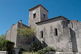 The church of Saint-André | |
.svg.png.webp) Coat of arms | |
Location of Bouc-Bel-Air 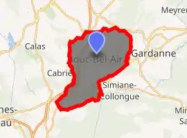
| |
 Bouc-Bel-Air  Bouc-Bel-Air | |
| Coordinates: 43°27′19″N 5°24′54″E | |
| Country | France |
| Region | Provence-Alpes-Côte d'Azur |
| Department | Bouches-du-Rhône |
| Arrondissement | Aix-en-Provence |
| Canton | Vitrolles |
| Intercommunality | Aix-Marseille-Provence |
| Government | |
| • Mayor (2020–2026) | Richard Mallie[1] |
| Area 1 | 21.75 km2 (8.40 sq mi) |
| Population (2017-01-01)[2] | 14,654 |
| • Density | 670/km2 (1,700/sq mi) |
| Time zone | UTC+01:00 (CET) |
| • Summer (DST) | UTC+02:00 (CEST) |
| INSEE/Postal code | 13015 /13320 |
| Elevation | 153–330 m (502–1,083 ft) (avg. 259 m or 850 ft) |
| 1 French Land Register data, which excludes lakes, ponds, glaciers > 1 km2 (0.386 sq mi or 247 acres) and river estuaries. | |
Population
|
|
Sights
Bouc-Bel-Air is typically in Provençal style, founded around a rock which formed the foundation of an old castle of the 7th century. It has a particularly nice view on several mountains among which the locally well known Sainte-Victoire.
History
Inhabited since very ancient times, its sites witness of Roman-Gallic settlings. Some of these sites date to the 7th century BC. Invasions of the Barbarians took place in the 7th century AD, the probable foundation date of the village. Birthplace (1797) of Adolphe Thiers, 2nd President of France (31 August 1871 – 24 May 1873)
References
- "Répertoire national des élus: les maires". data.gouv.fr, Plateforme ouverte des données publiques françaises (in French). 2 December 2020. Retrieved 7 December 2020.
- "Populations légales 2017". INSEE. Retrieved 6 January 2020.
External links
| Wikimedia Commons has media related to Bouc-Bel-Air. |
| Authority control |
|---|