Saint-Estève-Janson
Saint-Estève-Janson is a commune in the Bouches-du-Rhône department in southern France.
Saint-Estève-Janson | |
|---|---|
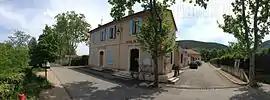 The town hall of Saint-Estève-Janson | |
.svg.png.webp) Coat of arms | |
Location of Saint-Estève-Janson 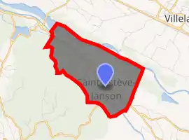
| |
 Saint-Estève-Janson  Saint-Estève-Janson | |
| Coordinates: 43°41′14″N 5°23′42″E | |
| Country | France |
| Region | Provence-Alpes-Côte d'Azur |
| Department | Bouches-du-Rhône |
| Arrondissement | Aix-en-Provence |
| Canton | Pélissanne |
| Intercommunality | Aix-Marseille-Provence |
| Government | |
| • Mayor (2008–2014) | Jean-Pierre Dufour |
| Area 1 | 8.65 km2 (3.34 sq mi) |
| Population (2017-01-01)[1] | 381 |
| • Density | 44/km2 (110/sq mi) |
| Time zone | UTC+01:00 (CET) |
| • Summer (DST) | UTC+02:00 (CEST) |
| INSEE/Postal code | 13093 /13610 |
| Elevation | 154–415 m (505–1,362 ft) (avg. 192 m or 630 ft) |
| 1 French Land Register data, which excludes lakes, ponds, glaciers > 1 km2 (0.386 sq mi or 247 acres) and river estuaries. | |
There is evidence of five hearths and reddened earth in the Escale Cave. These hearths have been dated to 200,000 BP.[2]
Population
| Year | Pop. | ±% |
|---|---|---|
| 1793 | 77 | — |
| 1800 | 67 | −13.0% |
| 1806 | 87 | +29.9% |
| 1821 | 92 | +5.7% |
| 1831 | 106 | +15.2% |
| 1836 | 111 | +4.7% |
| 1841 | 90 | −18.9% |
| 1846 | 82 | −8.9% |
| 1851 | 108 | +31.7% |
| 1856 | 135 | +25.0% |
| 1861 | 126 | −6.7% |
| 1866 | 139 | +10.3% |
| 1872 | 129 | −7.2% |
| 1876 | 158 | +22.5% |
| 1881 | 147 | −7.0% |
| 1886 | 115 | −21.8% |
| 1891 | 105 | −8.7% |
| 1896 | 105 | +0.0% |
| 1901 | 105 | +0.0% |
| 1906 | 102 | −2.9% |
| 1911 | 102 | +0.0% |
| 1921 | 84 | −17.6% |
| 1926 | 91 | +8.3% |
| 1931 | 103 | +13.2% |
| 1936 | 114 | +10.7% |
| 1946 | 106 | −7.0% |
| 1954 | 73 | −31.1% |
| 1962 | 137 | +87.7% |
| 1968 | 117 | −14.6% |
| 1975 | 130 | +11.1% |
| 1982 | 202 | +55.4% |
| 1990 | 234 | +15.8% |
| 1999 | 302 | +29.1% |
| 2008 | 339 | +12.3% |
References
- "Populations légales 2017". INSEE. Retrieved 6 January 2020.
- James, Steven R. (February 1989). "Hominid Use of Fire in the Lower and Middle Pleistocene: A Review of the Evidence" (PDF). Current Anthropology. University of Chicago Press. 30 (1): 1–26. doi:10.1086/203705. Retrieved 2012-04-04.
| Wikimedia Commons has media related to Saint-Estève-Janson. |
| Authority control |
|---|
This article is issued from Wikipedia. The text is licensed under Creative Commons - Attribution - Sharealike. Additional terms may apply for the media files.