Mallemort
Mallemort is a commune in the Bouches-du-Rhône department in southern France.
Mallemort | |
|---|---|
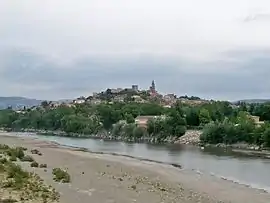 A general view of Mallemort, with the river in the foreground | |
.svg.png.webp) Coat of arms | |
Location of Mallemort 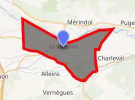
| |
 Mallemort  Mallemort | |
| Coordinates: 43°43′54″N 5°10′49″E | |
| Country | France |
| Region | Provence-Alpes-Côte d'Azur |
| Department | Bouches-du-Rhône |
| Arrondissement | Aix-en-Provence |
| Canton | Pélissanne |
| Intercommunality | Aix-Marseille-Provence |
| Government | |
| • Mayor (2008–2014) | Daniel Conte |
| Area 1 | 28.16 km2 (10.87 sq mi) |
| Population (2017-01-01)[1] | 6,019 |
| • Density | 210/km2 (550/sq mi) |
| Time zone | UTC+01:00 (CET) |
| • Summer (DST) | UTC+02:00 (CEST) |
| INSEE/Postal code | 13053 /13370 |
| Elevation | 99–225 m (325–738 ft) (avg. 150 m or 490 ft) |
| 1 French Land Register data, which excludes lakes, ponds, glaciers > 1 km2 (0.386 sq mi or 247 acres) and river estuaries. | |
Mallemort is a quiet town located on the river Durance, south of the Luberon mountain range. The town itself is 10 km (6.2 mi) off the Autoroute du Soleil (the main motorway to the South and Marseille), within easy reach of Arles, Saint-Rémy, and Salon-de-Provence.
Population
|
|
References
- "Populations légales 2017". INSEE. Retrieved 6 January 2020.
| Wikimedia Commons has media related to Mallemort. |
| Authority control |
|---|
This article is issued from Wikipedia. The text is licensed under Creative Commons - Attribution - Sharealike. Additional terms may apply for the media files.