Boyd Strait
Boyd Strait is the 40-kilometre (25 mi) wide strait lying between Snow Island and Smith Island in the South Shetland Islands, Antarctica, and linking Drake Passage and the Bransfield Strait.
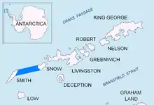
Location of Boyd Strait in the South Shetland Islands.
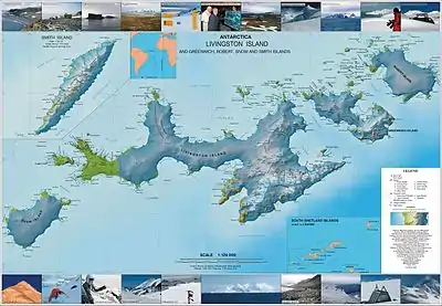
Topographic map of Livingston Island, Greenwich, Robert, Snow and Smith Islands.
The strait was named in 1823 by a British expedition under James Weddell for Captain David Boyd, Royal Navy.
Location
Boyd Strait is located at 62°50′S 62°00′W. British mapping in 1823 and 1930-1931.
Maps
- Chart of South Shetland including Coronation Island, &c. from the exploration of the sloop Dove in the years 1821 and 1822 by George Powell Commander of the same. Scale ca. 1:200000. London: Laurie, 1822.
- South Shetland Islands : Map 3. Scale 1:200000. Cambridge: British Antarctic Survey, 2008.
References
- Boyd Strait. SCAR Composite Antarctic Gazetteer
 This article incorporates public domain material from the United States Geological Survey document: "Boyd Strait". (content from the Geographic Names Information System)
| General |
| .svg.png.webp) |
|---|---|---|
| Regions | ||
| Waterways | ||
| Famous explorers | ||
This article is issued from Wikipedia. The text is licensed under Creative Commons - Attribution - Sharealike. Additional terms may apply for the media files.
