Gibbs Island (South Shetland Islands)
Gibbs Island lies 25 km (16 mi) south-west of Elephant Island in the South Shetland Islands of Antarctica. James Weddell, whose chart of the islands appeared in 1825, was apparently the first to use the current name.
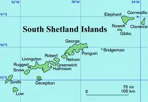 A map of the South Shetland Islands | |
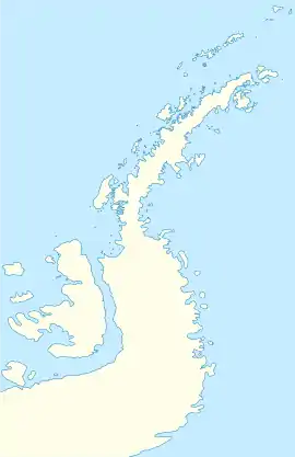 Gibbs Island Location of Gibbs Island  Gibbs Island Gibbs Island (Antarctica) | |
| Geography | |
|---|---|
| Location | Antarctica |
| Coordinates | 61°28′S 055°34′W |
| Archipelago | South Shetland Islands |
| Area | 22 km2 (8.5 sq mi) |
| Length | 13 km (8.1 mi) |
| Width | 2 km (1.2 mi) |
| Administration | |
| Administered under the Antarctic Treaty System | |
| Demographics | |
| Population | Uninhabited |
| Ethnic groups | None |
Description
Gibbs is a slender, east-west aligned island, some 13 km (8.1 mi) long, 2 km (1.2 mi) wide and 22 km2 (8 sq mi) in area. It is bordered to the south by Bransfield Strait and to the north by the Loper Channel. The isthmus of The Spit joins the main part of Gibbs Island in the west to Furse Peninsula in the east.[1]
Important Bird Area
A 369 ha tract of land comprising Furse Peninsula, The Spit and a small ice-free area on Gibbs Island west of The Spit has been identified as an Important Bird Area (IBA) by BirdLife International because it supports breeding colonies of about 1700 pairs of macaroni and 190 pairs of chinstrap penguins, as well as over 18,000 pairs of southern fulmars.[1]
See also
- List of Antarctic and subantarctic islands
References
- "Gibbs Island East". BirdLife data zone: Important Bird Areas. BirdLife International. 2012. Archived from the original on 2007-07-10. Retrieved 2012-12-30.
| General |
| .svg.png.webp) |
|---|---|---|
| Regions | ||
| Waterways | ||
| Famous explorers | ||