Bulungkol
Bulungkol Township[3][4]:192[5][6][7] (بۇلۇڭكۆل يېزىسى;[8][9] Chinese: 布伦口乡; pinyin: Bùlúnkǒu Xiāng) is a township of Akto County in Xinjiang Uygur Autonomous Region, China. Located in the middle west of the county, the township covers an area of 4,585 square kilometers with a population of 7,133 (as of 2017). It has 5 administrative villages under its jurisdiction. Its seat is at Bulungkol Village (布伦口村).[1]
Bulungkol
بۇلۇڭكۆل يېزىسى 布伦口乡 Bulunkou | |
|---|---|
 Bulungkol Township | |
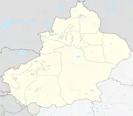 Bulungkol Location of the township | |
| Coordinates: 38.6639251878°N 74.9515647176°E | |
| Country | People's Republic of China |
| Autonomous region | Xinjiang |
| Prefecture | Kizilsu |
| County | Akto |
| Area | |
| • Total | 4,585 km2 (1,770 sq mi) |
| Population (2017) | |
| • Total | 7,133 |
| [1] | |
| Ethnic groups | |
| • Major ethnic groups | Kyrgyz[2] |
| Time zone | UTC+8 (China Standard Time) |
| postal code | 845556 |
| Area code(s) | 653022 206 |
| Website | www.xjakt.gov.cn |
Name
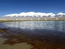
The name of Bulungkol is from Kyrgyz language, meaning "lake in the corner" (角落里的湖泊), it was named after the Bulungkol Lake (布伦口湖) in its territory.[10][11]
History
In 1955, Bulungkol was transferred to Akto County from Tashkurgan County.[4]:193
In 1959, Bulungkol Commune (布伦口公社) was established.[12]
In 1967, Bulungkol Commune was renamed Fanxiu Commune ('anti-revisionism commune' 反修公社).[12]
In 1984, Fanxiu Commune became Bulungkol Township.[12]
Geography
.jpg.webp)
The township of Bulungkol is located on the Pamir Plateau, southwest of Akto County, between east longitude 74°36′- 75°37′and north latitude 38°10′- 38°58′. It is bordered by Barin Township and Kirzilto Township to the east, by Oytak Town to the north, by Muji Township to the west, by Tashkurgan County and the Republic of Tajikistan to the south. The township has a boundary line of 82 kilometers with 8 mountain passes connecting Tajikistan. The seat of the township is 140 kilometers away from the county seat. The area of grassland is 31,290 hectares, and the area of artificial grassland is 665.15 hectares.
Bulungkol Township has an alpine climate with an average annual temperature of 0.7 ℃, an average temperature of January –12.1 ℃, an average temperature of 12.2 ℃ in July, an annual precipitation of 150 to 200 mm, and a frost-free period of 90 to 100 days. The mountains and valleys in the territory are interlaced, with an altitude of 3,000 to 4,500 meters. The highest point is 7,719 meters at the peak of Kongurtagh Tiube. The Kongur - Mustag mountains are cascaded, the gullies are horizontal and vertical, and the peaks are covered with snow all year round. There are large areas of glaciers, the Gez River (盖孜河) and the Kangxiwar River (康西瓦尔河) originate from this glaciers. There are lakes and springs under the mountains with beautiful scenery, cold weather and more precipitation. There are rare wild animals such as snowcock, snow leopard, procapra przewalskii and argali, and there are rare vegetation such as sand holly and snow lotus. The mineral resources mainly include metal mines such as iron, gold and copper, and non-metallic minerals such as diamond, granite and muscovite. The main tourist attractions are Karakul Lake (national tourist attraction) and Baisha Mountain (白沙山).[13][1]
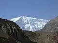
 South face of Kongur Tagh
 Kongur Tagh
 Kongur Tagh
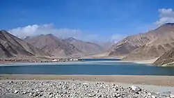
 Gez Valley
.jpg.webp)
 Bulungkol Lake
Bulungkol Lake.jpg.webp) Bulungkol Lake
Bulungkol Lake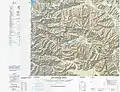 Map of the region including Bulungkol (DMA, 1988)
Administrative divisions
The township has 5 administration villages.[14][2]
- Bulungkol (بۇلۇڭكۆل كەنت,[8] Bulunkou 布伦口村)
- Gez (Gaizi, Gaizicun;[15] 盖孜村) 38°45′58″N 075°18′52″E
- Qiake'er'aigele (Qiake’er Aigelecun;[16] 恰克尔艾格勒村) 38°47′32″N 074°56′28″E
- Subax (Subashi; 苏巴什村), location of Kongur Tagh (公格尔九别峰)
- Tuogayi (托喀依村)
- Qarjayit (恰尔加依特)
Demographics
| Year | Pop. | ±% p.a. |
|---|---|---|
| 2000 | 5,490 | — |
| 2010 | 6,922 | +2.34% |
| [12] | ||
As of 1997, the population of Bulungkol Township was 99.9% Kyrgyz.[2]
Economy
Animal husbandry is the main component of Bulungkol's economy, producing Subashi Large-tailed Sheep (苏巴什大尾羊). Mineral resources include iron, copper, spodumene, beryl, muscovite and others.[4]:193
Transportation
- China National Highway 314,[4]:193 part of the Karakoram Highway[12]
See also
References
- 布伦口乡(概况). xjakt.gov.cn. 2018-06-04. Retrieved 2019-07-07.
- 1997年阿克陶县行政区划 [1997 Akto County Administrative Divisions] (in Chinese). XZQH.org. 31 December 2010. Retrieved 17 September 2020.
布伦口乡 1959年成立布伦口公社,1967年更名反修公社,1984年改设布伦口乡。位于县城西南220千米,为山区。面积4114平方千米,人口0.6万,其中柯尔克孜族占99.9%。中巴公路从乡中心地带穿过,辖布伦库勒、苏巴什、恰克尔艾格勒、盖孜、托喀依5个行政村。古迹有玉奇喀帕古驿站遗址及阿克白依权古墓。
- huaxia, ed. (24 September 2019). "Xinhua Headlines: 70 years on, China's Xinjiang embraces future with vitality, stability". Xinhua News Agency. Retrieved 17 September 2020.
Aerial photo taken on June 14, 2019 shows the construction site of a highway linking Bulungkol with Kunjirap in northwest China's Xinjiang Uygur Autonomous Region.
- Xie Yuzhong 解玉忠 (2003). 地名中的新疆 (in Chinese). Ürümqi: 新疆人民出版社. ISBN 7-228-08004-1.
布伦口 Bulungkol
- Zhong Xingqi 钟兴麒, ed. (July 2008). 西域地名考录 (in Chinese). Beijing: 国家图书馆出版社. p. 162. ISBN 978-7-5013-3628-9.
布伦口 bù lún kǒu Bulungköl
- Eset Sulaiman, Roseanne Gerin (2017). "Authorities Urge Kyrgyz Herdsmen to Spy on Uyghurs in China's Xinjiang". Radio Free Asia. Translated by Mamatjan Juma.
Authorities are promoting the letter mainly in villages in border areas, such as Muji and Bulungkol in Akto (in Chinese, Aketao) county, he said.
- Bulungkol (Approved - N) at GEOnet Names Server, United States National Geospatial-Intelligence Agency
- Amangul Abdurrahman ئامانگۈل ئابدۇراخمان, ed. (4 March 2020). جەنۇبىي شىنجاڭدىكى دېھقانلار ئالدىراش بولۇپ كەتتى. Xinjiang Daily. Archived from the original on 18 September 2020. Retrieved 17 September 2020 – via Internet Archive.
بۇلۇڭكۆل يېزىسى بۇلۇڭكۆل كەنت
- بۇلۇڭكۆل (Variant Non-Roman Script - VS) at GEOnet Names Server, United States National Geospatial-Intelligence Agency
- 布伦口的灯光. xjdaily.com.cn. 2019-07-06. Retrieved 2019-11-07.; 它是新疆的千湖之乡,境内的冰山和湖泊是著名的旅游胜地. baidu.com. 2018-08-03. Retrieved 2019-11-07.
- 阿克陶县行政区划和居民地名称. xjkz.gov.cn. 2018-05-04. Retrieved 2019-11-08.
- 阿克陶县历史沿革. XZQH.org (in Chinese). 29 January 2015. Archived from the original on 19 August 2019. Retrieved 18 September 2020.
2000年第五次人口普查,阿克陶县常住总人口163024人,其中:{...}布仑口乡5490人、2010年第六次人口普查,阿克陶县常住总人口199065人,其中:{...}布伦口乡6922人,
- 布伦口乡(概况). qianxi123.com. 2018-08-12. Retrieved 2019-11-08.
- 2018年阿克陶县布伦口乡行政区划代码. National Bureau of Statistics of China. 2018-10-31. Retrieved 2019-11-07.
- Gaizicun (Approved - N) at GEOnet Names Server, United States National Geospatial-Intelligence Agency
- Qiake’er Aigelecun (Approved - N) at GEOnet Names Server, United States National Geospatial-Intelligence Agency
| Look up Bulungkol in Wiktionary, the free dictionary. |
