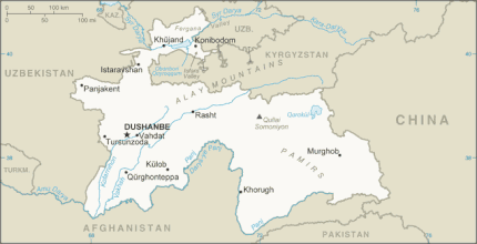
China–Tajikistan border
The China–Tajikistan border is 477 km (296 mi)[1] in length and runs from the tripoint with Kyrgyzstan following a roughly north–south line across various mountain ridges and peaks of the Pamir range down to the tripoint with Afghanistan.[2] The border divides Murghob District, Gorno-Badakhshan Autonomous Region in Tajikistan from Akto County, Kizilsu Kyrgyz Autonomous Prefecture (to the north) and Taxkorgan Tajik Autonomous County, Kashgar Prefecture (to the south) in Xinjiang Uygur Autonomous Region, China.
History
The origins of the border date from the mid-19th century, when the Russian empire expanded into Central Asia and established control over the Lake Zaysan region. The establishment of the border between the Russian Empire and the Qing Empire, not too different from today's Sino-Kazakh/Kyrgyz/Tajik border was provided for in the Convention of Peking of 1860;[3][4] the actual border line pursuant to the convention was drawn by the Treaty of Tarbagatai (1864) and the Treaty of Uliassuhai (1870), leaving Lake Zaysan on the Russian side.[5][6][4] The Qing Empire's military presence in the Irtysh basin crumbled during the Dungan revolt (1862–77). After the failure of the rebellion and the reconquest of Xinjiang by Zuo Zongtang, the border between the Russian and the Qing empires in the Ili River basin was further slightly readjusted, in Russia's favour, by the Treaty of Saint Petersburg (1881) and a series of later protocols.[4] In 1915 an agreement was signed more precisely delimiting the border between the Ili Valley and the Dzungarian Alatau region.[4] The southernmost section of the frontier (i.e. roughly the southern half of the modern China–Tajikistan border) remained undemarcated, owing partly to the ongoing rivalry between Britain and Russia for dominance in Central Asia known as the Great Game; eventually the two agreed that Afghanistan would remain an independent buffer state between them, with Afghanistan's Wakhan Corridor being created in 1895.[4] China was not a party to these agreements and hence the southernmost section of the China-Russia boundary remained undefined.[4][7] When Tajikistan became independent in 1991 it inherited a section of the China-USSR frontier. That boundary followed the drainage basin divide between the Amu Darya and the Yarkand River until reaching Markansu.[4]:10
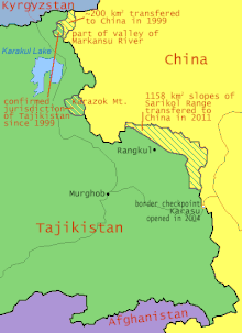
In 2011, Tajikistan ratified a 1999 deal (and a 2002 supplementary agreement) to cede 200 km2 (77 sq mi) and 1,122 km2 (433 sq mi) respectively[8] of land in the Pamir Mountains to the People's Republic of China, ending a 130-year dispute. In the treaty, China also relinquished claims to over 28,000 km2 (11,000 sq mi) of Tajikistani territory.[9][10][8] The Republic of China had historically made similar claims in the area.[11] Tajik attitudes toward the boundary treaty varied significantly among different interest groups, ranging from overt opposition to overt support.[12]
In July 2020, repeated publication of an article by Cho Yao Lu in Chinese domestic media which suggested Tajikistan should give China more land was met with sharp disapproval in Tajikistan and Russia.[13][14][15][16][17]
Geography
A point north of the Markansu River (瑪爾坎蘇河) on the China–Tajikistan border is the westernmost point of China.
The border's southern terminus is found at the Afghanistan-China-Tajikistan tripoint on Povalo-Shveikovskogo Peak[18][19] (Chinese: 波万洛什维科夫斯基峰[20]; pinyin: Bōwànluò Shíwéikēfūsījī Fēng) / Kokrash Kol Peak (Kekelaqukaole Peak; Chinese: 克克拉去考勒峰[21]; pinyin: Kèkèlāqùkǎolè Fēng)[22] which is also the eastern end of the Afghanistan-Tajikistan border and the northern end of the Afghanistan-China border as well as the easternmost point of Afghanistan.
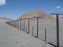
Border crossings
The Karasu Port of Entry at the Kulma Pass (4,362.7 m (14,313 ft)) is the only modern day border crossing between China and Tajikistan.[23] Historically, two passes further south along the border, Nezatash Pass and Beyik Pass, have also been traversed. Northwest of Kulma Pass is the Uzbel/Kyzyl-Dzhiik Pass (also known as Uzbel Shankou,[24] Pereval Kyzyl-Dzhiik,[25][26] Wuzibieli Pass[22] (乌孜别里山口[27]), Kizil Jik Dawan, Kizöl-jiik Pass, K’o-tse-lo-chi-k’o Shan-k’ou, Qizil Jik Dāwan, Utzupieli Pass and Wu-tzu-pieh-li Shan-k’ou[26]).[22]
Historical maps
Historical English-language maps of the China-USSR (Tajik SSR) border area, mid to late 20th century, and historical maps including the pre-2011 China–Tajikistan border:
_p61_PLATE19._SINKIANG_(14597194848).jpg.webp) Map including the China-Russia border in the modern-day Tajikistan area (1917)
Map including the China-Russia border in the modern-day Tajikistan area (1917)
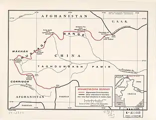 Map of Afghanistan-China Boundary (with the Afghanistan-China-USSR (Tajik SSR) tripoint labeled as PEAK POVALO SHVEIKOVSKI 5698 (18694)) (1969)[lower-alpha 2]
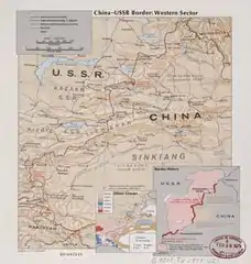 Map of the western China-USSR border showing the Pamir area (41,000 km2 (16,000 sq mi)) claimed by China
"This section shown as "Indefinite" on Chinese maps, "Definite" on Russian maps. Based on 1895 Anglo-Russian treaty." (1977) Border region (DMA, 1980)[lower-alpha 3]
 Northern/western section of the border (DMA, 1981)[lower-alpha 4]
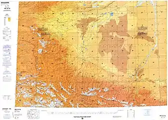 Southern/eastern section of the border (DMA, 1984)[lower-alpha 5]
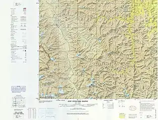 Map including part of the China-USSR (Tajik SSR) border near Taxkorgan (T'a-shih-k'u-erh-kan) (DMA, 1985)
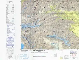 Portion of the China-USSR (Tajik SSR) border (DMA, 1989)
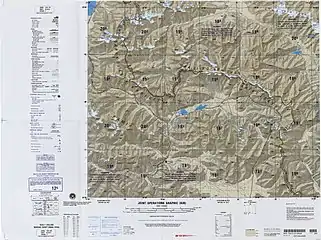 Portion of the China-USSR (Tajik SSR) border (DMA, 1988)[lower-alpha 6]
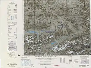 Portion of the China-Tajikistan border (labeled "BOUNDARY IN DISPUTE") including the tripoint with Afghanistan (DMA, 1992)[lower-alpha 7]
 Map of Tajikistan showing the border with China and road through Uzbel/Kyzyl-Dzhiik Pass (2001)
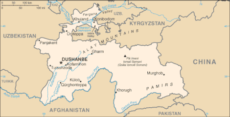 Historical map of Tajikistan showing the border with China
See also
Notes
- From map: "DELINEATION OF INTERNATIONAL BOUNDARIES MUST NOT BE CONSIDERED AUTHORITATIVE"
- From map: "NAMES AND BOUNDARY REPRESENTATION ARE NOT NECESSARILY AUTHORITATIVE"
- From map: "The representation of international boundaries is not necessarily authoritative."
- From map: "The representation of international boundaries is not necessarily authoritative"
- From map: "The representation of international boundaries is not necessarily authoritative"
- From map: "THE REPRESENTATION OF INTERNATIONAL BOUNDARIES IS NOT NECESSARILY AUTHORITATIVE."
- From map: "BOUNDARY REPRESENTATION IS NOT NECESSARILY AUTHORITATIVE."
References
| Wikimedia Commons has media related to China-Tajikistan border. |
| Chinese Wikisource has original text related to this article: |
| Chinese Wikisource has original text related to this article: |
- "FIELD LISTING :: LAND BOUNDARIES". The World Factbook. Retrieved 30 January 2020.
China total: 22,457 km border countries (15):{...}Tajikistan 477 km, {...}Tajikistan total: 4,130 km border countries (4): {...}China 477 km, {...
} - CIA World Factbook - Tajikistan, 23 September 2018
- Articles 2 and 3 in the Russian text of the treaty
- International Boundary Study No. 64 – China-USSR Boundary (PDF), 13 February 1978, archived from the original (PDF) on 17 August 2014, retrieved 23 September 2018
- (See the map)
- The Lost Frontier: the treaty maps that changed Qing's northwestern boundaries
- CIA (1977). "China Oil Production Prospects". p. 2 – via Internet Archive. (Note: In the map, the southern part of the border is drawn with a dotted line, whereas the northern part of the border is drawn with a solid line.)
- Alex Sodiqov (24 January 2011). "Tajikistan cedes disputed land to China". Eurasia Daily Monitor. Jamestown Foundation. 8 (16). Retrieved 23 September 2018.
On January 12, the lower house of the Tajik parliament voted to ratify the 2002 border demarcation agreement, handing over 1,122 square kilometers (433 square miles) of mountainous land in the remote Pamir Mountains (www.asiaplus.tj, January 12). The ceded land represents about 0.8 percent of the country’s total area of 143,100 square kilometers (55,250 square miles).{...}At the time of independence, Tajikistan inherited three disputed border segments, constituting about 28,500 square kilometers (11,000 square miles), which China and the Soviet Union had been unable to resolve. In 1999, Tajikistan and China signed a border demarcation agreement, defining the border in two of the three segments. Under the 1999 deal, Dushanbe ceded about 200 square kilometers (77 square miles) of land to Beijing (http://www.ca-oasis.info/oasis/?jrn=109&id=817).
- "Tajikistan cedes land to China". BBC News. 13 January 2011. Retrieved 3 May 2016.
- "China's area increases by 1000 sq km". Times of India. 12 January 2011. Archived from the original on 2011-01-16. Retrieved 3 May 2016.
- 臺灣歷史地圖 增訂版 [Taiwan Historical Maps, Expanded and Revised Edition] (in Chinese). Taipei: National Museum of Taiwan History. February 2018. p. 165. ISBN 978-986-05-5274-4. (In the map 外省來源地分布圖1966年, the border of Sinkiang (Xinjiang; 新疆省) includes an area approximately similar to the Pamir area in the map China-USSR: Border Western Sector.)
- Assel Bitabarova (January 2015). "Contested Views of Contested Territories: How Tajik Society Views the Tajik-Chinese Border Settlement" (PDF). Eurasia Border Review. Retrieved 21 January 2020.
- Paul Goble (30 July 2020). "Beijing Implies Tajikistan's Pamir Region Should Be Returned to China". Eurasia Daily Monitor. 17 (112). Retrieved 7 August 2020 – via Jamestown Foundation.
- "Now, China eyes Pamir region in Tajikistan". WION. 4 August 2020. Retrieved 7 August 2020.
'Pamir was outside China [for] 128 years due to the pressure of world powers', these are the words of Cho Yau Lu.
- Yau Tsz Yan (3 August 2020). "China business briefing: Unclear borders, uneasy neighbors". Eurasianet. Retrieved 7 August 2020.
Days later, an article appeared in Chinese news outlets claiming that Tajikistan’s Pamir mountains historically belonged to China and should be returned. Though the article was penned by a nationalist historian and does not appear to be a veiled hint from the Party, the message hit Dushanbe in a sensitive spot. Tajik officials are perennially concerned about the Pamirs, a region where they have tenuous authority over the local population.
- "Expansionist China eyes Tajik territory".
- Пекин претендует на Памир? Что пишут китайские СМИ о таджиках и о Таджикистане?.
- Kamoludin Abdullaev (2018). Historical Dictionary of Tajikistan (3 ed.). Rowman & Littlefield. p. 92. ISBN 9781538102527 – via Google Books.
CHINA-TAJIK BORDER.{...}This mountainous boundary runs along the Sarikol mountain range in eastern Tajikistan, reaching in Pamir the Afghan border at the Povalo-Shveikovskogo peak (5,543 meters above sea level).
- "NJ 43 Su-fu [U.S.S.R., China, Afghanistan, Pakistan, State of Jammu and Kashmir] Series 1301, Edition 5-AMS". Washington, D. C.: Army Map Service. March 1967 – via Perry–Castañeda Library Map Collection.
Pik Povalo-Shveikovskogo
- 中华人民共和国和阿富汗王国边界条约 (in Chinese). 22 November 1963 – via Wikisource.
到高程为5698米的克克拉去考勒峰(阿方图称波万洛什维科夫斯基峰)。
- 阿富汗 (in Chinese). State Ethnic Affairs Commission. 6 July 2004. Archived from the original on 4 December 2008.
中阿边界{...}南起中、巴、阿3国交界处的5587山峰,沿穆斯塔格山脉分水岭北行至克克拉去考勒峰。
- "China Report Political, Sociological and Military Affaris No. 363" (PDF). United States Joint Publications Research Service. 18 November 1982. p. 1. Retrieved 11 January 2020 – via Defense Technical Information Center.
If we open up the Atlas of the People's Republic of China we will find that the region of the Pamir, the western extremity of Xinjiang, from the Wuzibieli [Uzbel] Pass1 to the south down to the Kekelaqukaole Peak (which the Soviet Russians call "Pavel Shveikovsky Peak") is designated as a not limited area.
- Caravanistan - Tajikistan border crossings, retrieved 23 September 2018
- Uzbel Shankou (Approved - N) at GEOnet Names Server, United States National Geospatial-Intelligence Agency
- Pereval Kyzyl-Dzhiik (Approved - N) at GEOnet Names Server, United States National Geospatial-Intelligence Agency
- "China-USSR border, western sector" – via Library of Congress.
Wu-tzu-pieh-li Shan-k'ou (Pereval Kyzyl-Dzhiik)
- 夏征农; 陈至立, eds. (September 2009). 辞海:第六版彩图本 [Cihai (Sixth Edition in Color)] (in Chinese). 上海. Shanghai: 上海辞书出版社. Shanghai Lexicographical Publishing House. p. 2187. ISBN 9787532628599.
乌孜别里山口
!["NJ 43 Su-fu [U.S.S.R., China, Afghanistan, Pakistan, State of Jammu and Kashmir] Series 1301, Edition 5-AMS"](http://legacy.lib.utexas.edu/maps/imw/txu-oclc-6654394-nj-43-5th-ed.jpg)