Canton, Minnesota
Canton is a city in Fillmore County, Minnesota, United States. The population was 346 at the 2010 census.[6]
Canton | |
|---|---|
 | |
 Location of Canton, Minnesota | |
| Coordinates: 43°31′48″N 91°55′47″W | |
| Country | United States |
| State | Minnesota |
| County | Fillmore |
| Area | |
| • Total | 1.03 sq mi (2.67 km2) |
| • Land | 1.03 sq mi (2.67 km2) |
| • Water | 0.00 sq mi (0.00 km2) |
| Elevation | 1,345 ft (410 m) |
| Population | |
| • Total | 346 |
| • Estimate (2019)[3] | 344 |
| • Density | 333.66/sq mi (128.88/km2) |
| Time zone | UTC-6 (Central (CST)) |
| • Summer (DST) | UTC-5 (CDT) |
| ZIP code | 55922 |
| Area code(s) | 507 |
| FIPS code | 27-09802[4] |
| GNIS feature ID | 2393733[5] |
History
A post office called Canton has been in operation since 1882.[7] Canton was incorporated in 1887.[8] The city was named after Canton, Ohio.[8]
Geography
According to the United States Census Bureau, the city has a total area of 1.00 square mile (2.59 km2), all of it land.[9]
Demographics
| Historical population | |||
|---|---|---|---|
| Census | Pop. | %± | |
| 1890 | 281 | — | |
| 1900 | 312 | 11.0% | |
| 1910 | 345 | 10.6% | |
| 1920 | 365 | 5.8% | |
| 1930 | 385 | 5.5% | |
| 1940 | 421 | 9.4% | |
| 1950 | 459 | 9.0% | |
| 1960 | 467 | 1.7% | |
| 1970 | 391 | −16.3% | |
| 1980 | 386 | −1.3% | |
| 1990 | 362 | −6.2% | |
| 2000 | 343 | −5.2% | |
| 2010 | 346 | 0.9% | |
| 2019 (est.) | 344 | [3] | −0.6% |
| U.S. Decennial Census[10] | |||
2010 census
As of the census[2] of 2010, there were 346 people, 162 households, and 88 families living in the city. The population density was 346.0 inhabitants per square mile (133.6/km2). There were 177 housing units at an average density of 177.0 per square mile (68.3/km2). The racial makeup of the city was 99.7% White and 0.3% from two or more races. Hispanic or Latino of any race were 0.6% of the population.
There were 162 households, of which 25.3% had children under the age of 18 living with them, 43.2% were married couples living together, 7.4% had a female householder with no husband present, 3.7% had a male householder with no wife present, and 45.7% were non-families. 40.1% of all households were made up of individuals, and 19.8% had someone living alone who was 65 years of age or older. The average household size was 2.14 and the average family size was 2.88.
The median age in the city was 43.3 years. 23.4% of residents were under the age of 18; 4.9% were between the ages of 18 and 24; 23.4% were from 25 to 44; 30.8% were from 45 to 64; and 17.3% were 65 years of age or older. The gender makeup of the city was 49.7% male and 50.3% female.
2000 census
As of the census[4] of 2000, there were 500 people, 437 households, and 94 families living in the city. The population density was 341.9 people per square mile (132.4/km2). There were 171 housing units at an average density of 170.4 per square mile (66.0/km2). The racial makeup of the city was 100.00% White. Hispanic or Latino of any race were 0.29% of the population.
There were 157 households, out of which 27.4% had children under the age of 18 living with them, 45.9% were married couples living together, 9.6% had a female householder with no husband present, and 39.5% were non-families. 33.1% of all households were made up of individuals, and 19.7% had someone living alone who was 65 years of age or older. The average household size was 2.18 and the average family size was 2.79.
In the city, the population was spread out, with 21.9% under the age of 18, 5.2% from 18 to 24, 25.4% from 25 to 44, 22.4% from 45 to 64, and 25.1% who were 65 years of age or older. The median age was 44 years. For every 100 females, there were 86.4 males. For every 100 females age 18 and over, there were 100.0 males.
The median income for a household in the city was $23,409, and the median income for a family was $25,972. Males had a median income of $22,917 versus $21,000 for females. The per capita income for the city was $14,373. About 14.9% of families and 13.2% of the population were below the poverty line, including 18.4% of those under age 18 and 19.8% of those age 65 or over.
Education
Mabel-Canton Public Schools operates area public schools.
The school colors of the pre-merger Canton School were blue and gold. The first graduating class at the Canton School did so in 1914. In 1966 it consolidated into Mabel-Canton.[11]
References
- "2019 U.S. Gazetteer Files". United States Census Bureau. Retrieved July 26, 2020.
- "U.S. Census website". United States Census Bureau. Retrieved 2012-11-13.
- "Population and Housing Unit Estimates". United States Census Bureau. May 24, 2020. Retrieved May 27, 2020.
- "U.S. Census website". United States Census Bureau. Retrieved 2008-01-31.
- "US Board on Geographic Names". United States Geological Survey. 2014-08-28. Retrieved 2014-10-29.
- "2010 Census Redistricting Data (Public Law 94-171) Summary File". American FactFinder. United States Census Bureau. Retrieved 27 April 2011.
- "Fillmore County". Jim Forte Postal History. Retrieved 30 May 2015.
- Upham, Warren (1920). Minnesota Geographic Names: Their Origin and Historic Significance. Minnesota Historical Society. p. 191.
- "US Gazetteer files 2010". United States Census Bureau. Archived from the original on 2012-07-02. Retrieved 2012-11-13.
- "Census of Population and Housing". Census.gov. Retrieved June 4, 2015.
- "The Making of Mabel-Canton School District #238". Mabel-Canton Public Schools. Retrieved 2020-04-06. - Linked from home page under "M-C Info"
| Core city | 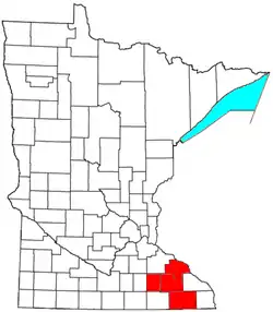 | |
|---|---|---|
| Incorporated Places | ||
| Counties | ||
‡ indicates that it is partially in the metropolitan area. † indicates a county seat. | ||
Municipalities and communities of Fillmore County, Minnesota, United States | ||
|---|---|---|
| Cities | 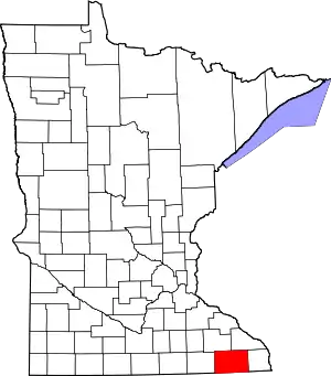 Map of Minnesota highlighting Fillmore County | |
| Townships | ||
| Unincorporated communities | ||
| Ghost towns | ||
| Footnotes | ||
| ||
| Authority control |
|
|---|