Wabasha County, Minnesota
Wabasha County is a county in the U.S. state of Minnesota. As of the 2010 United States Census, the population was 21,676.[1] Its county seat is Wabasha.[2]
Wabasha County | |
|---|---|
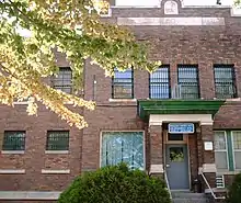
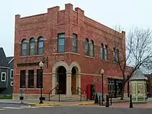 Old Wabasha City Hall in Wabasha, Minnesota. | |
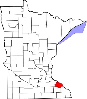 Location within the U.S. state of Minnesota | |
 Minnesota's location within the U.S. | |
| Coordinates: 44°17′N 92°14′W | |
| Country | |
| State | |
| Founded | October 27, 1849 |
| Named for | Wabasha (city) |
| Seat | Wabasha |
| Largest city | Lake City |
| Area | |
| • Total | 550 sq mi (1,400 km2) |
| • Land | 523 sq mi (1,350 km2) |
| • Water | 27 sq mi (70 km2) 4.8%% |
| Population (2010) | |
| • Total | 21,676 |
| • Estimate (2019) | 21,627 |
| • Density | 41.3/sq mi (15.9/km2) |
| Time zone | UTC−6 (Central) |
| • Summer (DST) | UTC−5 (CDT) |
| Congressional district | 2nd |
| Website | www |
Wabasha County is part of the Rochester Metropolitan Statistical Area.
History
The recently organized Minnesota Territory legislature created Wabasha County on October 27, 1849, one of nine original counties in the territory. An area on the Mississippi River's west bank, originally called Cratte's Landing, had grown into a town named Wabasha, then a city, and when the legislature created the county west of the river around this city, Wabasha was designated the county seat. The city had been named for three successive chiefs of Mississippi bands of Dakota Indians.[3]
Wabasha County's area was reduced in 1853 when sections were partitioned off to create Fillmore, Goodhue, and Rice counties. More area was partitioned off in 1854 to create Winona County, and another part in 1855 to create Olmsted County. The county boundaries have remained the same since 1855.
Geography
Wabasha County lies on Minnesota's border with Wisconsin (across the Mississippi River. The Mississippi flows southeast along the county's eastern line. The North Fork of the Whitewater River flows east through the southern part of the county, then discharges into the Whitewater in Olmsted County. The combined Whitewater then enters the southeastern part of Wabasha County, flowing northeast to its discharge point into the Mississippi. The Zumbro River flows east-northeast through the county to its discharge point into the Mississippi. East Indian Creek and Miller Creek drain the northern part of the county into the Mississippi. The county terrain consists of low rolling hills, considerably rutted by drainages, with all available area devoted to agriculture.[5] The terrain slopes to the east and south, with its highest point on its upper west border at 1,191' (363m) ASL.[6] The county has a total area of 550 square miles (1,400 km2), of which 523 square miles (1,350 km2) is land and 27 square miles (70 km2) (4.8%) is water.[7] Wabasha is one of 17 Minnesota counties with more savanna soils than either forest or prairie soils.
Major highways
Adjacent counties
- Pepin County, Wisconsin - northeast
- Buffalo County, Wisconsin - east
- Winona County - southeast
- Olmsted County - south
- Goodhue County - west, northwest
Protected areas[5]
- Carley State Park
- Kellogg-Weaver Dunes Scientific and Natural Area
- Mazeppa State Wildlife Management Area
- McCarthy Lake State Wildlife Management Area
- Zumbro Falls Woods Scientific and Natural Area
Lakes[5]
- Lake Pepin (part)
- Robinson Lake
- Zumbro Lake (part)
- These lakes are located within the Upper Mississippi River National Wildlife and Fish Refuge
- Cross Lake
- Half Moon Lake
- Maloney Lake
- McCarthy Lake
- Peterson Lake
- Robinson Lake
Demographics
| Historical population | |||
|---|---|---|---|
| Census | Pop. | %± | |
| 1850 | 243 | — | |
| 1860 | 7,228 | 2,874.5% | |
| 1870 | 15,850 | 119.3% | |
| 1880 | 18,206 | 14.9% | |
| 1890 | 16,972 | −6.8% | |
| 1900 | 18,924 | 11.5% | |
| 1910 | 18,554 | −2.0% | |
| 1920 | 17,919 | −3.4% | |
| 1930 | 19,613 | 9.5% | |
| 1940 | 17,653 | −10.0% | |
| 1950 | 16,878 | −4.4% | |
| 1960 | 17,007 | 0.8% | |
| 1970 | 17,224 | 1.3% | |
| 1980 | 19,335 | 12.3% | |
| 1990 | 19,744 | 2.1% | |
| 2000 | 21,610 | 9.5% | |
| 2010 | 21,676 | 0.3% | |
| 2019 (est.) | 21,627 | [8] | −0.2% |
| US Decennial Census[9] 1790-1960[10] 1900-1990[11] 1990-2000[12] 2010-2019[1] | |||
2000 census
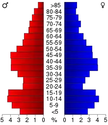
As of the 2000 United States Census, there were 21,610 people, 8,277 households, and 5,876 families in the county. The population density was 41.3/sqmi (16.0/km2). There were 9,066 housing units at an average density of 17.3/sqmi (6.69/km2). The racial makeup of the county was 97.97% White, 0.25% Black or African American, 0.27% Native American, 0.43% Asian, 0.62% from other races, and 0.45% from two or more races. 1.68% of the population were Hispanic or Latino of any race. 53.3% were of German, 11.1% Norwegian, 7.3% Irish and 5.0% American ancestry.
There were 8,277 households, out of which 33.80% had children under the age of 18 living with them, 60.80% were married couples living together, 6.50% had a female householder with no husband present, and 29.00% were non-families. 24.30% of all households were made up of individuals, and 10.80% had someone living alone who was 65 years of age or older. The average household size was 2.57 and the average family size was 3.07.
The county population contained 27.10% under the age of 18, 7.20% from 18 to 24, 27.00% from 25 to 44, 23.80% from 45 to 64, and 15.00% who were 65 years of age or older. The median age was 38 years. For every 100 females, there were 100.00 males. For every 100 females age 18 and over, there were 97.90 males.
The median income for a household in the county was $42,117, and the median income for a family was $50,480. Males had a median income of $33,053 versus $24,316 for females. The per capita income for the county was $19,664. About 4.10% of families and 6.00% of the population were below the poverty line, including 6.00% of those under age 18 and 9.30% of those age 65 or over.
Communities
Cities
- Bellechester (partly in Goodhue County)
- Elgin
- Hammond
- Kellogg
- Lake City (partly in Goodhue County)
- Mazeppa
- Millville
- Minneiska (partly in Winona County)
- Plainview
- Wabasha (county seat)
- Zumbro Falls
Unincorporated communities
Politics
Wabasha County voters have traditionally voted Republican. In only two national elections since 1964 has the county selected the Democratic Party candidate (as of 2016).
| Year | Republican | Democratic | Third parties |
|---|---|---|---|
| 2016 | 59.1% 6,989 | 32.7% 3,866 | 8.3% 977 |
| 2012 | 51.4% 6,049 | 46.0% 5,415 | 2.5% 299 |
| 2008 | 49.9% 5,935 | 47.5% 5,646 | 2.6% 312 |
| 2004 | 51.7% 6,120 | 46.9% 5,548 | 1.4% 167 |
| 2000 | 49.8% 5,245 | 42.9% 4,522 | 7.3% 764 |
| 1996 | 36.1% 3,452 | 47.3% 4,523 | 16.7% 1,598 |
| 1992 | 33.3% 3,397 | 36.6% 3,736 | 30.2% 3,084 |
| 1988 | 50.8% 4,681 | 48.2% 4,442 | 1.0% 92 |
| 1984 | 57.3% 5,299 | 41.9% 3,872 | 0.8% 76 |
| 1980 | 52.8% 4,986 | 39.3% 3,712 | 8.0% 755 |
| 1976 | 49.6% 4,484 | 47.4% 4,286 | 3.1% 279 |
| 1972 | 61.3% 5,158 | 35.9% 3,017 | 2.8% 238 |
| 1968 | 51.8% 4,081 | 43.8% 3,452 | 4.5% 353 |
| 1964 | 41.8% 3,133 | 58.2% 4,367 | 0.1% 4 |
| 1960 | 55.7% 4,566 | 44.3% 3,628 | 0.0% 3 |
| 1956 | 66.9% 4,728 | 32.6% 2,301 | 0.6% 39 |
| 1952 | 69.6% 5,461 | 30.0% 2,356 | 0.3% 26 |
| 1948 | 46.4% 3,297 | 52.5% 3,730 | 1.1% 75 |
| 1944 | 62.6% 4,213 | 36.9% 2,482 | 0.5% 33 |
| 1940 | 68.0% 5,656 | 31.9% 2,655 | 0.2% 13 |
| 1936 | 34.6% 2,663 | 53.6% 4,122 | 11.9% 912 |
| 1932 | 33.2% 2,319 | 65.1% 4,540 | 1.7% 119 |
| 1928 | 55.8% 3,944 | 43.7% 3,087 | 0.5% 32 |
| 1924 | 44.9% 2,834 | 10.2% 644 | 44.9% 2,829 |
| 1920 | 77.1% 4,907 | 20.0% 1,275 | 2.9% 182 |
| 1916 | 53.1% 1,787 | 43.1% 1,449 | 3.8% 129 |
| 1912 | 23.3% 797 | 41.6% 1,422 | 35.1% 1,198 |
| 1908 | 58.4% 2,150 | 38.4% 1,416 | 3.2% 118 |
| 1904 | 66.1% 2,315 | 30.9% 1,083 | 2.9% 102 |
| 1900 | 57.7% 2,114 | 38.4% 1,406 | 4.0% 145 |
| 1896 | 58.9% 2,530 | 37.9% 1,630 | 3.2% 138 |
| 1892 | 43.2% 1,580 | 48.5% 1,774 | 8.4% 307 |
See also
References
- "State & County QuickFacts". United States Census Bureau. Archived from the original on September 19, 2013. Retrieved September 1, 2013.
- "Find a County". National Association of Counties. Retrieved June 7, 2011.
- Upham, Warren (1920). Minnesota Geographic Names: Their Origin and Historic Significance. Minnesota Historical Society. p. 555.
- Nelson, Steven (2011). Savanna Soils of Minnesota. Minnesota: Self. pp. 43-48. ISBN 978-0-615-50320-2
- Wabasha County MN Google Maps (accessed 20 April 2019)
- "Find an Altitude/Wabasha County MN" Google Maps (accessed 20 April 2019)
- "2010 Census Gazetteer Files". US Census Bureau. August 22, 2012. Archived from the original on October 6, 2014. Retrieved October 25, 2014.
- "Population and Housing Unit Estimates". Retrieved March 26, 2020.
- "US Decennial Census". US Census Bureau. Retrieved October 25, 2014.
- "Historical Census Browser". University of Virginia Library. Retrieved October 25, 2014.
- "Population of Counties by Decennial Census: 1900 to 1990". US Census Bureau. Retrieved October 25, 2014.
- "Census 2000 PHC-T-4. Ranking Tables for Counties: 1990 and 2000" (PDF). US Census Bureau. Retrieved October 25, 2014.
- Leip, David. "Atlas of US Presidential Elections". uselectionatlas.org. Retrieved April 9, 2018.
External links
- Wabasha-Kellogg (Minnesota) Convention and Visitors Bureau
- Wabasha County government's website
- Wabasha County Health and Demographic Data
Places adjacent to Wabasha County, Minnesota | ||||||||||
|---|---|---|---|---|---|---|---|---|---|---|
| ||||||||||
Municipalities and communities of Wabasha County, Minnesota, United States | ||
|---|---|---|
| Cities | Map of Minnesota highlighting Wabasha County | |
| Townships | ||
| Unincorporated communities | ||
| Footnotes | ‡This populated place also has portions in an adjacent county or counties | |
| ||

| Authority control |
|---|