Oronoco, Minnesota
Oronoco (/ɒrəˈnoʊkoʊ/ orr-ə-NOH-koh) is a city in Olmsted County, Minnesota, United States, along the Middle Fork of the Zumbro River. The population was 1,300 at the 2010 census.[7]
Oronoco | |
|---|---|
 Oronoco Town Hall | |
| Motto(s): "Home of Downtown Oronoco Gold Rush"[1] | |
 Location of Oronoco, Minnesota | |
| Coordinates: 44°9′41″N 92°32′29″W | |
| Country | United States |
| State | Minnesota |
| County | Olmsted |
| Area | |
| • Total | 3.04 sq mi (7.89 km2) |
| • Land | 2.91 sq mi (7.55 km2) |
| • Water | 0.13 sq mi (0.34 km2) |
| Elevation | 974 ft (297 m) |
| Population | |
| • Total | 1,300 |
| • Estimate (2019)[4] | 1,525 |
| • Density | 523.34/sq mi (202.07/km2) |
| Time zone | UTC-6 (Central (CST)) |
| • Summer (DST) | UTC-5 (CDT) |
| ZIP code | 55960 |
| Area code(s) | 507 |
| FIPS code | 27-48598[5] |
| GNIS feature ID | 0649000[6] |
| Website | http://www.oronoco.com/ |
History
The city was named by early settler Dr. Hector Galloway after the similarly spelled Orinoco, a large river in South America.[8][9] A village was founded in 1854 and platted in 1855. The village incorporated as a city on March 6, 1968. Oronoco Township, which is adjacent on three sides, was organized in 1858.[10] It is a bedroom community for nearby Rochester.
Geography
According to the United States Census Bureau, the city has a total area of 2.81 square miles (7.28 km2), of which 2.49 square miles (6.45 km2) is land and 0.32 square miles (0.83 km2) is water.[11]
Demographics
| Historical population | |||
|---|---|---|---|
| Census | Pop. | %± | |
| 1880 | 241 | — | |
| 1970 | 564 | — | |
| 1980 | 574 | 1.8% | |
| 1990 | 727 | 26.7% | |
| 2000 | 883 | 21.5% | |
| 2010 | 1,300 | 47.2% | |
| 2019 (est.) | 1,525 | [4] | 17.3% |
| U.S. Decennial Census[12] | |||
2010 census
As of the census[3] of 2010, there were 1,300 people, 451 households, and 357 families living in the city. The population density was 522.1 inhabitants per square mile (201.6/km2). There were 477 housing units at an average density of 191.6 per square mile (74.0/km2). The racial makeup of the city was 95.2% White, 0.2% African American, 0.2% Native American, 3.0% Asian, 0.2% Pacific Islander, 0.5% from other races, and 0.8% from two or more races. Hispanic or Latino of any race were 0.5% of the population.
There were 451 households, of which 45.5% had children under the age of 18 living with them, 69.6% were married couples living together, 5.5% had a female householder with no husband present, 4.0% had a male householder with no wife present, and 20.8% were non-families. 16.9% of all households were made up of individuals, and 5.1% had someone living alone who was 65 years of age or older. The average household size was 2.87 and the average family size was 3.25.
The median age in the city was 36 years. 31.7% of residents were under the age of 18; 4.9% were between the ages of 18 and 24; 28.3% were from 25 to 44; 27.2% were from 45 to 64; and 8.1% were 65 years of age or older. The gender makeup of the city was 50.1% male and 49.9% female.
2000 census
As of the census of 2000, there were 883 people, 335 households, and 253 families living in the city. The population density was 482.8 people per square mile (186.3/km2). There were 343 housing units at an average density of 187.6 per square mile (72.4/km2). The racial makeup of the city was 97.40% White, 0.11% Native American, 1.13% Asian, 0.11% Pacific Islander, 0.11% from other races, and 1.13% from two or more races. Hispanic or Latino of any race were 1.81% of the population.
There were 335 households, out of which 33.7% had children under the age of 18 living with them, 65.7% were married couples living together, 6.0% had a female householder with no husband present, and 24.2% were non-families. 18.5% of all households were made up of individuals, and 6.3% had someone living alone who was 65 years of age or older. The average household size was 2.64 and the average family size was 3.00.
In the city, the population was spread out, with 25.9% under the age of 18, 6.3% from 18 to 24, 33.5% from 25 to 44, 25.8% from 45 to 64, and 8.4% who were 65 years of age or older. The median age was 38 years. For every 100 females, there were 105.3 males. For every 100 females age 18 and over, there were 105.7 males.
The median income for a household in the city was $67,656, and the median income for a family was $72,396. Males had a median income of $47,153 versus $35,694 for females. The per capita income for the city was $27,965. About 0.8% of families and 2.1% of the population were below the poverty line, including 4.3% of those under age 18 and none of those age 65 or over.
Infrastructure
Transportation
U.S. Highway 52 serves as a main route in the community.
References
- "City of Oronco Minnesota". City of Oronco Minnesota. Retrieved October 9, 2012.
- "2019 U.S. Gazetteer Files". United States Census Bureau. Retrieved July 26, 2020.
- "U.S. Census website". United States Census Bureau. Retrieved 2012-11-13.
- "Population and Housing Unit Estimates". United States Census Bureau. May 24, 2020. Retrieved May 27, 2020.
- "U.S. Census website". United States Census Bureau. Retrieved 2008-01-31.
- "US Board on Geographic Names". United States Geological Survey. 2007-10-25. Retrieved 2008-01-31.
- "2010 Census Redistricting Data (Public Law 94-171) Summary File". American FactFinder. United States Census Bureau. Retrieved 27 April 2011.
- "Profile for Oronoco, Minnesota, MN". ePodunk. Retrieved October 9, 2012.
- Chicago and North Western Railway Company (1908). A History of the Origin of the Place Names Connected with the Chicago & North Western and Chicago, St. Paul, Minneapolis & Omaha Railways. p. 111.
- Upham, Warren (1920). Minnesota Geographic Names: Their Origin and Historic Significance. Minnesota Historical Society. p. 387.
- "US Gazetteer files 2010". United States Census Bureau. Archived from the original on 2012-01-25. Retrieved 2012-11-13.
- "U.S. Decennial Census". Census.gov. Retrieved June 5, 2013.
External links
- Oronoco, Minnesota Virtual Community Center
- City of Oronco Minnesota Website
- City-Data.com
- ePodunk: Profile for Oronoco, Minnesota
Municipalities and communities of Olmsted County, Minnesota, United States | ||
|---|---|---|
| Cities | 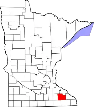 Map of Minnesota highlighting Olmsted County | |
| Townships | ||
| Unincorporated communities | ||
| Footnotes | ‡This populated place also has portions in an adjacent county or counties | |
| ||
| Core city | 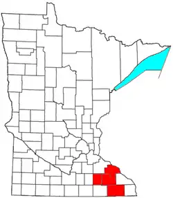 | |
|---|---|---|
| Incorporated Places | ||
| Counties | ||
‡ indicates that it is partially in the metropolitan area. † indicates a county seat. | ||
