Carmen, Bohol
Carmen, officially the Municipality of Carmen (Cebuano: Lungsod sa Carmen; Tagalog: Bayan ng Carmen), is a 2nd class municipality in the province of Bohol, Philippines. According to the 2015 census, it has a population of 46,306 people. [3]
Carmen | |
|---|---|
| Municipality of Carmen | |
 Downtown area | |
| Nickname(s): Home of the Great Chocolate Hills | |
 Map of Bohol with Carmen highlighted | |
OpenStreetMap 
| |
.svg.png.webp) Carmen Location within the Philippines | |
| Coordinates: 9°49′N 124°12′E | |
| Country | |
| Region | Central Visayas (Region VII) |
| Province | Bohol |
| District | 3rd District |
| Founded | 1 March 1869 |
| Barangays | 29 (see Barangays) |
| Government | |
| • Type | Sangguniang Bayan |
| • Mayor | Ricardo Francisco A. Toribio |
| • Vice Mayor | Romeo C. Bigay Jr. |
| • Representative | Kristine Alexie B. Tutor |
| • Electorate | 33,270 voters (2019) |
| Area | |
| • Total | 239.45 km2 (92.45 sq mi) |
| Elevation | 258 m (846 ft) |
| Population | |
| • Total | 46,306 |
| • Density | 190/km2 (500/sq mi) |
| • Households | 10,264 |
| Economy | |
| • Income class | 2nd municipal income class |
| • Poverty incidence | 29.22% (2015)[4] |
| • Revenue | ₱170,653,601.98 (2016) |
| Time zone | UTC+8 (PST) |
| ZIP code | 6319 |
| PSGC | |
| IDD : area code | +63 (0)38 |
| Climate type | tropical monsoon climate |
| Native languages | Boholano dialect Cebuano Tagalog |
| Patron saint | Anthony de Abbot |
The town of Carmen, Bohol celebrates its fiesta on January 17, to honor the town patron Saint Anthony de Abbot.[5]
History
Carmen was originally part of the municipality of Bilar and called Imbaya, after the name of a stream in the settlement.[6] During the Spanish time, it was inhabited by not more than fifty families. In 1868, the people of Carmen petitioned for its independence since its population grew to an unprecedented number. The town of Carmen was founded on 1 March 1869 by final order of Governor General Jose de la Gandara and renamed at the same time in honor of the Lady of Carmel of Spain. In 1874, the town of Carmen had its separate parish with Father Pedro Nolasco San Juan as the first parish priest.
Due to the influence of Spanish culture and tradition, all barangays of Carmen have a patron saint as well as a Spanish name, who are celebrated in an annual barangay fiesta.
In World War II, Carmen served as the stronghold of the guerrilla resistance movement and the local civil government because of its strategic location. Even at present, the municipality still serves the same purpose of being the provincial center of dynamic activities.
In 2013 a magnitude 7.2 earthquake shook Central Visayas region, with its epicenter within Carmen municipality.
Geography
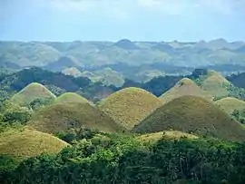
Carmen is located in the heart of Bohol Island. The Chocolate Hills, composed of 1,776 cone-shaped karst hills, are a major geographic landmark in Carmen. The origin of its name comes from the fact that the hills turns brown in the hot summer days.
Barangays
Carmen comprises 29 barangays:
| PSGC | Barangay | Population | ±% p.a. | |||
|---|---|---|---|---|---|---|
| 2015 [3] | 2010 [7] | |||||
| 071212001 | Alegria | 2.7% | 1,253 | 1,199 | 0.84% | |
| 071212002 | Bicao | 5.5% | 2,546 | 2,295 | 2.00% | |
| 071212003 | Buenavista | 5.6% | 2,605 | 2,546 | 0.44% | |
| 071212004 | Buenos Aires | 3.0% | 1,407 | 1,337 | 0.98% | |
| 071212005 | Calatrava | 4.3% | 1,974 | 1,801 | 1.76% | |
| 071212006 | El Progreso | 1.9% | 890 | 820 | 1.57% | |
| 071212007 | El Salvador | 1.2% | 566 | 543 | 0.79% | |
| 071212008 | Guadalupe | 4.5% | 2,080 | 1,991 | 0.84% | |
| 071212009 | Katipunan | 6.5% | 3,027 | 2,712 | 2.11% | |
| 071212010 | La Libertad | 1.7% | 804 | 840 | −0.83% | |
| 071212011 | La Paz | 3.2% | 1,480 | 1,430 | 0.66% | |
| 071212012 | La Salvacion | 2.3% | 1,053 | 1,061 | −0.14% | |
| 071212013 | La Victoria | 2.6% | 1,202 | 1,100 | 1.70% | |
| 071212014 | Matin‑ao | 1.9% | 882 | 800 | 1.88% | |
| 071212015 | Montehermoso | 1.9% | 874 | 952 | −1.61% | |
| 071212016 | Montesuerte | 5.8% | 2,670 | 2,467 | 1.52% | |
| 071212017 | Montesunting | 2.0% | 915 | 870 | 0.96% | |
| 071212018 | Montevideo | 2.8% | 1,295 | 1,274 | 0.31% | |
| 071212019 | Nueva Fuerza | 5.3% | 2,433 | 2,281 | 1.24% | |
| 071212020 | Nueva Vida Este | 1.9% | 884 | 918 | −0.72% | |
| 071212022 | Nueva Vida Norte | 2.1% | 967 | 981 | −0.27% | |
| 071212021 | Nueva Vida Sur | 2.0% | 909 | 915 | −0.13% | |
| 071212023 | Poblacion Norte | 7.0% | 3,224 | 2,937 | 1.79% | |
| 071212024 | Poblacion Sur | 7.1% | 3,279 | 2,961 | 1.96% | |
| 071212025 | Tambo‑an | 2.8% | 1,301 | 1,175 | 1.96% | |
| 071212026 | Vallehermoso | 0.6% | 262 | 241 | 1.60% | |
| 071212027 | Villaflor | 2.0% | 904 | 863 | 0.89% | |
| 071212028 | Villafuerte | 2.7% | 1,231 | 1,012 | 3.80% | |
| 071212029 | Villacayo | 4.1% | 1,890 | 1,789 | 1.05% | |
| Total | 46,306 | 43,579 | 1.16% | |||
Climate
| Climate data for Carmen, Bohol | |||||||||||||
|---|---|---|---|---|---|---|---|---|---|---|---|---|---|
| Month | Jan | Feb | Mar | Apr | May | Jun | Jul | Aug | Sep | Oct | Nov | Dec | Year |
| Average high °C (°F) | 27 (81) |
27 (81) |
28 (82) |
30 (86) |
29 (84) |
28 (82) |
28 (82) |
28 (82) |
28 (82) |
27 (81) |
27 (81) |
27 (81) |
28 (82) |
| Average low °C (°F) | 21 (70) |
21 (70) |
21 (70) |
22 (72) |
23 (73) |
23 (73) |
23 (73) |
23 (73) |
23 (73) |
22 (72) |
22 (72) |
21 (70) |
22 (72) |
| Average precipitation mm (inches) | 102 (4.0) |
85 (3.3) |
91 (3.6) |
75 (3.0) |
110 (4.3) |
141 (5.6) |
121 (4.8) |
107 (4.2) |
111 (4.4) |
144 (5.7) |
169 (6.7) |
139 (5.5) |
1,395 (55.1) |
| Average rainy days | 18.6 | 14.8 | 16.5 | 16.7 | 23.9 | 26.4 | 25.6 | 24.1 | 24.4 | 26.3 | 23.7 | 20.5 | 261.5 |
| Source: Meteoblue (Use with caution: this is modeled/calculated data, not measured locally.) [8] | |||||||||||||
Demographics

|
| ||||||||||||||||||||||||||||||||||||||||||||||||
| Source: Philippine Statistics Authority [3] [7] [9][10] | |||||||||||||||||||||||||||||||||||||||||||||||||
References
- Municipality of Carmen | (DILG)
- "Province: Bohol". PSGC Interactive. Quezon City, Philippines: Philippine Statistics Authority. Retrieved 12 November 2016.
- Census of Population (2015). "Region VII (Central Visayas)". Total Population by Province, City, Municipality and Barangay. PSA. Retrieved 20 June 2016.
- "PSA releases the 2015 Municipal and City Level Poverty Estimates". Quezon City, Philippines. Retrieved 12 October 2019.
- "Bohol Festivals Timetable". bohol-philippines.com. Retrieved 2019-03-13.
- "MUNICIPALITY OF CARMEN". bohol.gov.ph. Retrieved February 3, 2019.
- Census of Population and Housing (2010). "Region VII (Central Visayas)". Total Population by Province, City, Municipality and Barangay. NSO. Retrieved 29 June 2016.
- "Carmen: Average Temperatures and Rainfall". Meteoblue. Retrieved 9 May 2020.
- Censuses of Population (1903–2007). "Region VII (Central Visayas)". Table 1. Population Enumerated in Various Censuses by Province/Highly Urbanized City: 1903 to 2007. NSO.
- "Province of Bohol". Municipality Population Data. Local Water Utilities Administration Research Division. Retrieved 17 December 2016.
External links
| Wikimedia Commons has media related to Carmen, Bohol. |
- Carmen Profile at PhilAtlas.com
- Philippine Standard Geographic Code
- Provincial Government of Bohol
- Latest Carmen Bohol News
- Carmen
