Lila, Bohol
Lila, officially the Municipality of Lila (Cebuano: Lungsod sa Lila; Tagalog: Bayan ng Lila), is a 5th class municipality in the province of Bohol, Philippines. According to the 2015 census, it has a population of 12,257 people. [3]
Lila | |
|---|---|
| Municipality of Lila | |
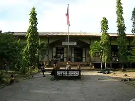
 Municipal building of Lila | |
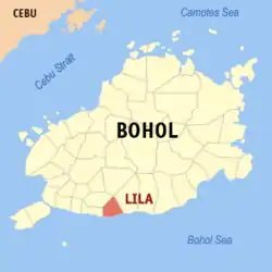 Map of Bohol with Lila highlighted | |
OpenStreetMap 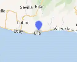
| |
.svg.png.webp) Lila Location within the Philippines | |
| Coordinates: 9°36′N 124°06′E | |
| Country | |
| Region | Central Visayas (Region VII) |
| Province | Bohol |
| District | 3rd District |
| Founded | 1 January 1915 |
| Barangays | 18 (see Barangays) |
| Government | |
| • Type | Sangguniang Bayan |
| • Mayor | Arturo A. Piollo II |
| • Vice Mayor | Regina C. Salazar |
| • Representative | Kristine Alexie B. Tutor |
| • Electorate | 7,571 voters (2019) |
| Area | |
| • Total | 40.50 km2 (15.64 sq mi) |
| Elevation | 99 m (325 ft) |
| Population | |
| • Total | 12,257 |
| • Density | 300/km2 (780/sq mi) |
| • Households | 2,082 |
| Economy | |
| • Income class | 5th municipal income class |
| • Poverty incidence | 26.34% (2015)[4] |
| • Revenue | ₱49,539,114.30 (2016) |
| Time zone | UTC+8 (PST) |
| ZIP code | 6304 |
| PSGC | |
| IDD : area code | +63 (0)38 |
| Climate type | tropical monsoon climate |
| Native languages | Boholano dialect Cebuano Tagalog |
| Website | www |
Thirty kilometres (19 mi) from Tagbilaran, it is bound to the east by Dimiao, to the west by Loay and to the north by Loboc.
The town of Lila, Bohol celebrates its fiesta on October 10, to honor the town patron the Holy Rosary.[5]
History
The coastal town of Lila once belonged to the Municipality of Dimiao. It was composed of the barrios of the municipalities of Loay and Dimiao. In 1899, during the Spanish–American War, the municipal building, the church and neighboring houses were razed to the ground and burned. Thus, no records can be shown stating when Lila was annexed to the town of Dimiao. However, the Agustinian mission in Bohol has written that Lila was a separate municipality in 1879, with a population of 4,023.
Later, a town was founded and part of the municipality was annexed back to Loay and part to Dimiao. From that time up to 1914, the municipal government of Lila ceased to function.
However, in 1915 the municipality of Lila was re-established, with Celestino Oculam as Mayor. That part of Lila annexed to Dimiao and those annexed to Loay were returned and formed the new municipality of Lila.
For the church, it was initially administered alternately by a priest stationed in Loay and Dimiao due to the scarcity of priests. It was only in 1921 that the priest of Lila had a residential parish. The church and the convent built then were only made of light materials.
In 1915, during the administration of Fr. Narciso Maglasang, the present church was built. The convent was constructed under the administration of Fr. Miguel Ortega some time in the year 1941.
After World War II, the town prospered.
Barangays
Lila comprises 18 barangays, of which 10 are coastal and 8 inland:
| PSGC | Barangay | Population | ±% p.a. | |||
|---|---|---|---|---|---|---|
| 2015 [3] | 2010 [6] | |||||
| 071227001 | Banban | 7.9% | 967 | 918 | 1.00% | |
| 071227002 | Bonkokan Ilaya | 5.4% | 660 | 691 | −0.87% | |
| 071227003 | Bonkokan Ubos | 6.4% | 788 | 775 | 0.32% | |
| 071227004 | Calvario | 7.8% | 959 | 919 | 0.81% | |
| 071227005 | Candulang | 3.1% | 384 | 378 | 0.30% | |
| 071227006 | Catugasan | 3.3% | 408 | 431 | −1.04% | |
| 071227007 | Cayupo | 1.8% | 223 | 214 | 0.79% | |
| 071227008 | Cogon | 3.9% | 480 | 460 | 0.81% | |
| 071227009 | Jambawan | 4.9% | 605 | 575 | 0.97% | |
| 071227010 | La Fortuna | 5.7% | 700 | 677 | 0.64% | |
| 071227011 | Lomanoy | 4.8% | 591 | 616 | −0.79% | |
| 071227012 | Macalingan | 4.6% | 568 | 558 | 0.34% | |
| 071227013 | Malinao East | 6.9% | 842 | 800 | 0.98% | |
| 071227014 | Malinao West | 1.9% | 230 | 243 | −1.04% | |
| 071227015 | Nagsulay | 8.7% | 1,070 | 1,031 | 0.71% | |
| 071227016 | Poblacion | 9.7% | 1,195 | 1,163 | 0.52% | |
| 071227017 | Taug | 5.2% | 642 | 635 | 0.21% | |
| 071227018 | Tiguis | 7.7% | 945 | 901 | 0.91% | |
| Total | 12,257 | 11,985 | 0.43% | |||
Climate
| Climate data for Lila, Bohol | |||||||||||||
|---|---|---|---|---|---|---|---|---|---|---|---|---|---|
| Month | Jan | Feb | Mar | Apr | May | Jun | Jul | Aug | Sep | Oct | Nov | Dec | Year |
| Average high °C (°F) | 28 (82) |
29 (84) |
30 (86) |
31 (88) |
31 (88) |
30 (86) |
30 (86) |
30 (86) |
30 (86) |
29 (84) |
29 (84) |
29 (84) |
30 (85) |
| Average low °C (°F) | 23 (73) |
22 (72) |
23 (73) |
23 (73) |
24 (75) |
25 (77) |
24 (75) |
24 (75) |
24 (75) |
24 (75) |
23 (73) |
23 (73) |
24 (74) |
| Average precipitation mm (inches) | 102 (4.0) |
85 (3.3) |
91 (3.6) |
75 (3.0) |
110 (4.3) |
141 (5.6) |
121 (4.8) |
107 (4.2) |
111 (4.4) |
144 (5.7) |
169 (6.7) |
139 (5.5) |
1,395 (55.1) |
| Average rainy days | 18.6 | 14.8 | 16.5 | 16.7 | 23.9 | 26.4 | 25.6 | 24.1 | 24.4 | 26.3 | 23.7 | 20.5 | 261.5 |
| Source: Meteoblue [7] | |||||||||||||
Demographics
| Year | Pop. | ±% p.a. |
|---|---|---|
| 1903 | 5,243 | — |
| 1918 | 6,514 | +1.46% |
| 1939 | 7,981 | +0.97% |
| 1948 | 8,701 | +0.96% |
| 1960 | 7,693 | −1.02% |
| 1970 | 8,645 | +1.17% |
| 1975 | 8,728 | +0.19% |
| 1980 | 8,278 | −1.05% |
| 1990 | 8,556 | +0.33% |
| 1995 | 9,014 | +0.98% |
| 2000 | 10,322 | +2.95% |
| 2007 | 10,801 | +0.63% |
| 2010 | 11,985 | +3.86% |
| 2015 | 12,257 | +0.43% |
| Source: Philippine Statistics Authority [3] [6] [8][9] | ||
Gallery
 Elementary school in Poblacion, Lila
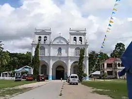 Catholic Church
.jpg.webp) Lila Church ceiling
Lila Church ceiling
References
- Municipality of Lila | (DILG)
- "Province: Bohol". PSGC Interactive. Quezon City, Philippines: Philippine Statistics Authority. Retrieved 12 November 2016.
- Census of Population (2015). "Region VII (Central Visayas)". Total Population by Province, City, Municipality and Barangay. PSA. Retrieved 20 June 2016.
- "PSA releases the 2015 Municipal and City Level Poverty Estimates". Quezon City, Philippines. Retrieved 12 October 2019.
- "Bohol Festivals Timetable". "www.bohol-philippines.com". Retrieved 2019-03-05.
- Census of Population and Housing (2010). "Region VII (Central Visayas)". Total Population by Province, City, Municipality and Barangay. NSO. Retrieved 29 June 2016.
- "Lila: Average Temperatures and Rainfall". Meteoblue. Retrieved 9 May 2020.
- Censuses of Population (1903–2007). "Region VII (Central Visayas)". Table 1. Population Enumerated in Various Censuses by Province/Highly Urbanized City: 1903 to 2007. NSO.
- "Province of Bohol". Municipality Population Data. Local Water Utilities Administration Research Division. Retrieved 17 December 2016.
| Wikimedia Commons has media related to Lila. |
External links
- Lila Profile at PhilAtlas.com
- Philippine Standard Geographic Code
- Lila
- History of Lila
- Municipality of Lila