Panglao, Bohol
Panglao, officially the Municipality of Panglao (Cebuano: Lungsod sa Panglao; Tagalog: Bayan ng Panglao), is a 4th class municipality in the province of Bohol, Philippines. According to the 2015 census, it has a population of 33,553 people. [5]
Panglao | |
|---|---|
| Municipality of Panglao | |
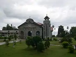 St. Augustine church and watchtower | |
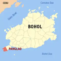 Map of Bohol with Panglao highlighted | |
OpenStreetMap 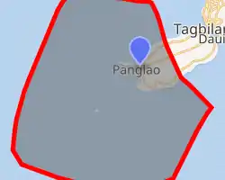
| |
.svg.png.webp) Panglao Location within the Philippines | |
| Coordinates: 9°35′N 123°45′E | |
| Country | |
| Region | Central Visayas (Region VII) |
| Province | Bohol |
| District | 1st District |
| Founded | 1803 |
| Barangays | 10 (see Barangays) |
| Government | |
| • Type | Sangguniang Bayan |
| • Mayor | Leonila 'Nila' P. Montero[2] |
| • Vice Mayor | Briccio 'Brian' D. Velasco[2] |
| • Representative | Edgardo 'Edgar' M. Chatto[3] |
| • Electorate | 24,223 voters (2019) |
| Area | |
| • Total | 47.79 km2 (18.45 sq mi) |
| Elevation | 2.0 m (6.6 ft) |
| Population | |
| • Total | 33,553 |
| • Density | 700/km2 (1,800/sq mi) |
| • Households | 7,006 |
| Economy | |
| • Income class | 4th municipal income class |
| • Poverty incidence | 19.67% (2015)[6] |
| • Revenue | ₱128,505,879.05 (2016) |
| Time zone | UTC+8 (PST) |
| ZIP code | 6340 |
| PSGC | |
| IDD : area code | +63 (0)38 |
| Climate type | tropical monsoon climate |
| Native languages | Boholano dialect Cebuano Tagalog |
| Website | www |
It is one of two municipalities that make up Panglao Island (the other being Dauis). Panglao is known for its diving locations and tourist resorts.[7]
The name Panglao may have come from its former name Panglawod, meaning "to the open sea",[8] or derived from the word panggaw, referring to a fishing implement used by locals.[9]
Panglao has educational institutions, including the San Agustin Academy (Panglao), Lourdes National High School, the Cristal e-College, and elementary schools located in every barangay (including the Panglao Central Elementary School). It is also home to Panglao Island International Airport that serves as Bohol's primary airport replacing Tagbilaran Airport. It opened in November 2018.[10]
The town of Panglao, Bohol celebrates its fiesta on August 27–28, to honor the town patron San Agustin.[11]
History
Well before the Spanish colonization, the area was already long visited by Chinese and other Asian traders, as evinced by archaeological finds of Tang, Song, and Ming dynasty porcelain and trade wares.[9]
Panglao flourished during the rule of the Dapitan kingdom, but raids by Moluccans and conquest by Ternate resulted in periods of depopulation when its population fled mostly to Panay and Mindanao, including Dapitan.[9]
During the Spanish rule, a Jesuit mission post was established, that in 1782 was formed into a parish, known as La Iglesia de San Agustin de Panglawod. In 1803, the town was officially made into a municipality.[8]
The Panglao watchtower was built in 1851. The 5-storey octagonal tower is the tallest of its kind in the Philippines but suffers from neglect.[8]
Geography
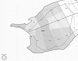
The municipality occupies the southwestern part of the eponymous Panglao Island, and its territory also includes the three smaller islands of Balicasag,[12] Gak‑ang, and Pontod (or Pungtud, also known as Virgin Island).[9]
There are no fresh water streams or lakes on the island, so for its drinking water, the municipality is dependent on wells and the Canhilbas Underground Spring.[9]
Climate
| Climate data for Panglao, Bohol | |||||||||||||||
|---|---|---|---|---|---|---|---|---|---|---|---|---|---|---|---|
| Jan | Feb | Mar | Apr | May | Jun | Jul | Aug | Sep | Oct | Nov | Dec | Year | |||
| 30.3 86.5 |
30.5 86.9 |
31.4 88.5 |
32.6 90.7 |
33.1 91.6 |
32.5 90.5 |
32.1 89.8 |
32.3 90.1 |
32.1 89.8 |
31.9 89.4 |
31.6 88.9 |
31.0 87.8 |
31.8 89.2 | |||
| 26.3 79.3 |
26.3 79.3 |
26.9 80.4 |
27.9 82.2 |
28.5 83.3 |
28.1 82.6 |
27.8 82.0 |
27.9 82.2 |
27.7 81.9 |
27.6 81.7 |
27.3 81.1 |
26.9 80.4 |
27.5 81.5 | |||
| 22.3 72.1 |
22.2 72.0 |
22.5 72.5 |
23.3 73.9 |
23.9 75.0 |
23.7 74.7 |
23.5 74.3 |
23.6 74.5 |
23.4 74.1 |
23.3 73.9 |
23.1 73.6 |
22.9 73.2 |
23.1 73.6 | |||
| 119 4.7 |
90 3.5 |
88 3.5 |
70 2.8 |
96 3.8 |
147 5.8 |
137 5.4 |
116 4.6 |
130 5.1 |
190 7.5 |
217 8.5 |
144 5.7 |
1,544 61 | |||
| Climate-data.org[13] July 2016 | Köppen-Geiger climate classification Af | Coronas type III | |||||||||||||
Barangays
Panglao comprises 10 barangays:
| ||||||||||||||||||||||||||||||||||||||||||||||||||||||||||||||||||||||||||||||||||||||||||||||||||||||||||||||||||||||||||||||||||||||||||||||

Demographics
|
| ||||||||||||||||||||||||||||||||||||||||||||||||
| Source: Philippine Statistics Authority [5] [14] [15][16] | |||||||||||||||||||||||||||||||||||||||||||||||||
Tourism
The primary tourist attraction of Panglao are its white sandy beaches, of which Alona Beach is the most famous and most developed. Alona Beach is about 1,500 metres (1,640 yd) long, lined with palm trees. resorts, and shops.[17] However it has drawn criticism for its unrestrained development that ignored municipal development policies, warning against overcrowding and Alona to lose its paradise-like image.[18] Therefore, the municipal, provincial and national governments are ploughing ahead with a plan to build a new international airport on Panglao island, with the final approach path directly over Alona beach. Currently plan is to be operational at the end of 2018. Other beaches include Bagobo, Bolod, Danao, Doljo, and Momo Beaches.
Panglao is renowned for snorkeling and dive sites such as Doljo Beach, Garden Eels, Arco Point, Kalipayan, Napaling, and Puntod. The island's southern portion is ringed with reefs that are relatively narrow and shallow (5 to 6 metres (16 to 20 ft)) with submarine cliffs plunging to depths of 33 to 56 metres (108 to 184 ft).[19] Tours can readily be arranged to further dive sites, including Balicasag and Pamilacan, Bohol islands.
Gallery
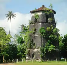 Panglao watchtower
.jpg.webp) Panglao Island Nature Resort
Panglao Island Nature Resort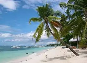 Alona Beach, Panglao, Bohol
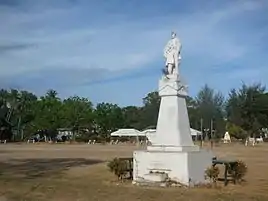 Rizal Monument at Panglao plaza
Notable people
- Rebecca Lusterio – Actress, born on Balicasag island
References
- Municipality of Panglao | (DILG)
- "Montero reassumes mayoral post; Fuertes calls move 'inciting to sedition'". 2018-09-10. Retrieved September 10, 2018.
- https://halalanresults.abs-cbn.com/local/bohol/panglao
- "Province: Bohol". PSGC Interactive. Quezon City, Philippines: Philippine Statistics Authority. Retrieved 12 November 2016.
- Census of Population (2015). "Region VII (Central Visayas)". Total Population by Province, City, Municipality and Barangay. PSA. Retrieved 20 June 2016.
- "PSA releases the 2015 Municipal and City Level Poverty Estimates". Quezon City, Philippines. Retrieved 12 October 2019.
- "Discover Panglao Island Bohol". "www.bohol-philippines.com". Retrieved 2019-04-08.
- "Bohol Panglao Island Travel Guide". A1 Online Communication and Advertising. Retrieved 6 September 2012.
- "Municipal Profile". Municipality of Panglao. Archived from the original on 2012-09-15. Retrieved 5 September 2012.
- "DOTR-CAAP inaugurates New Bohol-Panglao International Airport". caap.gov.ph. CAAP Official Website. 27 November 2018. Retrieved 7 May 2019.
- "Bohol Festivals Timetable". "www.bohol-philippines.com". Retrieved 2019-03-04.
- "Balicasag Island". Dream Native Resort. Archived from the original on 25 June 2015. Retrieved 14 July 2016.
- "Climatological Information for Panglao, Bohol". AmbiWeb GmbH. Retrieved 14 July 2016.
- Census of Population and Housing (2010). "Region VII (Central Visayas)". Total Population by Province, City, Municipality and Barangay. NSO. Retrieved 29 June 2016.
- Censuses of Population (1903–2007). "Region VII (Central Visayas)". Table 1. Population Enumerated in Various Censuses by Province/Highly Urbanized City: 1903 to 2007. NSO.
- "Province of Bohol". Municipality Population Data. Local Water Utilities Administration Research Division. Retrieved 17 December 2016.
- "Alona Beach, Panglao Island". A1 Online Communication and Advertising. Retrieved 6 September 2012.
- Philstar, Angeline Valencia (15 August 2012). "Mayor Alcala warns Panglao may become as crowded as Boracay". The Philippine Star. Retrieved 6 September 2012.
- "Panglao Island Diving". A1 Online Communication and Advertising. Retrieved 6 September 2012.
External links
| Wikivoyage has a travel guide for Panglao. |
| Wikimedia Commons has media related to Panglao, Bohol. |
- Panglao Profile at PhilAtlas.com
- Philippine Standard Geographic Code
- Municipality of Panglao
- Panglao
- Alona Beach Guide
Places adjacent to Panglao, Bohol | ||||||||||
|---|---|---|---|---|---|---|---|---|---|---|
| ||||||||||
| Authority control |
|
|---|