Cascadia, Oregon
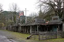
Cascadia is an unincorporated community and census-designated place (CDP) that was established in 1892 on the South Santiam River, 14 miles (23 km) east of the current city of Sweet Home, in Linn County, Oregon, United States. As of the 2010 census it had a population of 147.[2]
Cascadia, Oregon | |
|---|---|
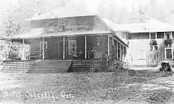 Hotel in Cascadia, circa 1925 | |
 Cascadia  Cascadia | |
| Coordinates: 44°23′51″N 122°28′50″W | |
| Country | United States |
| State | Oregon |
| County | Linn |
| Area | |
| • Total | 5.0 sq mi (13.0 km2) |
| • Land | 5.0 sq mi (13.0 km2) |
| • Water | 0.0 sq mi (0.0 km2) |
| Elevation | 840 ft (260 m) |
| Population | |
| • Total | 147 |
| • Density | 29/sq mi (11/km2) |
| Time zone | UTC-8 (Pacific (PST)) |
| • Summer (DST) | UTC-7 (PDT) |
| ZIP codes | 97329, 97345 |
| FIPS code | 41-11700 |
| GNIS feature ID | 1139425 |
Originally a stage stop on the Santiam Wagon Road, then a summer resort also known as Cascadia Mineral Springs,[3] Cascadia had a post office established in 1898. It maintains a ZIP code of 97329. The resort had a hotel established by George Geisendorfer, who was also the first postmaster. People were attracted to Cascadia because of its mineral spring water.[4] The property was sold to the state in 1940 and now is the site of the 300-acre (1.2 km2) Cascadia State Park.
Climate
This region experiences warm (but not hot) and dry summers, with no average monthly temperatures above 71.6 °F (22.0 °C) According to the Köppen Climate Classification system, Cascadia has a warm-summer Mediterranean climate, abbreviated "Csb" on climate maps.[5]
Transportation
U.S. Route 20 passes through the community, leading west 14 miles (23 km) to Sweet Home and 43 miles (69 km) to Albany, and east over Tombstone Pass 81 miles (130 km) to Bend.
References
- "2019 U.S. Gazetteer Files: Places: Oregon". United States Census Bureau. Retrieved August 24, 2020.
- "Total Population: 2010 Census DEC Summary File 1 (P1), Cascadia CDP, Oregon". data.census.gov. U.S. Census Bureau. Retrieved August 24, 2020.
- http://www.linncountyroots.com/Towns2/TownsAbb-Crab.htm#Cascadia
- http://photos.salemhistory.net/cdm4/item_viewer.php?CISOROOT=/max&CISOPTR=1582&REC=19
- Climate Summary for Cascadia, Oregon
External links
- Historic Images of Cascadia from Salem Public Library
- Cascadia State Park Brochure with History
Municipalities and communities of Linn County, Oregon, United States | ||
|---|---|---|
| Cities | 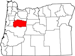 Linn County map | |
| CDPs | ||
| Other unincorporated communities | ||
| Ghost towns | ||
| Indian reservation | ||
| Footnotes | ‡This populated place also has portions in an adjacent county or counties | |
| ||