Shedd, Oregon
Shedd is an unincorporated community and census-designated place (CDP) in Linn County, Oregon, United States, on Oregon Route 99E. As of the 2010 census it had a population of 204.[2]
Shedd, Oregon | |
|---|---|
 Shedd  Shedd | |
| Coordinates: 44°27′42″N 123°6′33″W | |
| Country | United States |
| State | Oregon |
| County | Linn |
| Area | |
| • Total | 1.51 sq mi (3.91 km2) |
| • Land | 1.51 sq mi (3.91 km2) |
| • Water | 0.0 sq mi (0.0 km2) |
| Elevation | 266 ft (81 m) |
| Population | |
| • Total | 204 |
| • Density | 140/sq mi (52/km2) |
| Time zone | UTC-8 (Pacific (PST)) |
| • Summer (DST) | UTC-7 (PDT) |
| ZIP code | 97377 |
| Area code(s) | 541 / 458 |
| FIPS code | 41-66900 |
| GNIS feature ID | 1637930 |
History
In 1858, a community and gristmill was established about a mile and a half east of the present town of Shedd and called "Boston", probably because one of the founders came from Boston, Massachusetts.[3][4] Boston was platted in 1861 with a New England-style town square.[4][5] The town became a stagecoach stop, and "Boston Mills" post office was established in 1869. Efforts to get the Oregon and California Railroad, which was being built south from Albany, to come through Boston Mills were unsuccessful. The railroad was instead built through the nearby land donated by Civil War veteran Captain Frank Shedd, and "Shedd's Station" was created in 1871. The post office was moved soon after.[3][4] Many of Boston's buildings, though not the mill itself nor the Farwell DLC homestead, were moved west to the new Shedd's Station to be near the railroad.[5] In 1899, the railroad changed the name of the station to "Shedd", but the name of the post office did not change until 1915.[3]
East of Shedd at the former site of Boston Mills, on the Calapooia River, is the National Register of Historic Places-listed Boston Flour Mill (aka Thompson's Flouring Mill), Oregon's oldest continuously operating water-powered mill, part of Thompson's Mills State Heritage Site.[6] It is one of the four remaining gristmills in the state, and one of only two mills still in operation.[7]
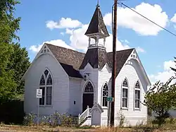 United Presbyterian Church in Shedd, listed on the National Register of Historic Places |
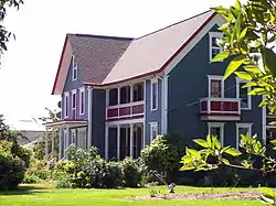 Porter-Brasfield House, listed on the National Register of Historic Places |
Geography
Shedd is in western Linn County in the Willamette River valley, with Shedd Slough, a tributary of the Calapooia River, flowing northwards on the east side of town. Oregon Route 99E passes through the center of town, leading north 12 miles (19 km) to Albany and south 5 miles (8 km) to Halsey.
According to the U.S. Census Bureau, the Shedd CDP has an area of 1.5 square miles (3.9 km2), all of it recorded as land.[1]
References
- "2019 U.S. Gazetteer Files: Places: Oregon". United States Census Bureau. Retrieved August 25, 2020.
- "Total Population: 2010 Census DEC Summary File 1 (P1), Shedd CDP, Oregon". data.census.gov. U.S. Census Bureau. Retrieved August 25, 2020.
- McArthur, Lewis A.; Lewis L. McArthur (2003) [1928]. Oregon Geographic Names (Seventh ed.). Portland, Oregon: Oregon Historical Society Press. pp. 101, 865. ISBN 0-87595-277-1.
- "Thompson's Mills State Heritage Site Master Plan" (PDF). Oregon Parks and Recreation Department. Retrieved 2008-01-01.
- Sullivan, William (December 25, 2007). "A look at Oregon's newest state park". The Register-Guard. Retrieved 2008-01-01.
- "Newest state park to open". Oregon Parks and Recreation Department. December 4, 2007. Retrieved 2008-01-01.
- "Boston Mill Society". Retrieved 2008-01-01.
External links
- History of Boston Mills from Linn County Historical Society
- Historic images of Shedd from Salem Public Library
- Historic images of Thompson's Mill from Salem Public Library
- Historic images of Shedd and the Shedd family from Webshots
Municipalities and communities of Linn County, Oregon, United States | ||
|---|---|---|
| Cities | 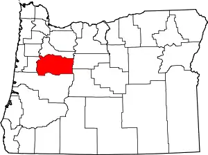 Linn County map | |
| CDPs | ||
| Other unincorporated communities | ||
| Ghost towns | ||
| Indian reservation | ||
| Footnotes | ‡This populated place also has portions in an adjacent county or counties | |
| ||