Linn County, Oregon
Linn County is one of the 36 counties in the U.S. state of Oregon. As of the 2010 census, the population was 116,672.[1] The county seat is Albany.[2] The county is named in honor of Lewis F. Linn,[3] a U.S. Senator from Missouri who advocated the American settlement of the Oregon Country. Linn County comprises the Albany, OR Metropolitan Statistical Area, which is included in the Portland-Vancouver-Salem, OR-WA Combined Statistical Area. It is located in the Willamette Valley. In 2010, the center of population of Oregon was located in Linn County, near the city of Lyons.[4]
Linn County | |
|---|---|
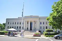 Linn County Courthouse in Albany | |
 Flag  Seal | |
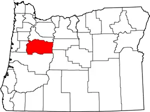 Location within the U.S. state of Oregon | |
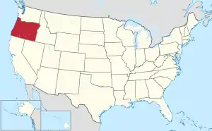 Oregon's location within the U.S. | |
| Coordinates: 44°38′N 123°05′W | |
| Country | |
| State | |
| Founded | December 28, 1847 |
| Seat | Albany |
| Largest city | Albany |
| Area | |
| • Total | 2,309 sq mi (5,980 km2) |
| • Land | 2,290 sq mi (5,900 km2) |
| • Water | 19 sq mi (50 km2) 0.8%% |
| Population (2010) | |
| • Total | 116,672 |
| • Estimate (2019) | 129,749 |
| • Density | 51/sq mi (20/km2) |
| Time zone | UTC−8 (Pacific) |
| • Summer (DST) | UTC−7 (PDT) |
| Congressional district | 4th |
| Website | www |
History
On December 28, 1847 the Provisional Legislature created Linn County from the southern portion of Champoeg (later Marion) County. The boundaries were altered in 1851 and 1854 with the creation of Lane and Wasco Counties. The county seat was originally located in Calapooia (later known as Brownsville), but in 1851 the Territorial Legislature passed an act establishing Albany as the county seat. A special election in 1856 reaffirmed Albany as the county seat.
Geography
According to the U.S. Census Bureau, the county has a total area of 2,309 square miles (5,980 km2), of which 2,290 square miles (5,900 km2) is land and 19 square miles (49 km2) (0.8%) is water.[5]
Adjacent counties
- Polk County (northwest)
- Marion County (north)
- Jefferson County (east)
- Deschutes County (southeast)
- Lane County (south)
- Benton County (west)
National protected area
- Willamette National Forest (part)
Demographics
| Historical population | |||
|---|---|---|---|
| Census | Pop. | %± | |
| 1850 | 994 | — | |
| 1860 | 6,772 | 581.3% | |
| 1870 | 8,717 | 28.7% | |
| 1880 | 12,676 | 45.4% | |
| 1890 | 16,265 | 28.3% | |
| 1900 | 18,603 | 14.4% | |
| 1910 | 22,662 | 21.8% | |
| 1920 | 24,550 | 8.3% | |
| 1930 | 24,700 | 0.6% | |
| 1940 | 30,485 | 23.4% | |
| 1950 | 54,317 | 78.2% | |
| 1960 | 58,867 | 8.4% | |
| 1970 | 71,914 | 22.2% | |
| 1980 | 89,465 | 24.4% | |
| 1990 | 91,227 | 2.0% | |
| 2000 | 103,069 | 13.0% | |
| 2010 | 116,672 | 13.2% | |
| 2019 (est.) | 129,749 | [6] | 11.2% |
| U.S. Decennial Census[7] 1790-1960[8] 1900-1990[9] 1990-2000[10] 2010-2019[1] | |||
2000 census
As of the census[11] of 2000, there were 103,069 people, 39,541 households, and 28,232 families living in the county. The population density was 45 people per square mile (17/km2). There were 42,521 housing units at an average density of 19 per square mile (7/km2). The racial makeup of the county was 93.20% White, 0.32% Black or African American, 1.27% Native American, 0.78% Asian, 0.15% Pacific Islander, 1.80% from other races, and 2.49% from two or more races. 4.38% of the population were Hispanic or Latino of any race. 22.2% were of German, 13.0% American, 11.2% English and 8.6% Irish ancestry.
There were 39,541 households, out of which 32.00% had children under the age of 18 living with them, 56.90% were married couples living together, 10.00% had a female householder with no husband present, and 28.60% were non-families. 23.00% of all households were made up of individuals, and 10.10% had someone living alone who was 65 years of age or older. The average household size was 2.58 and the average family size was 3.01.
In the county, the population was spread out, with 26.00% under the age of 18, 8.40% from 18 to 24, 27.00% from 25 to 44, 24.10% from 45 to 64, and 14.50% who were 65 years of age or older. The median age was 37 years. For every 100 females there were 97.50 males. For every 100 females age 18 and over, there were 95.00 males.
The median income for a household in the county was $37,518, and the median income for a family was $44,188. Males had a median income of $35,586 versus $24,073 for females. The per capita income for the county was $17,633. About 8.90% of families and 11.40% of the population were below the poverty line, including 14.80% of those under age 18 and 7.10% of those age 65 or over.
2010 census
As of the 2010 United States Census, there were 116,672 people, 45,204 households, and 30,976 families living in the county.[12] The population density was 50.9 inhabitants per square mile (19.7/km2). There were 48,821 housing units at an average density of 21.3 per square mile (8.2/km2).[13] The racial makeup of the county was 90.6% white, 1.3% American Indian, 1.0% Asian, 0.5% black or African American, 0.1% Pacific islander, 3.3% from other races, and 3.3% from two or more races. Those of Hispanic or Latino origin made up 7.8% of the population.[12] In terms of ancestry, 22.9% were German, 14.1% were English, 12.7% were Irish, and 7.1% were American.[14]
Of the 45,204 households, 32.1% had children under the age of 18 living with them, 52.1% were married couples living together, 11.2% had a female householder with no husband present, 31.5% were non-families, and 24.4% of all households were made up of individuals. The average household size was 2.55 and the average family size was 3.01. The median age was 39.2 years.[12]
The median income for a household in the county was $45,832 and the median income for a family was $55,320. Males had a median income of $44,450 versus $32,055 for females. The per capita income for the county was $22,165. About 11.0% of families and 15.6% of the population were below the poverty line, including 23.0% of those under age 18 and 7.8% of those age 65 or over.[15]
Government and politics
Linn County is the most conservative county in the Willamette Valley: the last Democrat to win a majority in the county was Jimmy Carter in 1976.[16] In 2016 Donald Trump won 57.03 percent of the vote to Hillary Clinton's 30.65 percent; in 2012 Mitt Romney won 56.28 percent to president-elect Obama's 39.63 percent, and Obama's 2008 result of 42.64 percent[17] is the best by a Democrat since Michael Dukakis in a 1988 election affected by a major drought.
In January 2013, Linn County Sheriff Tim Mueller gained national attention for a letter he sent to Vice-President Joe Biden, informing Mr. Biden that he [Mueller] would not enforce any federal firearms laws he considered to be "offending the constitutional rights of my citizens." He further stated that he would not permit federal officers to come to his county to enforce such laws.[18] A copy of the letter may be seen on the Linn County Sheriff's Department Facebook page.[19]
| Year | Republican | Democratic | Third parties |
|---|---|---|---|
| 2020 | 59.9% 43,486 | 36.5% 26,512 | 3.6% 2,642 |
| 2016 | 57.0% 33,488 | 30.7% 17,995 | 12.3% 7,236 |
| 2012 | 56.3% 28,944 | 39.6% 20,378 | 4.1% 2,104 |
| 2008 | 54.0% 28,071 | 42.6% 22,163 | 3.4% 1,748 |
| 2004 | 60.1% 31,260 | 38.3% 19,940 | 1.6% 841 |
| 2000 | 57.1% 25,359 | 37.6% 16,682 | 5.3% 2,347 |
| 1996 | 44.4% 18,331 | 41.2% 17,041 | 14.4% 5,953 |
| 1992 | 36.4% 16,461 | 34.0% 15,399 | 29.7% 13,427 |
| 1988 | 50.7% 18,312 | 47.1% 17,007 | 2.2% 803 |
| 1984 | 59.1% 23,463 | 40.7% 16,161 | 0.2% 75 |
| 1980 | 52.2% 18,943 | 37.2% 13,516 | 10.6% 3,834 |
| 1976 | 45.2% 14,128 | 50.5% 15,776 | 4.3% 1,337 |
| 1972 | 54.2% 15,079 | 40.2% 11,178 | 5.6% 1,557 |
| 1968 | 51.9% 12,604 | 41.3% 10,032 | 6.8% 1,648 |
| 1964 | 36.0% 8,382 | 64.0% 14,926 | 0.0% 0 |
| 1960 | 53.9% 12,899 | 46.1% 11,035 | 0.0% 0 |
| 1956 | 55.1% 12,469 | 44.9% 10,153 | 0.0% 0 |
| 1952 | 62.7% 13,761 | 36.7% 8,058 | 0.6% 140 |
| 1948 | 50.4% 7,936 | 46.1% 7,260 | 3.6% 559 |
| 1944 | 51.0% 6,877 | 48.0% 6,480 | 1.0% 136 |
| 1940 | 50.3% 6,523 | 49.1% 6,360 | 0.6% 76 |
| 1936 | 36.7% 4,110 | 52.2% 5,856 | 11.1% 1,245 |
| 1932 | 40.9% 4,106 | 53.5% 5,366 | 5.6% 559 |
| 1928 | 67.6% 5,877 | 30.4% 2,645 | 1.9% 169 |
| 1924 | 49.6% 4,141 | 31.3% 2,618 | 19.1% 1,596 |
| 1920 | 56.2% 4,693 | 38.0% 3,177 | 5.8% 485 |
| 1916 | 46.3% 4,524 | 47.8% 4,675 | 5.9% 580 |
| 1912 | 24.2% 1,301 | 39.7% 2,134 | 36.1% 1,941 |
| 1908 | 48.9% 2,202 | 40.2% 1,813 | 10.9% 491 |
| 1904 | 54.4% 2,346 | 27.9% 1,206 | 17.7% 764 |
| 1900 | 45.1% 1,927 | 46.8% 1,997 | 8.2% 349 |
| 1896 | 42.1% 2,064 | 55.8% 2,736 | 2.2% 107 |
| 1892 | 39.4% 1,689 | 14.7% 630 | 45.9% 1,970 |
| 1888 | 47.5% 1,603 | 48.4% 1,633 | 4.1% 138 |
| 1884 | 45.6% 1,444 | 51.8% 1,641 | 2.6% 82 |
| 1880 | 45.4% 1,416 | 53.8% 1,677 | 0.8% 24 |
Economy
Principal industries are wood products, agriculture, mining, and manufacturing. Linn County's economy relies heavily on the lumber and wood products industry; in 1990, this industry accounted for 40% of the county's manufacturing jobs. The climate and soil conditions provide one of Oregon's most diversified agriculture areas, allowing a wide variety of specialty crops such as common and perennial ryegrass. Linn County is also home to the only emery mine in the United States, and the production of manufactured and motor homes.
Natural history
A variety of flora and fauna occur in Linn County. Fauna include mammals, birds, amphibians and reptiles. Trees include a variety of oaks and conifers as well as other species such as Salix sessilifolia.[22] The Rough-skinned Newt is a common amphibian occurring in the oak woodlands of the county.[23] Carpenter Mountain, one of the highest points in the western Cascades is located in Linn County, although road access to the peak is only possible through Lane County.
Communities
Cities
- Albany (county seat) (part)
- Brownsville
- Gates (part)
- Halsey
- Harrisburg
- Idanha (part)
- Lebanon
- Lyons
- Mill City (part)
- Millersburg
- Scio
- Sodaville
- Sweet Home
- Tangent
- Waterloo
Census-designated places
Unincorporated communities
- Calapooia
- Foster
- Fox Valley
- Jordan
- Kingston
- Marion Forks
- Riverside
- Santiam Junction
See also
References
- "State & County QuickFacts". United States Census Bureau. Archived from the original on June 20, 2011. Retrieved November 15, 2013.
- "Find a County". National Association of Counties. Retrieved June 7, 2011.
- Gannett, Henry (1905). The Origin of Certain Place Names in the United States. U.S. Government Printing Office. p. 187.
- "Centers of Population by State: 2010". United States Census Bureau. Retrieved February 26, 2015.
- "2010 Census Gazetteer Files". United States Census Bureau. August 22, 2012. Retrieved February 26, 2015.
- "Population and Housing Unit Estimates". Retrieved March 26, 2020.
- "U.S. Decennial Census". United States Census Bureau. Retrieved February 26, 2015.
- "Historical Census Browser". University of Virginia Library. Retrieved February 26, 2015.
- Forstall, Richard L., ed. (March 27, 1995). "Population of Counties by Decennial Census: 1900 to 1990". United States Census Bureau. Retrieved February 26, 2015.
- "Census 2000 PHC-T-4. Ranking Tables for Counties: 1990 and 2000" (PDF). United States Census Bureau. April 2, 2001. Retrieved February 26, 2015.
- "U.S. Census website". United States Census Bureau. Retrieved January 31, 2008.
- "DP-1 Profile of General Population and Housing Characteristics: 2010 Demographic Profile Data". United States Census Bureau. Archived from the original on February 13, 2020. Retrieved February 23, 2016.
- "Population, Housing Units, Area, and Density: 2010 - County". United States Census Bureau. Archived from the original on February 13, 2020. Retrieved February 23, 2016.
- "DP02 SELECTED SOCIAL CHARACTERISTICS IN THE UNITED STATES – 2006-2010 American Community Survey 5-Year Estimates". United States Census Bureau. Archived from the original on February 13, 2020. Retrieved February 23, 2016.
- "DP03 SELECTED ECONOMIC CHARACTERISTICS – 2006-2010 American Community Survey 5-Year Estimates". United States Census Bureau. Archived from the original on February 13, 2020. Retrieved February 23, 2016.
- Presidential Election of 1976 by County
- Linn County in 2008 Presidential election
- Ed Payne; Ric Ward. "Oregon sheriff: 'Unconstitutional' gun control laws won't be enforced". CNN. Retrieved April 11, 2018.
- "Linn County Sheriff's Office". www.facebook.com. Retrieved April 11, 2018.
- Leip, David. "Dave Leip's Atlas of U.S. Presidential Elections". uselectionatlas.org. Retrieved April 11, 2018.
- http://geoelections.free.fr/. Retrieved January 13, 2021. Missing or empty
|title=(help) - Charles Vancouver Piper and Rolla Kent Beattie, Flora of the Northwest Coast
- C. Michael Hogan (2008) Rough-skinned Newt (Taricha granulosa), Globaltwitcher, ed. Nicklas Stromberg "Archived copy". Archived from the original on 2009-05-27. Retrieved 2009-04-06.CS1 maint: archived copy as title (link)
Further reading
- H.O. Lang (ed.), History of the Willamette Valley: Being a Description of the Valley and its Resources, with an Account of its Discovery and Settlement by White Men, and its Subsequent History; Together with Personal Reminiscences of its Early Pioneers. Portland: Himes and Lang, 1885.
- Portrait and Biographical Record of the Willamette Valley, Oregon, Containing Original Sketches of Many Well Known Citizens of the Past and Present. Chicago: Chapman Publishing Co., 1903.
External links
 Media related to Linn County, Oregon at Wikimedia Commons
Municipalities and communities of Linn County, Oregon, United States | ||
|---|---|---|
| Cities | Linn County map | |
| CDPs | ||
| Other unincorporated communities | ||
| Ghost towns | ||
| Indian reservation | ||
| Footnotes | ‡This populated place also has portions in an adjacent county or counties | |
| ||

| Authority control |
|---|