Ch'iqu
Ch'iqu (Quechua for workable stone,[2][3] misleadingly also named Volcán Chico (Spanish for "little volcano")) is a 5,475-metre-high (17,963 ft) volcano[1] in Bolivia. It is located in the Potosí Department, Sud Lípez Province, San Pablo de Lípez Municipality. Ch'iqu lies northeast of Qhawana.[1][4]
| Ch'iqu | |
|---|---|
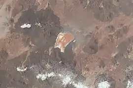 Laguna Colorada and Ch'iqu (upper left) as seen from the ISS (north is to the upper left part of this image) | |
| Highest point | |
| Elevation | 5,475 m (17,963 ft) [1] |
| Coordinates | 22°01′57″S 67°45′38″W |
| Geography | |
 Ch'iqu Location in Bolivia | |
| Location | Bolivia Potosí Department |
| Parent range | Andes |
References
- Bolivian IGM map 1:50,000 Volcán Chico 6027-IV (see: Cerro Cahuana (Volcán Apagado))
- Clodoaldo Soto Ruiz, Runasimi-Kastillanu-Inlis Llamkaymanaq Qullqa, Ayakuchu-Chanka, I rakta, Quechua-Spanish-English Functional Dictionary, Ayacucho-Chanka, Vol I (chiqu)
- Teofilo Laime Ajacopa, Diccionario Bilingüe Iskay simipi yuyayk'ancha, La Paz, 2007 (Quechua-Spanish dictionary) , see: ch'iquy
- "San Pablo de Lípez". Archived from the original on January 28, 2016. Retrieved January 24, 2016.
Capital: Potosí | ||
| Provinces |  | |
| Municipalities (and seats) |
| |
This article is issued from Wikipedia. The text is licensed under Creative Commons - Attribution - Sharealike. Additional terms may apply for the media files.