Tomás Frías Province
Tomás Frías is a province in the northern parts of the Bolivian Potosí Department. Its capital is Potosí which is also the capital of the department. The province is named after the former president Tomás Frías Ametller.
Tomás Frías | |
|---|---|
Province | |
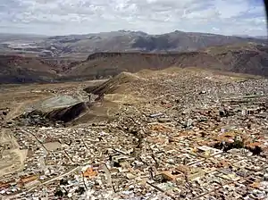 Potosí, capital of the Tomás Frías Province and the Potosí Department | |
 Flag  Seal | |
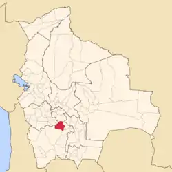 Location of the Tomás Frías Province within Bolivia | |
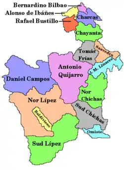 Provinces of the Potosí Department | |
| Coordinates: 19°23′23″S 65°54′34″W | |
| Country | |
| Department | Potosí Department |
| Capital | Potosí |
| Area | |
| • Total | 1,320 sq mi (3,420 km2) |
| Population (2001) | |
| • Total | 176,922 |
| • Density | 134/sq mi (51.7/km2) |
| • Ethnicities | Quechua Aymara |
| Time zone | UTC-4 (BOT) |
| Area code(s) | BO-P |
Location
Tomás Frías province is one of sixteen provinces in the Potosí Department. It is located between 19° 00' und 19° 50' South and between 65° 32' und 66° 24' West.
It borders Chayanta Province in the north, Oruro Department in the northwest, Antonio Quijarro Province in the southwest, José María Linares Province in the south, and Cornelio Saavedra Province in the east.
The province extends over 115 km from east to west and from north to south.
Geography
The Potosí mountain range traverses the province. Some of the highest mountains of the province are listed below:[1][2]
- Achakana
- Achakanani
- Chawpi Urqu (Potosí)
- Chawpi Urqu (Yocalla)
- Chuqi Kanlliyuq
- Jach'a Q'awa
- Jalsuri
- Janq'u Janq'u
- Jatun Ch'utu
- Jatun Pampa
- Jatun Qaqa
- Jatun Q'asa (Umallani)
- Jatun Q'asa (Yocalla)
- Kuntur Maña
- Kuntur Nasa (Tinguipaya)
- Kuntur Nasa (Yocalla)
- Kuntur Qaqa
- Kunturiri (Tinguipaya)
- Kunturiri (Yocalla)
- Lik'ichiri
- Malmisa
- Pari Chata
- Pä Qullu Punta
- Puka Qucha Punta
- Puka Urqu
- P'ukru
- Qiwiña Punta
- Qura Waña
- Q'illu Kancha
- Salla Punta
- Sayasta
- Turini
- T'inki
- T'ula P'ujru
- Wak'ani
- Wankarani
- Warmi Wañuna
- Waylla Tira
- Waylla Qullu
- Waylla Q'asa
- Waylla Unu
- Wayllita Punta
- Wayna Potosí
- Wayra Wasi
- Wayra Wasi (Potosí-Yocalla)
- Wichhu Qullu
- Wila Salla
- Wila Salla (Oruro-Potosí)
- Wila Sirka
- Yana Qaqa
- Yuraq Q'asa
- Yuraq Urqu
Division
The province comprises four municipalities which are further subdivided into cantons.
| Section | Municipality | Seat |
|---|---|---|
| Capital Municipality | Potosí Municipality | Potosí |
| 1st | Tinguipaya Municipality | Tinguipaya |
| 2nd | Yocalla Municipality | Yocalla |
| 3rd | Urmiri Municipality | Urmiri |
Population
The main language of the province is Spanish, spoken by 84.5%, while 75.5% of the population speak Quechua. The population increased from 167,111 inhabitants (1992 census) to 176,922 (2001 census), an increase of 20%. Capital of the province is Potosí (132,966 inhabitants).
28% of the population have no access to electricity, 50.5% have no sanitary facilities.
21% of the population are employed in agriculture, 8% in mining, 10% in industry, 61% in general services. 92% of the population are Catholics, 5% Protestants.
The people are predominantly indigenous citizens of Quechua and Aymara descent.[3]
| Ethnic group | Potosí Municipality (%) | Tinguipaya Municipality (%) | Yocalla Municipality (%) | Urmiri Municipality (%) |
|---|---|---|---|---|
| Quechua | 68,1 | 94,7 | 93,8 | 49,3 |
| Aymara | 2,0 | 0,2 | 0,4 | 46,6 |
| Guaraní, Chiquitos, Moxos | 0,2 | 0,0 | 0,1 | 0,0 |
| Not indigenous | 29,5 | 5,1 | 5,7 | 4,1 |
| Other indigenous groups | 0,2 | 0,0 | 0,1 | 0,1 |
See also
References
- Bolivian IGM maps 1:50,000 Carhuayo 6336-II, Don Diego 6435-I, Porco 6434-IV, Potosí (Este) 6435-II-1, Potosí (Oeste) 6435-III, Puna 6435-III
- Plan de Desarrollo Municipal Tinguipaya 2008 – 2012
-
- Potosí Department - social data of its provinces (PDF 5,36 MB) (spanish)
External links
Capital: Potosí | ||
| Provinces |  | |
| Municipalities (and seats) |
| |