Chayanta Province
Chayanta is a province in the northern parts of the Bolivian Potosí Department. Its capital is Colquechaca.
Chayanta | |
|---|---|
Province | |
 Ocurí, the seat of the Ocurí Municipality | |
 Flag  Seal | |
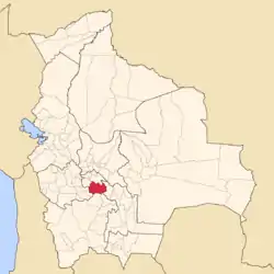 Location of the Chayanta Province within Bolivia | |
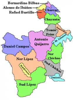 Provinces of the Potosí Department | |
| Coordinates: 18°44′S 65°51′W | |
| Country | |
| Department | Potosí Department |
| Municipalities | 4 |
| Cantons | 13 |
| Capital | Colquechaca |
| Area | |
| • Total | 1,919 sq mi (4,969 km2) |
| Population (2001) | |
| • Total | 90,205 |
| • Density | 47/sq mi (18.2/km2) |
| • Ethnicities | Quechua |
| Time zone | UTC-4 (BOT) |
| Area code(s) | BO.PO.CY |
%252C_Chayanta%252C_Potosi%252C_Bolivia.jpg.webp)
Location
Chayanta province is one of sixteen provinces in the Potosí Department. It is located between 18° 23' und 19° 6' South and between 65° 23' und 66° 19' West.
It borders Charcas Province in the north, Rafael Bustillo Province in the northwest, Oruro Department in the west, Tomás Frías Province in the south, Cornelio Saavedra Province in the southeast, and Chuquisaca Department in the east. The province extends over 125 km from east to west and 100 km from north to south.
Geography
Some of the highest mountains of the province are listed below:[1][2][3][4][5][6]
- Apachita
- Chullpa Q'asa
- Chullpa Urqu
- Ch'iyar Jaqhi
- Jatun Lluqhi
- Jatun Punta
- Jatun Urqu
- Katariri
- Kuntur Puñuna
- Kuntur Qaqa
- Lluxita
- Markawi
- Muyu Urqu
- Palta Urqu
- Pastu Urqu
- Pata Urqu
- Puka Q'asa
- Puka Urqu
- Q'illu Qaqa
- Q'illu Wasi
- Sankayu
- Sikuyayuq
- Siwinqani
- Tullu Muqu
- Ura Urqu
- Urqu Pata
- Wathiya Punta
- Wayra Wasi
- Wichhu Qullu
- Wila Jaqhi
- Wisk'achani
- Wisk'achani Punta
- Yana Qaqa
- Yana Urqu
- Yuraq Urqu
History
In the late eighteenth century the province was the scene of a rebellion of the Aymara-speaking population led by Tomás Katari and exacerbated by his assassination in January 1781. It was also the scene of a peasant rebellion in 1927.
Division
The province comprises four municipalities, which are partly further subdivided into cantons.
| Section | Municipality | Seat |
|---|---|---|
| 1st | Colquechaca Municipality | Colquechaca |
| 2nd | Ravelo Municipality | Ravelo |
| 3rd | Pocoata Municipality | Pocoata |
| 4th | Ocurí Municipality | Ocurí |
Population
The main language of the province is Quechua, spoken by 79%, while 33% of the population speak Spanish. The population increased from 73,128 inhabitants (1992 census) to 90,205 (2001 census), an increase of 23.4%. The capital of the province is Colquechaca.
97% of the population have no access to electricity, 98% have no sanitary facilities.
74% of the population are employed in agriculture, 1% in mining, 13% in industry, 12% in general services. 93% of the population are Catholics, 5% Protestants.
The people are predominantly indigenous citizens of Quechua descent.[7]
| Ethnic group | Colquechaca Municipality (%) | Ravelo Municipality (%) | Pocoata Municipality (%) | Ocurí Municipality (%) |
|---|---|---|---|---|
| Quechua | 95.3 | 94.4 | 89.6 | 93.4 |
| Aymara | 0.9 | 0.3 | 3.0 | 0.2 |
| Guaraní, Chiquitos, Moxos | 0.0 | 0.1 | 0.0 | 0.2 |
| Not indigenous | 3.8 | 5.2 | 7.3 | 6.1 |
| Other indigenous groups | 0.0 | 0.1 | 0.0 | 0.1 |
Literature
- Sergio Serulnikov, Subverting Colonial Authority: Challenges to Spanish Rule in Eighteenth-Century Southern Andes (Durham: Duke University Press, 2003)
- Sergio Serulnikov, Tomás Catari y la producción de justicia (Buenos Aires: CEDES, 1988)
- Erick D. Langer, "Andean Rituals of Revolt: The Chayanta Rebellion of 1927," Ethnohistory 37(1990): 227–53
- Tristan Platt, Estado boliviano y ayllu andino: tierra y tributo en el norte de Potosi (Lima: Instituto de Estudios Peruanos, 1982)
References
- Bolivia IGM map 1:50,000 Ravelo 6437-I
- Bolivia IGM map 1:50,000 Sapsi 6537-IV
- Bolivia IGM map 1:50,000 Toromani 6438-II
- "Colquechaca". INE, Bolivia. Retrieved April 17, 2016.
- "Ocuri". INE, Bolivia. Archived from the original on April 1, 2016. Retrieved April 17, 2016.
- "Ravelo". INE, Bolivia. Archived from the original on March 4, 2016. Retrieved April 17, 2016.
- obd.descentralizacion.gov.bo/municipal/fichas/ (inactive)
See also
Capital: Potosí | ||
| Provinces |  | |
| Municipalities (and seats) |
| |