Tahua Municipality
Tahua Municipality is the second municipal section of the Daniel Campos Province in the Potosí Department in Bolivia. Its seat is Tahua.
Tahua Municipality
Tawa | |
|---|---|
Municipality | |
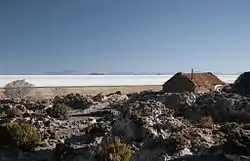 The village of Coquesa and Salar de Uyuni in Tahua Municipality | |
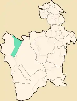 Location within Potosí Department | |
 Tahua Municipality Location within Bolivia | |
| Coordinates: 20°18′S 67°24′W | |
| Country | |
| Department | Potosí Department |
| Province | Daniel Campos Province |
| Seat | Tahua |
| Area | |
| • Total | 1,263 sq mi (3,272 km2) |
| Elevation | 12,100 ft (3,700 m) |
| Population (2001) | |
| • Total | 2,166 |
| • Ethnicities | Aymara |
| Time zone | UTC-4 (-4) |
Geography
Tahua Municipality lies in the Altiplano at the Uyuni salt flat.
Some of the highest mountains of the municipality are listed below:[1]
- Ch'iyar Qullu
- Jisk'a Wat'a
- Lluqu Lluqu
- Muruq'u Qullu
- Wila Qullu
- Wila Wilani
Subdivision
The municipality consists of the following cantons:
The people
The people are predominantly indigenous citizens of Aymara descent.[2]
| Ethnic group | % |
|---|---|
| Quechua | 6.0 |
| Aymara | 90.5 |
| Guaraní, Chiquitos, Moxos | 0.1 |
| Not indigenous | 3.3 |
| Other indigenous groups | 0.0 |
See also
References
- "Tahua". INE, Bolivia. Retrieved October 16, 2015.
- obd.descentralizacion.gov.bo/municipal/fichas/ (inactive)
External links
Capital: Potosí | ||
| Provinces |  | |
| Municipalities (and seats) |
| |
This article is issued from Wikipedia. The text is licensed under Creative Commons - Attribution - Sharealike. Additional terms may apply for the media files.
