Chaharmahal and Bakhtiari Province
Chaharmahal and Bakhtiari Province (Persian: استان چهارمحال و بختیاری, Ostān-e Chahār-Mahāl-o Bakhtiyārī ) is one of the 31 provinces of Iran. It lies in the southwestern part of the country. Its capital is Shahr-e Kord.
Chahar Mahaal and Bakhtiari Province
استان چهارمحال و بختیاری | |
|---|---|
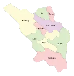 Counties of Chaharmahal and Bakhtiari Province | |
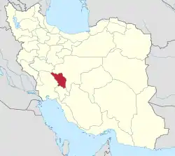 Location of Chaharmahal and Bakhtiari Province in Iran | |
| Coordinates: 32.3275°N 50.8546°E | |
| Country | |
| Region | Region 2[1] |
| Capital | Shahrekord |
| Counties | 10 |
| Government | |
| • Governor | Eghbal Abasi |
| Area | |
| • Total | 16,332 km2 (6,306 sq mi) |
| Population (2016)[2] | |
| • Total | 947,763 |
| • Density | 58/km2 (150/sq mi) |
| Time zone | UTC+03:30 (IRST) |
| • Summer (DST) | UTC+04:30 (IRST) |
| Main language(s) | Bakhtiari Lurish Persian Qashqai Turkish |
| HDI (2017) | 0.798[3] high · 13th |
| Year | Pop. | ±% |
|---|---|---|
| 1966 | 298,448 | — |
| 1986 | 631,179 | +111.5% |
| 2006 | 857,910 | +35.9% |
| 2011 | 895,263 | +4.4% |
| 2016 | 947,763 | +5.9% |
| amar.org.ir | ||
The province was classified as part of Region 2 upon the division of the provinces into 5 regions solely for coordination and development purposes on June 22, 2014.[1]
It has an area of 16,332 square kilometers, and had a population of 947,763 in 2016.[4]
The history of the province is tied largely to that of the Bakhtiari tribe. The Bakhtiari tribe can be divided into two sub-tribes, Haft Lang and Chahar Lang, with various territorial affiliations. They are the main speakers of Luri language.
Languages
Bakhtiāri, which belongs to the Southwestern branch of the Iranian language family, is the province's main language. Bakhtiāri is primarily spoken in the valleys of the higher areas in the western half of the province. It is also spoken in the lower areas around Lordegān in the south, and by speakers who have moved into the cities in the north-east.[5][6][7]
In the north-east quarter of the province, people in most cities and villages speak either Chārmahāli (also in the Southwestern branch of Iranian) or Turkic. Chārmahāli is transitional between Bakhtiari and Persian varieties of Esfahan Province, but more similar to the latter. Chārmahāli varieties spoken in cities include Dehkordi (in Shahr-e Kord), Ghafarrokhi (in Farrokh Shahr), Heysheguni (in Hafshejān), and Borujeni (in Borujen). There are also many other varieties of Chārmahāli spoken in rural areas. Most types of Turkic spoken in this province are similar to Qashqa’i of Fars Province, but they are transitional to the Āzarbāyjāni (Azerbaijani) language of north-west Iran. The Chārmahāli and Turkic language areas overlap with one another, and in the foothills of the Zagros and in the larger cities, they intermingle with Bakhtiāri as well.[5]
Tehrani-type Persian is now being taught by parents to children as a first language in some parts of the province, with the highest concentrations in the cities.[5]
The Atlas of the Languages of Iran (ALI)[8] published a series of language maps for Chahar Mahal va Bakhtiari Province, including a point-based and polygon (area-based) language distribution maps, and several linguistic data maps.[9][10][11] Written descriptions of some of the Bakhtiāri varieties in the province[12][13] and a lexicon of the Bakhtiāri language[14] have also been published.
Administrative divisions
Counties (Shahrestans)
| Map | Shahrestan (≈County) | Bakhsh (≈District) | District Center |
|---|---|---|---|
| Ardal | Central | Ardal | |
| Miankooh | Sarkhun | ||
| Boroojen | Central | Boroojen | |
| Boldaji | Boldaji | ||
| Gandoman | Gandoman | ||
| Farsan | Central | Farsan | |
| Koohrang | Central | Chelgerd | |
| Bazoft | Bazoft | ||
| Doab-Samsami | Samsami | ||
| Kiar | Central | Shalamzar | |
| Naghan | Naghan | ||
| Lordegan | Central | Lordegan | |
| Falard | Mal-e Khalifeh | ||
| Khanmirza | Aluni | ||
| Manj | Manj | ||
| Shahr-e Kord | Central | Shahr-e Kord | |
| Ben | Ben | ||
| Laran | Soureshjan | ||
| Saman | Saman |
Natural attractions
Chaharmahal and Bakhtiari province is the source and birthplace of many springs, rivers and waterfalls that supply the water of the two great and vital rivers of Zayanderud and Karoon and cause the development of many cities in the country. Natural attractions include Zayanderud river, Zamankhan bridge, Kouhrang 1 Dam, Dime spring, Sheik Ali Khan waterfall, Chama Ice cave, Darkesh varkesh canyon, Rostam Abad Sardab spring, Do Polan, Karoon-4 dam, Darreh Esgh (love valley), Atashgah waterfall, Choghakhor Wetland, Pire Ghar cave, Siasard spring, Helen protected area, Barm spring, Sendegan spring, Tang Sayyad national Park, Parvaz national park, Sarab cave, Gandoman wetland, Zard lime waterfall, Kordikon waterfall.[15]
Economy
The province is mainly active in the agriculture sector. Most of the industrial sector is clustered around the center of the province.
The province has the potential to become a vibrant tourist attraction because of its natural resources.[16]
Colleges and universities
- Islamic Azad University of Borujen
- Islamic Azad University, Shahrekord Branch[17]
- Shahrekord University
- Shahrekord University of Medical Sciences
References
- "استانهای کشور به ۵ منطقه تقسیم شدند". همشهری آنلاین. June 22, 2014. Retrieved July 21, 2019.
- "National census 2016". amar.org.ir. Retrieved 2017-03-14.[]
- "Sub-national HDI - Area Database - Global Data Lab". hdi.globaldatalab.org. Retrieved 2018-09-13.
- "Archived copy" (PDF). Archived from the original (PDF) on 2013-05-31. Retrieved 2013-09-28.CS1 maint: archived copy as title (link) National Census 2011
- Geomatics and Cartographic Research Centre, Carleton University. "Atlas built on CouchDb". iranatlas.net. Retrieved July 21, 2019.
- Geomatics and Cartographic Research Centre, Carleton University. "Atlas built on CouchDb". iranatlas.net. Retrieved July 21, 2019.
- In Erik Anonby, Mortaza Taheri-Ardali, et al. (eds.). 2015-2017. Atlas of the Languages of Iran. Ottawa: Geomatics and Cartographic Research Centre, Carleton University. Online address: http://iranatlas.net (retrieved December 3, 2017).
- Geomatics and Cartographic Research Centre, Carleton University. "Atlas built on CouchDb". iranatlas.net. Retrieved July 21, 2019.
- Anonby, Erik, Mortaza Taheri-Ardali, et al. (eds.). 2015-2017. Atlas of the Languages of Iran. Ottawa: Geomatics and Cartographic Research Centre, Carleton University. Online address: http://iranatlas.net (retrieved December 3, 2017).]
- Anonby, Erik, Mortaza Taheri-Ardali, et al. (eds.). 2015-2017. Atlas of the Languages of Iran: Chahar Mahal va Bakhtiari language map. Ottawa: Geomatics and Cartographic Research Centre, Carleton University. Online address: (retrieved December 4, 2017).
- Anonby, Erik, Mortaza Taheri-Ardali, et al. (eds.). 2015-2017. Atlas of the Languages of Iran: Languages of Chahar Mahal va Bakhtiari Province, Iran. Ottawa: Geomatics and Cartographic Research Centre, Carleton University. Online address: (retrieved December 4, 2017).
- Khosravi, Abdol’ali. 1996/1375. Guyesh-e Bakhtiāri: Ketāb-e chahārom [Bakhtiari dialect: Fourth book]. Esfahan: Nashr-e Ghazal.
- Tāheri, Esfandyār. 2010/1389. Guyesh-e Bakhtiāri-ye Kuhrang [The Bakhtiari dialect of Kuhrang]. Tehran: IHCS Press.
- Madadi, Zohrāb. 1996/1375. Vāzhehnāmeh-ye zabān-e Bakhtiāri [Lexicon of the Bakhtiari language]. Tehran & Esfahan: Enteshārāt-e Āyāt.
- "A trip to Chaharmahal and Bakhtiari".
- "Choghakhor to become a tourist hub by 2008". www.payvand.com. Retrieved July 21, 2019.
- "Islamic Azad University Shahrekord Branch - About Shahrekord". August 15, 2011. Archived from the original on August 15, 2011. Retrieved July 21, 2019.
External links
| Wikimedia Commons has media related to Chaharmahal and Bakhtiari Province. |
- Official website of Chahar Mahaal and Bakhtiari Governorship
- Provincial Bureau for Budget, Planning, and Management (سازمان مدیریت و برنامه ریزی)
- Shahrekord Municipality (شهرداری شهرکرد)
- Provincial Bureau for Telecommunications (شرکت مخابرات)
- Provincial Bureau of Industries and Mines
- (in Persian) Provincial Department of Transportation (سازمان حمل و نقل و پایانهها)
- (in Persian) Provincial Bureau of Economics and Finance Affairs (سازمان امور اقتصادی و دارائی)
- (in Persian) Provincial Department of Education (سازمان آموزش و پرورش)
- Provincial Bureau of Taavon (اداره کل تعاون)
- Provincial Department of Utilities (سازمان آب وفاضلاب روستایی)
- Shahrekord Central Post Office (اداره کل پست)
- Provincial Department of Medical Insurance (بیمه خدمات درمانی)
- (in Persian) Provincial Bureau of Agricultural Jihad (سازمان جهاد کشاورزی)
- (in Persian) Provincial Welfare Organization (سازمان بهزیستی)
- (in Persian) Provincial Department of Social Security (اداره کل تامین اجتماعی)
- (in Persian) Provincial Meteorological Service (اداره کل هواشناسی)
- Chahar Mahal va Bakhtiyari Attractions
- Atlas of the Languages of Iran (ALI) - Chaharmahal and Bakhtiari
Places adjacent to Chaharmahal and Bakhtiari Province | ||||||||||
|---|---|---|---|---|---|---|---|---|---|---|
| ||||||||||
| Capital | 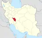 | ||||||||||||||||||||
|---|---|---|---|---|---|---|---|---|---|---|---|---|---|---|---|---|---|---|---|---|---|
| Counties and cities |
| ||||||||||||||||||||
| Landmarks |
| ||||||||||||||||||||
| populated places | |||||||||||||||||||||
| Authority control |
|---|