Kurdistan Province
Kurdistan Province or Kordestan Province (Persian: استان کردستان, romanized: Ostān-e Kordestān; Kurdish: پارێزگای کوردستان, romanized: Parêzgeha Kurdistanê[3][4]), is one of the 31 provinces of Iran. The province of Kurdistan is 28,817 km² in area. It is located in the west of Iran, in Region 3 and bound by Kurdistan Region of Iraq on the west, the province of West Azerbaijan to its north, Zanjan to the northeast, Hamedan to the east and Kermanshah to the south.[5] The capital of Kurdistan Province is the city of Sanandaj.[6]
Kurdistan Province | |
|---|---|
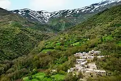 Miyane village | |
 Location of Kurdistan Province within Iran | |
| Coordinates: 35.3113°N 46.9960°E | |
| Country | |
| Region | Region 3 |
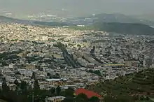
| Capital | Sanandaj |
| Counties | 10 |
| Government | |
| • Governor | Bahman Moradnia |
| Area | |
| • Total | 29,137 km2 (11,250 sq mi) |
| Population (2016)[1] | |
| • Total | 1,603,011 |
| • Density | 55/km2 (140/sq mi) |
| Time zone | UTC+03:30 (IRST) |
| • Summer (DST) | UTC+04:30 (IRST) |
| HDI (2017) | 0.743[2] high · 30th |

Demographics
The population of the province in 1996 was 1,346,383 of which 52.42% were urban dwellers and 47.58% rural dwellers. According to National Census, the population increased to 1,493,645 out of which 66% lived in urban area.[1]
Kurds are the majority of the population, but Azerbaijanis populate the eastern provincial borderlands. Most of the Kurdish population speak Sorani Kurdish, but Southern Kurdish is spoken in the eastern parts of the province, including in Bijar and Dezej, while Gorani is the main language in many villages in the southwestern part of the province. A distinct Azerbaijani dialect is the dominant language in the far-eastern part of the province, including in the cities of Delbaran, Pir Taj, Serishabad, Yasukand and Tup Aghaj. While not being the primary language in any settlement in the province, Persian is increasingly becoming the first language, especially among the population in the eastern parts of the province.[7]
History
The earliest human occupation of Kurdistan dates back to Paleolithic Period when Neanderthal man lived in the Sirwan Valley of Kurdistan more than 40,000 years ago.[8] The mountainous lands of this area first encouraged Iranian-speaking tribes to settle in this region after their immigration to Iran. It was from here where the first plan to overthrow the Assyrian Empire began, leading to their defeat in 612 BCE, and setting the stage for the start of the Median empire.
During the next few hundred years, the area of present-day Kurdistan Province became the arena of conflict between various invaders, including the Mongols and Timurids. Its steady decline began in the 16th century, when sea traffic replaced the famous Silk Road.
Upon the order of Sultan Muhammad Khodabandeh (Öljaitü), a small town by the name of Soltanabad Chamchal was constructed in Bisotun region to function as the official and political center of Kurdistan in the Middle Ages. It remained the capital for nearly one-and-a-half centuries, until, in 1372 CE, the government moved to Hassanabad fort, 6 km south of Sanandaj. Around 14th century, people from Ardalan tribe established themselves in Sanandaj as the rulers of this region.
According to Sharafnama written by Sharaf al-Din Bitlisi, the earliest known leader of the tribe, Bawa Ardalan, was a descendant of Ahmad bin Marwan, who ruled in Diyarbakır. He settled down among the Guran in Kurdistan and toward the end of the Mongol period took over the Sharazor region, where he established himself as an absolute ruler. He is considered to be the founder of the Ardalan principality. The territories of Zardiawa (Karadagh), Khanaqin, Kirkuk, and Kifri, which were already the homelands of the Goran-Kurds, all belonged to this principality. The capital city of the principality was first in Sharazor, but was moved to Sinne later on. During the reign of Shah Ismail I, the founder of Safavid dynasty, Sunni Kurds (among them the Ardalans) were supported by Ottoman against the Shi'ite government of the Safavids. When Soleiman Khan Ardalan came to power in 1630 CE, the throne was transferred to Sanandaj (Sinne), and, from then on, the rulers contributed to the flourishing and development of the area.
The Ardalan Dynasty continued to rule the region until the Qajar monarch Nasser-al-Din Shah (1848-1896) ended their rule in 1867 CE.
The area of Kurdistan Province incorporates portions of the former Gerrus Province.
Geography
Kurdistan Province is a mountainous region that can be topographically divided into a western and an eastern section at Sanandaj. As a result of its elevation and mountains, Kurdistan province has many rivers, lakes, glaciers and caves, which render it rather picturesque. Consequently, Kurdistan has always attracted many tourists and fans of mountaineering, ski and water-sports.
The Zarrineh River, 302 km long, is one of the longest rivers of this province. Its banks offer great opportunities for recreation and the river's plentiful water renders itself ideal for water sports. This river runs northwards and ultimately pours into Lake Urmia. The Sirvan River is another prominent river in this province. It runs over a long distance, eventually to join the Tigris in Iraq. The banks of this river are remarkably attractive. The Simineh River is also an important river in this province. Many marine species and birds live on the banks of the province's numerous rivers which they seem to find ideal habitats.
Lake Zarivar is a water-way which lies at the feet to high mountains, providing a delightfully picturesque sight. Its water is sparkling and fresh. The lake has a maximum depth of 50 m and an average depth of 3 m. It is surrounded by thick forests. The lake, the mountains and the forests create a scenic panorama. This lake, which has a length of 5 km and a maximum which width of 1.7 km, lies to the west of Marivan. Lake Vahdat's dam, to the north of Sanandaj (Sinne), provides excellent opportunities for fishing and water-sports.
Kurdistan Province benefits from many resourceful mineral water springs. The most outstanding of these are: Govaz to the northwest of Kamyaran, Abetalkh close to Bijar and Baba Gorgor to the north of Qorveh.
Cave Kereftoo, close to Divandarreh, is a unique natural and at the same time archeological site. Inside the cave there are a number of ancient buildings known as the Temple of Heraclius, because the name of this Greek god is carved on the ceiling of one of the halls. Cave Shoovi, 267 m long, is another prominent cave, which lies near the city of Baneh.
Mount Charkhaln 3,330 m high, mount Chehelcheshmeh, 3,173 m, Mount Hossein Bak, 3,091 m, and Mount Masjede Mirza, 3,059 m, are the other large mountains of Kurdistan.
Administration

Kurdistan Province (Kordestan Ostan) is sub-divided into 10 counties (shahrestan), with populations as follows at the 2006, 2011, and 2016 Censuses. Each county is named after the city or town which is its administrative capital.
| Kurdistan Counties |
Population at 2006 Census |
Population at 2011 Census |
Population at 2016 Census |
|---|---|---|---|
| Sanandaj | 417,177 | 450,167 | 501,400 |
| Dehgolan | * | 62,844 | 64,015 |
| Saqqez | 208,425 | 210,820 | 226,451 |
| Marivan | 153,271 | 168,774 | 195,262 |
| Kamyaran | 105,895 | 105,996 | 102,856 |
| Baneh | 118,667 | 132,565 | 158,690 |
| Divandarreh | 82,741 | 81,963 | 98,040 |
| Qorveh | 199,622 | 136,961 | 140,192 |
| Bijar | 97,913 | 93,714 | 89,162 |
| Sarvabad | 54,832 | 49,841 | 44,940 |
| Totals for province | 1,440,156 | 1,492,645 | 1,603,011 |
- 2006 population included in figure for Qorveh County, from which it was split off in 2007.
Economy
The major activities of the inhabitants are agriculture and modern livestock farming. Wheat, barley, grains and fruits are the major agricultural products. The chemical, metal, textile, leather and food industries are the main industrial activities in this province. This province has one of the largest rates of unemployment in Iran. According to Iranian statistics, more than twenty thousand people depend on being a kolbar for sustenance.[9]
Colleges and universities
See also
References
- Selected Findings of National Population and Housing Census 2011 Archived 2013-05-31 at the Wayback Machine
- "Sub-national HDI - Area Database - Global Data Lab". hdi.globaldatalab.org. Retrieved 2018-09-13.
- "ئەنجوومەنی دادوەری ئێران بەدواداچوون بۆ دۆسیەی گەندەڵی لە پارێزگای کوردستان دەکات". Naskurd (in Kurdish). Retrieved 18 March 2020.
- "Parêzgeha Kurdistanê qaremana pêşbirkên werzişên zorxaneyî yên Îranê". Sahar. 16 September 2017. Retrieved 18 March 2020.
- "همشهری آنلاین-استانهای کشور به ۵ منطقه تقسیم شدند (Provinces were divided into 5 regions)". Hamshahri Online (in Persian). 22 June 2014. Archived from the original on 23 June 2014.
- "Sanandaj". Britannica. Retrieved 17 November 2020.
- Mohammadirad, Masoud (2016). "Language distribution: Kordestan Province". Iran Atlas.
- Biglari, F and S. Shidrang (2019) Rescuing the Paleolithic Heritage of Hawraman, Kurdistan, Iranian Zagros, Near Eastern Archaeology 82 (4): 226-235.https://doi.org/10.1086/706536
- Fars News:The situation of kolbars vaguer than ever
External links
| Wikimedia Commons has media related to Kurdistan Province. |
| Wikivoyage has a travel guide for Kurdistan (province). |
| Wikisource has the text of a 1911 Encyclopædia Britannica article about Kurdistan Province. |
Places adjacent to Kurdistan Province | |
|---|---|
| Capital | 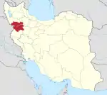 | ||||||||||||||||||||
|---|---|---|---|---|---|---|---|---|---|---|---|---|---|---|---|---|---|---|---|---|---|
| Counties and cities |
| ||||||||||||||||||||
| Sights |
| ||||||||||||||||||||
| populated places | |||||||||||||||||||||
| Authority control |
|---|
