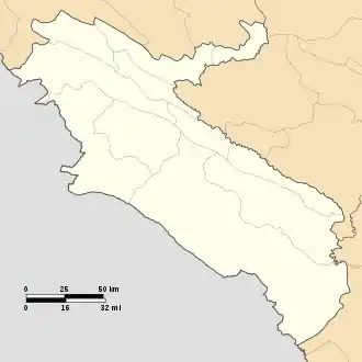
Ilam Province
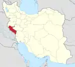
Ilam Province (Persian: استان ایلام, Kurdish: Parêzgeha Îlamê ,پارێزگای ئیلام[10][11]) is one of the 31 provinces of Iran. It is located in the western part of the country in Region 4 and covers 20,164.11 km2 (7,785.41 sq mi), while sharing 425 km (264 mi) of the border with Iraq, and also bordering on the provinces of Kermanshah, Lorestan, and Khuzestan. The largest city and also the provincial capital is the city of Ilam with a population 194,030. As of 2016 census, the population of the province was 580,158 people and is the least populated province in Iran.[12]
Ilam Province | |
|---|---|
 Ilam Province | |
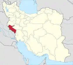 Location of Ilam Province in Iran | |
| Coordinates: 33.6384°N 46.4226°E | |
| Country | |
| Region | Region 4 |
| Founded | 1974 |
| Capital | Ilam |
| Counties | |
| Government | |
| • Body | Provincial Government |
| • Governor-general | Qasem Soleimani Dashtaki (Reformist) |
| Area | |
| • Province | 20,164.11 km2 (7,785.41 sq mi) |
| • Urban | 30.13 km2 (11.63 sq mi) |
| Area rank | 22nd |
| Latest measurement in 2019 | |
| Highest elevation [4] (Kan Seifi Peak) | 2,775 m (9,104 ft) |
| Lowest elevation | 36 m (118 ft) |
| Population (2016)[1] | |
| • Province | 580,158 |
| • Estimate (2020)[6] | 602,000 |
| • Rank | 31st (last) |
| • Density | 29/km2 (75/sq mi) |
| • Urban | 395,263 |
| • Rural | 184,444 |
| Time zone | UTC+03:30 (IRST) |
| • Summer (DST) | UTC+04:30 (IRST) |
| Postal code | 69311–69991[7] |
| Area code(s) | +98 84 |
| Vehicle registration | Iran 98[8] |
| HDI (2017) | 0.815[9] very high · 8th |
| Website | Ilam Portal |
Etymology
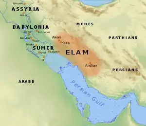
Ilam was named after the pre-historic civilization of "Elam" that lived in the areas in present-day southwest Iran for millennia, between 2700 and 539 BC.
For a long time, the area of the present-day Ilam province was called 'Poshtkouh' and along with 'Pishkouh', constituted Lorestan. When Hossein Qoli Khan was the ruler of Poshtkouh, it was also known as 'Hossein-Abad'. During the reign of Reza Shah in September 1929, following the approval of the Cabinet of the time, 'Hossein-Abad' village was renamed to 'Ilam' "to commemorate the magnificence and glory of the ancient civilization of Elam."[13] Later in 1937 it was declared a town.[14]
Demographics
Ilam Province has a diverse linguistic presence, albeit having the smallest population in Iran. This diversity derives from the geographical location of the province, positioned in the transitional zone between Kurdish and the Southwestern Iranian language bloc. The predominant language is Kurdish, more specifically the Southern Kurdish dialects Kalhori, Elami, Laki and the Khezeli dialect closely related to Laki. Kurdish is the dominant language in the cities of Ilam, Mehran, Eyvan, Abdanan, Sarableh, Lumar and Pahleh, and Cheshmeh-ye Shirin Shah Ahmad is the southern-most Kurdish-speaking settlement in the province.[15]
Luri is spoken in the southern parts of the province and is the predominant language in Murmuri, Haft Cheshmeh and many smaller villages. The city of Darreh Shahr has a Luri-speaking majority with a significant Kurdish-speaking minority. Two linguistically distinctive Luri dialects called Hinimini and Shuhani are also spoken in the province. Shahrak-e Changuleh is the largest Shuhani-speaking settlement, while Hinimini is spoken in and around Zarangush.[15]
Arabic is spoken in smaller settlements near the border to Khuzestan Province including in Shahrak-e Zu ol Faqari.[15]
A survey from 2015 found that the largest language in the province was Kurdish spoken by 85.7% of the population, followed by Luri with 10.7% and both Persian and Arabic with 1.8%.[16]
Kurdish tribes
The north is mostly inhabited by the Kurdish Kalhuri and Feyli tribes. The Feyli tribes include the Malekshahi, Khezel, Arkawâzi, Beyrey, Shuhan and Ali Sherwan tribes.[17]
Geography
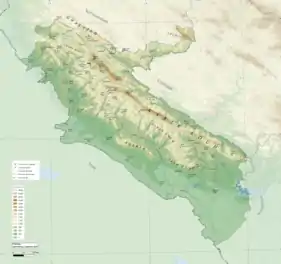
Ilam province, with an area of 20,150 km2 (7,780 sq mi), is the 22nd largest province in Iran. It is located in the southwest of the country, in Central Zagros, and is bordered by Iraq to the west, Khuzestan province to the south, Lorestan province to the east, and Kermanshah province to the north.
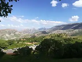
Ilam province is situated at the southwestern edge of Zagros mountains and right at the transition between the Arabian and the Iranian plateaus. Because of this, it is divided into two distinct natural areas; The northern and eastern parts are mountainous, whereas the southwest is covered with low plains that extend to the Iraqi and Khuzestan borders.
The mountains in the north and east are mostly parallel, running in the northwest–southeast direction. These mountains are separated by plains and rolling hills that are mostly used to grow crops and orchards by settlers.
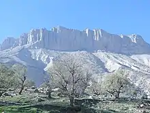
The most prominent mountain in Ilam province is Kabir Kouh, which is located in the eastern part of the province, stretching 160 km from near Pol-e Zal in the southeast to Mishkhas village near Ilam city in the northwest. The highest point in province, Kan Seifi peak with 2,775 m (9,104 ft) above sea level, is part of Kabir Kouh range.[18][19][20]
Other major mountains include:
- Manesht and Qolarang near Ilam;
- Sharah-Zoul and Bankoul in Eywan;
- Qalajeh and Ahuran in Chardavol.
- Dinar Kouh, in Abdanan;
- Anaran and Siah Kouh in central Dehloran;
- Laneh and Charmin near Lumar; and,
- Chaman-Ghir and Sivan near Mishkhas.[21]
| Peak | Elevation (m) | Elevation (ft) |
|---|---|---|
| Kan Seifi | 2775 | 9104 |
| Manesht | 2629 | 8625 |
| Chaman Ghir | 2578 | 8458 |
| Qolarangh | 2473 | 8114 |
| Ghachan | 2464 | 8084 |
| Bankoul | 2304 | 7559 |
| Melinjeh | 2193 | 7195 |
| Shalam | 2174 | 7133 |
| Sameleh | 2150 | 7054 |
Contrary to the north, the south and southwestern part of the province is covered with low-lying plains with elevation varying between 50 to 300 m (160 to 980 ft) above sea level. Despite receiving little precipitation, large areas of these low lands, notably Dehloran, Musian and Dasht Abbas, are cultivated owing to a combination of factors such as rivers flowing from the mountains to the east, dams and irrigation networks.
The Ghamasiab river, after running through Kermanshah province, flows toward Ilam. Upon arriving at the point where the borders of Ilam, Lorestan and Kermanshah provinces meet, it is named Seymareh. It then flows west and southward and somewhere near Kal Sefid Village, Darreh Shahr, is joined by the Kashkan river and together they create the Karkheh river, the third longest river in Iran with a length of around 755 km. Seymareh and Karkheh constitute the Ilam's eastern border with Lorestan province.
Because of the terrain, the permanent and seasonal rivers and stream that originate from Ilam highlands either fall into Seymareh, such as Chardavol, Garab, Seekan, Darreh Shahr and Majeen rivers; or, flow westword toward the low lands and into Iraq and Khuzestan, such as Ghanghir, Ghodar-Khosh, Kanjan-Cham, Roud Ghavi, Changouleh Meymeh, Murmuri, Doiraj and Siah Ghav rivers.[13]
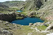
Apart from some few springs here and there, such as Siah-Ghav Twin Lakes near Abdanan, there are no major natural bodies of water in the province. There are, however, four dam that provide important drinking water, these include Ilam, Seymareh, Eywan and Doiraj dams.[22]
Flora
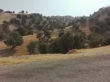
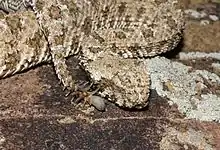
With about 31% of its territory covered with scattered to dense forests of mostly Persian oak, Ilam ranks 3rd in the country after Kohgiluyeh and Lorestan provinces, excluding the northern provinces of Mazandarn and Gilan.[23][24] The highlands and the forests of the province are the habitat of many animals including the Asian black bear, Caracal, Caucasian squirrel, Eastern imperial eagle, Golden eagle, Black kite, Black stork, Blunt-nosed viper, and the endangered Persian leopard.[25] Ilam is home to the endangered Spider-tailed horned viper, a unique species only found in Ilam province in the world.[26]
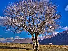
More than 6,400 km2 (2,500 sq mi) of the province, around 31% of its territory, is covered with scattered to dense forests. This is about one third of the total forests in the Zagros Mountains. The predominant species of these forests are Persian oak, though other trees such as wild almond, hawthorn, Persian turpentine, Montpellier maple and Judas can be found.
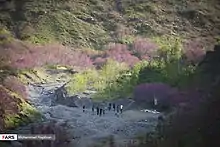
The Arghavan Canyon near Ilam is known for the pink blooms of the Judas-trees, which flower in Spring.
Fauna
Due to its geographical location, natural conditions and the diversity of its habitats, Ilam province is home to 32 mammals and 183 birds. The mountainous areas, specifically, host mammals such as:
- wild goat, Asiatic mouflon, Argali, goitered gazelle;
- the endangered Persian leopard and Asiatic cheetah;
- as well as Caracal, Eurasian lynx, Asian black bear, Brown bear, wolf, Golden jackal, Red fox and wild boar; and,
- smaller species such as Caucasian squirrel, rabbits, Long-eared hedgehog, European hedgehog, Indian crested porcupine and weasels.[27]
Ilam province is only area in the world in which the spider-tailed horned viper can be found.
Nature conservatories
About 13% of the total territory of Ilam province is under the protection and monitoring of local and national natural reserves organizations. There are four protected areas, which in total, cover 1,377 km2 (532 sq mi):
| Name | Designation | Closest community | Area |
|---|---|---|---|
| Kabir Kouh | Protected area | Darreh Shahr | 179 km2 (69 sq mi) |
| Dinar Kouh | Protected area | Abdanan | 406 km2 (157 sq mi) |
| Manesht and Qolarangh | Protected area | Ilam | 292 km2 (113 sq mi) |
| Koulak | Protected area | Mehran | 500 km2 (190 sq mi) |
In addition to the protected areas mentioned above, there is:
"Tang-e Bina and Bijar" hunting prohibited area: around 500 km2 (190 sq mi) in area, near Chavar;
"Arghavan Valley forest reserve" near Ilam city: known for its pink spring blossoms of Judas tree; and,
"Largh forest reserve": known for its Pterocarya fraxinifolia trees. These trees are usually found in the rain forests of Northern Iran, but surprisingly grow in this small patch of land in "Lart Valley" near Badreh.
And two nationally registered natural heritage sites:[28]
- Razyaneh Canyon: a deep and narrow canyon carved by streams in the rock beds near Chenar Bashi, 10 to 30 m (33 to 98 ft) deep, 2 to 10 m (6.6 to 32.8 ft) in width, 1.5 km (0.93 mi) long; and,
- Dehloran: an 1,400 ha (3,500 acres) area near Dehloran that includes hot water and bitumen springs, as well as 'bat caves'.
Landslides
One of the largest landslides in the eastern hemisphere and world is believed to have occurred in Ilam Province, more specifically, near Gorz-e Langar area of Darreh Shahr county. According to Harrison and Falcon in their article on Royal Geographical Society, published in 1937, the Seymareh landslide, moved as much as 30 km3 (7.2 cu mi) of earth, some found kilometres away. It is suspected that an earthquake could have triggered such a large landslide.[30][31][32]
Climate
Due to the influence of various factors such as altitude, proximity to the Arabian desert, the plains of Khuzestan and Iraq, the climate of the province is very diverse.
Different atmospheric systems affect the province, causing fall, winter, spring, and occasionally summer precipitation. The Mediterranean and Black Sea air masses from the west, trigger autumn and winter rains in the province.[33]
The Red Sea and Saudi desert currents, too, bring winter and spring rains. The very same currents and the vast Iraqi plain to the west are the main causes of hot weather in summers. On the other hand, the northern air masses entering the country in winter from Siberia lower the temperatures and cause freezing in northern parts of the province.
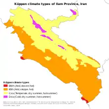
Ilam province is considered as one of the tropical regions of the country, but due to difference in altitudes, temperature and precipitation, three different types of climate can be observed:[13][33]
- Mountainous areas of the north and northeast, which have cold climate and long winters. The minimum temperature in winter reaches −15 to −20 °C (5 to −4 °F) and the amount of precipitation exceeds 600 mm (24 in) per year.
- The plains of the west and southwest of the province have dry hot climate. The maximum temperature in these areas can exceed 52 °C (126 °F). The rainfall in these areas is about 200 mm (7.9 in) per year.
- Other areas have temperature to warm climate with hot summers and mild winters. Temperatures can go as low as −15 °C (5 °F) in higher altitudes and in summers it can go above 45 °C (113 °F) in lower altitudes. Annual precipitation in these areas varies between 200 mm (7.9 in) to 450 mm (18 in).
| Town | July daily maximum | January daily maximum | Annual precipitation |
|---|---|---|---|
| Ilam | 38.2 °C (100.8 °F) | 10.5 °C (50.9 °F) | 585.4 mm (23.05 in) |
| Mehran | 45.6 °C (114.1 °F) | 16.3 °C (61.3 °F) | 230.4 mm (9.07 in) |
| Dehloran | 48.1 °C (118.6 °F) | 16.5 °C (61.7 °F) | 280.4 mm (11.04 in) |
| Darreh Shahr | 46.4 °C (115.5 °F) | 15 °C (59 °F) | 482.1 mm (18.98 in) |
| Eyvan | 38.8 °C (101.8 °F) | 11 °C (52 °F) | 704.1 mm (27.72 in) |
| Sarableh | 41.4 °C (106.5 °F) | 11.2 °C (52.2 °F) | 510.7 mm (20.11 in) |
| Abdanan | 42.5 °C (108.5 °F) | 12.9 °C (55.2 °F) | 613.7 mm (24.16 in) |
| Lumar | 45.2 °C (113.4 °F) | 13.2 °C (55.8 °F) | 460.3 mm (18.12 in) |
Flood

Occasional heavy rainstorms in spring and autumn bring, sometimes, huge floods. The steep slopes of Zagros Mountains, soil type, lack of vegetation are among some of the reasons why Ilam province is prone to flooding. Moreover, majority of communities in Ilam province are located in the floodplains, at the foothills of mountains, on river banks and near sources of water, so there is always risk of flooding with potential human and financial costs. According to the available statistics, Mehran and Dehloran counties are at the highest risk of flooding due to their lower elevation compared to the rest of the province and the subsequent concentration and joining of rivers and streams.
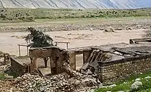
The latest flood happened in March and April 2019, in which most of country, including Ilam province, experienced levels of flooding. On April 1, 2019, the flood destructed many bridges including the Gavmishan bridge in Darreh Shahr, an important bridge over Karkheh River which connects south of the province to Lorestan and rest of the country. The bridge was reopened months later on October 6, 2019.[34]
Dust
Ilam is occasionally affected by dust, especially in summers. It has become more frequent in the last ten years. The cities of Mehran and Dehloran are at the highest risk in the province, due to lower elevation and proximity to the deserts of Iraq and Saudi Arabia. However, in case of large dust storms, the western part of the country could be affected. The successive droughts of the recent decade in Iran and the long wars in Iraq and Syria have also exacerbated the issue.[35][36]
History
Pre-history
The name "Ilam" comes from "Elam", the pre-historic civilization that ruled the area in modern southwest Iran from 2700 BC to 539 BC. Archaeological findings dates human settlement of the area to around 5000 BC.
Ashurbanipal, the then king of Assyria, invaded Elam in 639 BC and totally destroyed it. Although not as united as before, the Elamites survived and continued to live in the area after the invasion. Between 612 and 546 BC, Elam was incorporated into the Median Empire and later into the Achaemenid Empire in 539 BC. During the Achaemenid Empire, Elam lost its independence forever and became the third province of the empire after Persis and Media.[37]
During the reign of the Medes, Achaemenids, Seleucids and Parthians, owing to its proximity to the districts of Hamadan, Kurdistan, Kermanshah, Lorestan and, most notably, Susa, the area and its settlements took on importance.
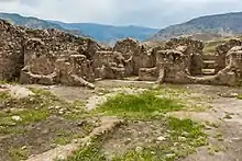
During the Sassanid era, the present-day Ilam was composed of two states: Mehrjanqazaq in the east, which was the modern day Darreh Shahr and Masbasan in the west.[38]
Arabs
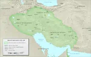
After the Muslims conquest of Mesopotamia in 640 AD, the Arabs named the area the "Land of the Mountains," or "Jibal". During the Arabs' rule, the kingdom of Jibal, whose capital was Seymareh, was one of the territories under the control of Baghdad and Basra, and lasted until 961 CE.
The Rashidun Caliphate conquered Mesopotamia by 640 CE and later the whole Sasanid Empire by 643 CE and kept the control until their collapse in 661 CE. Prior to their collapse, civil war had taken over the caliphate, after which Muawiyah faction won and thus established the Umayyad Caliphate. The Umayyad controlled the area until their own collapse in 750 AD, after which the Abbasid Caliphate took over and reigned for around two hundred years until 945 CE. After conquering the western Iran in 945 CE, the Buyid Dynasty ruled over this area until 1055.
Kurds
From 961 to 1015, the Ḥasanwayhid dynasty ruled over western Iran under the influence of the Buyid Dynasty. Centred at Dinawar, near present-day Kermanshah, Hasanwyhids, Kurdish Muslims with ties to the Kurdish Barzikani tribe, controlled central areas of the Zagros Mountains. At its greatest extent, the dynasty included the modern-day areas around Khorramabad, Borujerd, Nahavand, Asadabad, Borujerd, Ahwaz, Ilam, Kermanshah, Hulwan and Kirkuk. The Ḥasanwayhid dynasty was overthrown by the Annazids, who, with help of the Buyid dynasty, controlled the area until their collapse in 1116 CE.[39] It is probable that the Kakuyids were in control of the area until 1140.
Lurs
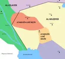
For 270 years, between 1155 and 1424, the Hazaraspids reigned the Zagros Mountains, especially areas around Lorestan. Hazaraspids who are also known as Lorestan Atabegs were composed of two groups, the Little Lor, who were mostly of Lor descent and Big Lor Atabegs who were of Kurdish descent. The former controlled parts of present-day provinces of Markazi, Hamedan, Kermanshah, Lorestan, Khuzestan and Ilam.
The capital of Little Lor was Shapourkhwast or the modern-day Khorramabad, especially the Falak-ol-Aflak Castle. The Little Lor Atabegs or the Khorshidi dynasty ruled over the area for over 412 years, from 1184 to 1597 CE, after which Shah Abbas the Great executed the last ruler, Shahverdi Khan, and replaced Shahverdi's nephew, Hossein Beyg/Khan, thus ending the rule of Little Lor and beginning of the Vali/Wali dynasty also known as Feyli Vali.[40]
During the Qajar era, Lorestan was divided into two regions: Poshtkouh (present-day Ilam province) with the center of Ilam city and Pishkouh (present-day Lorestan) with the center of Khorramabad. Poshtkhouh literally means “back of mountain” and it was due to the fact that Ilam was situated at the westernmost parts of the Zagros Mountains and to the rest of the country it was plainly considered at the back of mountains.[41]
From that point on, Ilam was ruled independently from Lorestan, and the governor reported directly to the central government, thereby ending Lorestan control of Ilam and Poshtkouh. The two districts were later renamed "Deh-e Bala" and "Deh-e Pa'een", which basically means the upper and lower villages.[41][42] During the rule of Hossein Qoli Khan over "Deh-e Bala" (1863-1900 CE), it was renamed to "Hossein-Abad Poshtkuh".
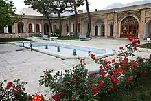
The Vali Castle of Ilam was built by the next Vali, Gholamreza Khan Feyli, in 1908. The castle is now a nationally registered heritage and also the Ilam Museum of Anthropology.
20th century
Following the establishment of the Pahlavi dynasty in 1925, Reza Shah suppressed the local governments to consolidate his dominance. In 1928, the government forces took over Poshtkouh and Gholamreza Khan Feyli, the last Feyli governor left Poshtkouh with any resistance and went to Iraq, thus abolishing the rule of the Feylis in Ilam after 332 years.[42] A year later, in 1929, "Hossein-Abad" was renamed to "Ilam" by the suggestion of Academy of Persian Language and Literature.[43]
On November 7, 1937, the parliament passed a law on the political division of the country under the title of "Act of Division of the Country and the Duties of the Governors", thereby dividing the country into 6 provinces and 50 counties.[44] Poshtkouh, being a county, was part of the "West Province".
The 1937 political division law did not last long and a while later on January 9, 1938, an amendment was passed which divided the country into 10 province and 49 counties. Based on the new division, "Ilam" was a county of the "Fifth Province".
In 1964, Darreh Shahr, Abdanan and Dehloran from Lorestan province and Mousian from Khuzestan were annexed to Ilam, thus upping its status to "general governorate" as part of the Kermanshah Province.[43] Ilam subsequently became a province in March 1974.
After the Islamic Revolution, Ilam was of the main battlegrounds of the Iran-Iraq war for years. The war began with the Iraqi invasion of western and southwestern parts of Iran on September 22, 1980. As a border province, Ilam was a constant target for the Iraqi bombing campaign and suffered heavily in terms of economic infrastructure. The war left Ilam province devastated for years, making it one of the least developed provinces in Iran.
Demographics
| Year | Pop. | ±% |
|---|---|---|
| 1956 | 110,067 | — |
| 1966 | 148,307 | +34.7% |
| 1976 | 246,024 | +65.9% |
| 1986 | 382,091 | +55.3% |
| 1991 | 440,693 | +15.3% |
| 1996 | 487,886 | +10.7% |
| 2006 | 545,787 | +11.9% |
| 2011 | 557,599 | +2.2% |
| 2016 | 580,158 | +4.0% |
| Est. 2020 | 602,000 | +3.8% |
| Notes: As Ilam Census Area in 1956 and Ilam General Governorate in 1966. Source: Statistical Center of Iran | ||
According to the latest census of 2016, Ilam province had a total population of 580,158, living in 159,310 households. Ilam province is the least populous province of Iran. With an area of 20,132 km2 (7,773 sq mi), the population density of Ilam was 28.8/km2 (75/sq mi) in 2016. Around 68% of the population live in urban areas. The gender distribution was 50.88% male in 2016. As of 2011, 99.62% of the population are Muslim.[45] Ilam city, also the provincial capital, with a population of 194,030, was the most populated community in Ilam province.
The population growth rate was at its peak in 70s at around 66%, but kept declining and reached its minimum in 2012 at 2.2%. In 2016, however, it increased to 4%.
Cities and towns
Ilam province is the least populated province in Iran. Ilam, the provincial capital, is the only city in the province and has a population of 194,030; All other towns have less than 35,000 population.
| Rank | Town | Pop. |
|---|---|---|
| 1 | Ilam | 194,030 |
| 2 | Dehloran | 32,941 |
| 3 | Eyvan | 31,299 |
| 4 | Abdanan | 23,946 |
| 5 | Darreh Shahr | 21,900 |
| 6 | Mehran | 17,435 |
| 7 | Sarableh | 12,393 |
| 8 | Arkavaz | 11,977 |
Culture
The original inhabitants of Ilam were the Guitians and the Kassites, and with the arrival of the Aryans in Iran, the Medes settled in the Zagros region. Throughout history, many people have settled and ruled in the region and as the result, today, Ilam is inhabited by Kurds, Lurs, Laks and Arabs. For the same reasons, the culture of the Ilamians is diverse, mostly a blend of many cultures.[36]
Language has had a very profound effect on the culture of the people; majority of people, about 80%, speak local dialects of Southern Kurdish, which is spoken in Kermanshah and Ilam. These people tend to have culture, clothing, music and literature that resemble that of Kermanshah. Lurs live in Darreh Shahr, Abdanan and Dehloran. Arabs live in Musian and Dasht Abbas. And, Laks live in Darreh Shahr and to a lesser extent in Holeylan.
It is important to note that variance and distinction between these different cultures has significantly faded over time, and, today drawing a clear line between each culture is difficult if not impossible. Kurds, Lurs and Laks have been living together in western Iran for millennia, so their cultures are integrated and hard to tell apart.
Handicrafts
.JPG.webp)
Embossed kilim is a combination of simple kilim and carpet knot in its text, which is considered as the most important and original handicraft in Ilam province.[47] Ilam's embossed kilim is different from other parts of the country. Upon its creation by Sahar Chalanghar, a resident of Zanjireh village of Sarableh county, Ilam's embossed kilim became popular both in Iran and the world. Now, there are more than 4,500 weavers of this specific type of kilim in Ilam province, producing around 3,000m2 annually. It is estimated that around 50% of those involved in all handicrafts work in Ilam province are in the field of kilim production.
"Ilam's embossed kilim" is different from other parts of the country because a weaver named "Sahar Chalangar", a resident of Zanjireh village (one of the functions of Sarablah city of Ilam province), succeeds in performing a prominent role in a part of his woven kilim by using a carpet knot. From this, a background is provided for the growth and promotion of embossed kilims. Ilam's embossed kilim has received a national hologram and has been registered as a souvenir and brand of Ilam province. Ilam was subsequently appointed as the national capital of embossed kilim.[47][48][49]
Government
The highest government authority of the province is the governor-general, who is appointed by the Minister of Interior given cabinet approval. The governor-general, subsequently appoints county governors. The incumbent governor-general is Qasem Soleimani Dashtaki, who is been in office since October 2017.
Administrative divisions
Ilam is divided into 11 counties, 28 districts and 52 rural districts.[52] Following the approval of the government cabinet, Holeylan county was established on Jan 4, 2020, having been a district of Chardavol county prior to that. Holeylan became the 11th county of Ilam.[53]
Economy
With about 0.99% contribution to the national GDP as of 2016, Ilam is one of the least developed provinces in Iran, ranked 26th out of 31. Most economic activities in the province are focused on agriculture and animal husbandry in the rural communities; and, skilled trades, public and private services in urban areas. The industry has a small share in the economy of the province and there are few factories.
Agriculture
The largest sector of Ilam's economy is agriculture, though much smaller compared to other provinces of Iran. There are more than 55,000 farmers in Ilam province. It is estimated that, about 50% of all households in the province are either directly or indirectly involved in agricultural activities.[54]
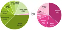
In 2018 harvest year, 223,228 hectares (551,610 acres) of land (11.1% of the territory of Ilam province) were cultivated for various crops such as wheat, barley, forage maize, corn, watermelon, melon and cucumber, producing 700,732 tons of produce in total, 14% through dry farming. Ilam is the bottom 3rd province in the country in terms of crop yield at 3.14 tons per hectare, only surpassing Kohgiluyeh and Kurdestan. For comparison, the average yield is 9.88 tons per hectare and highest is 25.64 tons per hectare in Alborz province.[55]
The farming lands of Ilam, like its geography, are divided; The northern and eastern parts of the province are mountainous and despite the presence of water resources, cultivable lands are limited to inter-mountain plains, foothills and river banks; On the contrary, the hot climate plains of the south and southwest such as Hojandan-Dasht, Amir-Abad, Mehran, Mosian, Dehloran and Dasht-Abbas, are large in size but limited in water resources.[56]
As of 2019, the total area of all orchards in Ilam province was 3,950 ha (9,800 acres), making it the last in the country. In total, these orchards produced 15,409 tons of fruits, or 0.1% of the country's production. The most grown horticultural products are: grapes, walnut, pomegranate, peach, olive and fig.[57]
Industry
| Rank. Province | Count |
|---|---|
| 1. Tehran | 6,806 |
| 2. Isfahan | 3,892 |
| 3. R. Khorasan | 2,164 |
| 29. S. Khorasan | 139 |
| 30. Kohgiluyeh | 65 |
| 31. Ilam | 52 |
The industry sector of Ilam's economy is poorly-developed even non-existent; As of 2017, the total number of industrial workshops (ten or more employees) in the province is just 52, 85% of which have under 50 employees. These workshops have 3,350, almost completely (96%) male, employees in total, accounting to a mere 0.6% of Ilam's population. As a comparison, the number of the same type of workshops is 6,806 for Tehran and 3,892 for Isfahan provinces, indicating how underdeveloped Ilam's industry sector is. According to the latest statistics, Ilam is the least industrial province in Iran.[59] In recent years, some efforts went into stimulating Ilam's industry by building industrial towns and areas, providing encouraging opportunities for businesses such as cheaper land, utilities and tax. Since 2005, 8 such towns and 5 areas have been built.[60]
The largest companies in Ilam province are:[61]
- Ilam Cement Company
- Ilam Petrochemical Company
- Ilam Gas Treating Company
- Madakto Steel Cord
- Sepid Morgh Manesht Industrial Slaughterhouse
- Atena Steel Manufacturing Company
- Ilam Syringe Production Company
- Pouyanakh Thread Manufacturing Company
- Koulak Mineral Water Company
- Several flour companies
Energy
With an estimated 14 trillion m3 of gas reserves and 17 billion barrels of oil reserve, equal to 6% and 11% of Iran's reserves respectively, Ilam ranks 2nd and 3rd in the country in terms of gas and oil. Ilam province produces more than 230,000 barrels of oil per day and 1.5 billion cubic meters of gas per year, accounting to about 90% of western Iran's oil and gas, making Ilam the energy hub of western Iran. The most important oil and gas fields in Ilam are: Dehloran, Tang-e Bijar, Chashmeh Khosh, Paydar-e Gharb, Azar and Danan. Despite the huge oil and gas reserves in the province, there are few downstream processing plants including:[62][63]
| Operating | Under construction | Planned |
|---|---|---|
|
|
|
Mining
Ilam province is part of the Zagros sedimentary structure and is completely covered with sedimentary rocks of different ages. In other words, there are no phenomena of magmatism and metamorphism in the province. Therefore, the province's metal mineral reserves are negligible. There are, however, substantial non-metallic reserves of gypsum, limestone, sandstone, dolomite, shale, bitumen, celestine, building stone and facade stone.[64] The province's gypsum is more than 99 percent pure and can be found in colossal amounts in Dehloran, Mehran and Bouli of Abdanan. Dehloran Gypsum Factory produces a premium quality product in the country.
The limestone reserves are also very significant in size and very high in purity (93-99.9%). Ilam Cement Factory, founded 1989 to use these mines, produces one of the finest cements in Iran and has won many national and international awards.[65] There are also large amounts of celestine discovered northwest of Dehloran. Celestine is used in oil well drilling industry.
The most valuable mineral in the province is bitumen. It is found as gilsonite and has a purity of more than 70%. Bitumen is found in Eyvan, Dehloran and Malekshahi counties.[64] Ilam province is the 2nd province in the country in terms of production and reserves of bitumen. Eyvan has the largest reserves of bitumen in the province and is considered the largest bitumen mine in the Middle East. Ilam's bitumen reserves are estimated at 465,000 tons proven and likely up to 900,000 tons.[66] In some places in the province, liquid bitumen seeps to the ground and creates springs. "Dehloran Bitumen Spring" is a nationally registered natural monument in Iran.[67]
Salt stone has been recovered in Baloutestan area of Zarin Abad. There's also veins of blue salt excavated near Dashtalak (Mimak) and Majeen (Darreh Shahr).
Given the geology of the province, building stones can also found in large amounts; White and black marble stone have been discovered near the city of Ilam.
About 2.2 million tons of mineral were excavated in 2019 and Ilam's reserves are estimated at around 1 billion tons.[68]
Education
The provincial department of education, in line with the Ministry of Education, supervises elementary and secondary education in the province. Higher education is supervised by the Ministry of Science, Research and Technology (Iran). As of 2019, there were 1778 schools and 112,503 students and 26,804 higher education students. As of 2016, the literacy rate in Ilam province was 89.1% for men and 80.6% for women.[2]
Higher education institutes in Ilam province:
- Ilam University of Medical Sciences
- Ilam University
- Islamic Azad University of Ilam
- Payame Noor University of Ilam
- Farhanghian University of Ilam:
- Campus of Shahid Modares
- Campus of Imam Jafar Sadegh
- Technical and Vocational University of Ilam
- University of Applied Science and Technology - Ilam Province Branch
- Bakhtar Higher Institution of Education
Healthcare
As of 2018, Ilam has one of the highest ratios of number of general practitioners to population in the country, ranking 2nd. There are 3.48 GPs per 10,000 population in Ilam province, the average of the country being 2.37. Ilam also has the highest ratio of dentists in the country.[46]
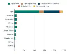
Despite the positively looking statistics when compared with other provinces, the medical facilities and expertise are unequally distributed in Ilam province; Ilam, the capital, serves as the medical hub in the province, hosting majority of hospitals, medical laboratories and specialist: Six of the 12 hospitals in the province; 23 of the 60 medical laboratories; 18 out of the 19 medical nuclear institutes; 123 out of the 189 specialists; all the post-specialist and professional doctorates; 13 out of 14 pharmacologists; and, the only medical university in the province are in Ilam.[46][69]
The most prominent hospitals of the province are:[70]
- Imam Khomeini Hospital
- Mostafa Khomeini Hospital
- Ayatollah Taleghani Hospital
- Kosar Private Hospital and Maternity Ward
- Ghaem Private Hospital and Maternity Ward
Transportation
Air
Compared to the rest of the country, Ilam is under-developed in term of transportation. The Ilam Airport is the only airport in the province. With 2850 sorties, 215,799 passengers and around 1,416 metric tons (1,561 short tons), Ilam Airport ranked 21st in the country and 2nd to Kermanshah Airport in the western region.[71] Built in 1996, Ilam Airport has regular flights to Tehran and Mashhad. In 2016, the airport was upgraded to international status (controlled airspace) and started a weekly service to Najaf.[72]
Road
As of 2019, there are only 179 km (111 mi) of highway in Ilam province:
 Road 17: Connecting Eslamabad-e Gharb to Mehran through Eyvan and Ilam.
 Road 19: Connecting Eslamabad-e Gharb to Road 37 near Pol-e Dokhtar in Lorestan with a small section of it passing through the northeastern bulge of Ilam province, the Chardavol County.
 Road 21: Connecting Ilam to Road 19 at Seymareh Bridge and then to Kermanshah.
 Road 64: Connecting the border city of Mehran to Dehloran and to Road 37 near Andimeshk in Khuzestan.
As of 2019, there were 10 road tunnels in Ilam province, the most important of which are:
- Qalajeh Tunnel: 2,583 m (8,474 ft) long, passing under Qalajeh mountain and the Ilam–Kermanshah border, part of Road 17. Opened in 2019;[73]
- Azadi Tunnel: 1,178 m (3,865 ft) long, near city of Ilam, part of Road 21;
- Rah-e Karbala Tunnel: under construction, part of Road 17; and,
- Kabir Kouh Tunnel: 6,250 m (20,510 ft) long, making it the longest under-construction tunnel in Iran. It crosses under the Kabir Kouh mountain near cities of Abdanan and Darreh Shahr.
Sports
Football
Palayesh Gas Ilam Women's football team is the only team in Ilam Province competing at the professional level, the Iranian Women's Football Premier League, also known as Kowsar Women Football League.[74][75][76]
Powerlifting
One of the most known athletic figures of Ilam Province is Mojtaba Maleki, a two times gold medalist in World Powerlifting Championships in 2017 and 2018. He also has more than ten Asian gold medals.[77] Maleki is the second person in the world to have squatted 500 kg raw with wraps.[78]
Notable people
- Darioush Rezaeinejad, nuclear energy scientist, born in Abdanan (Ilam)
- Navid Mohammadzadeh, Iranian actor
- Mojtaba Maleki, Iranian strongman
- Zabiholla Pourshaib, Iranian karateka
- Ali Shadman, Iranian actor
- Said Lotfi, Iranian footballer
- Pouria Norouzian, Iranian sport shooter
- Armina Sadeghian, Iranian sport shooter
- Ali Hashemi, Iranian weightlifter
- Jahangir Asgari, Iranian footballer
- Behrouz Boochani, Iranian-Kurdish writer, filmmaker
See also
References
- سالنامه آماری کشور سال ۱۳۹۷ [Statistical Yearbook of Iran Year 1397] (in Persian). Tehran, Iran: مرکز آمار ایران. 2019. Retrieved 2020-06-12.
- السادات حائری, زهرا (2019). سالنامه آماری استان ایلام سال ۱۳۹۷ [Statistical Yearbook of Ilam Province in 1397] (in Persian). Ilam, Iran: سازمان مدیریت و برنامهریزی استان ایلام.
- "هواشناسی ایلام". www.ilammet.ir. Retrieved 2020-06-08.
- قله "کان صیفی" ایلام در هوای برفی فتح شد (in Persian). Ilam Press. Ilam Press. January 10, 2015. Retrieved 17 September 2015.
- Google Earth Pro V 7.1.5.1557. Mehran County, Iran. 32° 58’ 53.80”N, 46° 05’ 47.61”E, Eye alt 1760 meters: US Dept of State Geographer. Google 2015. Cnes/Spot Image 2015. December 22, 2002. Archived from the original on September 8, 2010. Retrieved September 18, 2015.CS1 maint: location (link)
- "پيشبينی جمعيت كل كشور به تفكيك استان و مناطق شهری و روستايی و برحسب جنس از سال ۱۳۹۶ تا ۱۴۱۵" [Predicting the total population of the country by province and urban and rural areas and by gender from 1396 to 1415 SH]. Statistical Center of Iran (Microsoft Excel). Statistical Center of Iran. 2018-05-28. Retrieved 2020-06-12.
- کدپستی ۵ رقمی مناطق استان ایلام. سامانه پیامک برتر (in Persian). سامانه پیامک برتر. Archived from the original on 31 August 2015. Retrieved 18 September 2015.
- راهنمای کامل شماره پلاک خودرو به تفکیک شهر و استان. Setareh (in Persian). مجله اینترنتی ستاره. May 17, 2015. Retrieved 17 September 2015.
- "Sub-national HDI - Area Database - Global Data Lab". hdi.globaldatalab.org. Retrieved 2018-09-13.
- "کوردستان میدیا: نوێنەری شارەکانی دێهلوڕان، ئابدانان و دەڕەشار لە مەجلیسی رێژیمی ئێران گوتی، هەنووکە لە پارێزگای ئیلام زۆربەی پڕۆژەکان بە نیوەچڵی ماونەتەوە" (in Kurdish). Retrieved 18 March 2020.
- "Ji sedî 2ê xelkê Îlamê madeyên hişber bi kar tînin". Rûdaw (in Kurdish). 1 September 2019. Retrieved 18 March 2020.
- "درگاه ملی آمار > سرشماری عمومی نفوس و مسکن > نتایج سرشماری > جمعیت به تفکیک تقسیمات کشوری سال 1395". www.amar.org.ir. Retrieved 2019-07-09.
- "معرفی استان ایلام" [Introduction of Ilam province]. IlamToday (in Persian). 2018-12-01. Retrieved 2020-07-23.
- رحیمی مقدم, جواد; مشیری, دکتر سید رحیم (2008-03-01). "توسعه پايدار شهری "نمونه موردی شهر ايلام"" [Sustainable Urban Development "Case Study of Ilam City"] (PDF). فصلنامه جغرافیایی سرزمین. 17 (in Persian) (5): 1–12.
- Gheitasi, Mojtaba. "Language distribution: Ilam Province". Iran Atlas. Retrieved 18 November 2020.
- Aliakbari, Mohammad; Gheitasi, Mojtaba; Anonby, Erik (2015). "On Language Distribution in Ilam Province, Iran". Iranian Studies. 48 (6): 835–850. doi:10.1080/00210862.2014.913423.
- Ghasemi Pirbalouti; Momeni; Bahmani (31 December 2012). "Ethnobotanical Study of Medicinal Plants Used by Kurd Tribe in Dehloran and Abdanan Districts, Ilam Province, Iran". African Journal of Traditional, Complementary and Alternative Medicines. 10 (2): 368–385. doi:10.4314/ajtcam.v10i2.24. ISSN 0189-6016. PMC 3746586. PMID 24146463.
- "ارتفاعات کبیرکوه" [Kabir Kouh Range]. IRIB Ilam. Retrieved 2020-06-07.
- "منطقه کبیرکوه". سازمان حفاظت محیط زیست. Retrieved 2020-06-07.
- "با کوه های زیبای ایلام آشنا شوید ( قسمت اول)" [Know the beautiful mountains of Ilam (Part 1)]. Nezareh (in Persian). 2016-06-22. Retrieved 2020-06-07.
- "درباره استان ایلام" [About Ilam Province]. Islamic Azad University Ilam Branch. Retrieved 2020-06-07.
- ".:: ایلام گردی :: ::". www.ilam.ac.ir. Retrieved 2020-06-07.
- Khakpour, Houman (2011-03-27). "جایگاه استان های کشور به لحاظ وسعت رویشگاه های جنگلی آن ها" [The ranking of the country's provinces in terms of the size of their forest habitats] (Personal blog) (in Persian). Retrieved 2020-06-12.
- "پرجنگلترین استانهای ایران کدامند" [What are the most forested provinces in Iran]. Golvani News Agency (in Persian). 2017-11-06. Retrieved 2020-06-12.
- "آخرین پناهگاه حیات وحش استان ایلام را دریابیم" [Discovering the last wildlife sanctuary in Ilam province]. Khabar Online (in Persian). 2018-07-23. Retrieved 2020-06-12.
- "Illegal trade of unique Persian horned viper banned". Tehran Times. 2019-08-27. Retrieved 2020-06-12.
- "تنوع زندگی جانوری در زیستگاه های طبیعی ایلام/ 80 زیستگاه طبیعی در استان وجود دارد" [Diversity of animal life in the natural habitats of Ilam / There are 80 natural habitats in the province]. Mehr News Agency (in Persian). 2014-06-08. Retrieved 2020-06-08.
- "نقشه و اطلاعات مناطق چهارگانه محیط زیست ایران" [Map and information of Iran's four environmental regions]. Iran Environment and Wildlife Watch (Map) (in Persian). Retrieved 2020-07-23.
- "سازمان حفاظت محیط زیست - زیر پورتال استان ایلام" [Department of Environment - Ilam Province Subportal]. DOE Ilam. Retrieved 2020-06-09.
- Harrison, J. V.; Falcon, N. L. (1938). "An Ancient Landslip at Saidmarreh in Southwestern Iran". The Journal of Geology. 46 (3): 296–309. ISSN 0022-1376.
- Petley, Dave (2009-07-03). "The biggest landslide of them all – Saidmareh, Iran". American Geophysical Union Blogosphere - The Landslide Blog. Retrieved 2020-07-14.
- Delchiaro, Michele; Rouhi, Javad; Della Seta, Marta; Martino, Salvatore; Nozaem, Reza; Dehbozorgi, Maryam (2020), De Maio, Marina; Tiwari, Ashwani Kumar (eds.), "The Giant Seymareh Landslide (Zagros Mts., Iran): A Lesson for Evaluating Multi-temporal Hazard Scenarios", Applied Geology, Cham: Springer International Publishing, pp. 209–225, doi:10.1007/978-3-030-43953-8_13, ISBN 978-3-030-43952-1, retrieved 2020-07-14
- اقلیم و جغرافیای استان ایلام [Climate and Geography of Ilam Province] (PDF) (in Persian). Ilam Meteorological Department. 2018-08-05.
- "پل "گاومیشان" در استان ایلام بازگشایی شد" [Gavmishan bridge in Ilam Province reopened]. Mehr News Agency (in Persian). 2019-10-06. Retrieved 2020-06-26.
- Sayehmiri, Ali; Shayan, Abdollah (2019-12-26). "بررسی آثار و خسارتهای اقتصادی و اجتماعی گرد و غبار در استان ایلام (با تأکید بر کاهش درآمدها و ظرفیت مالیاتی)" [Investigating the economic and social effects of dust in Ilam province (with emphasis on reducing revenues and tax capacity)] (PDF). Journal of Environmental Sciences Studies. 4 (in Persian) (4): 2046–2055. ISSN 2588-6851.
- Mansouri, Abdolmansour (2020). استانشناسی ایلام [Ilam Provincology [Literally]] (PDF). Tehran: Iran Textbook Publishing Company. ISBN 9789640520291.
- Vallat, F. (2012-12-30). "ELAM i. The history of Elam". Encyclopædia Iranica. VIII. Encyclopaedia Iranica Foundation, Inc. pp. 301–313. ISSN 2330-4804.
- "History". Provincial Transportation and Terminal Department of Ilam. Retrieved 2020-05-23.
- "Ḥasanwayhid dynasty". Encyclopædia Britannica. Encyclopædia Britannica, Inc. 2012-03-11. Retrieved 2020-05-22.
- Moradimoghadam, Morad (2006). "The political and social history of Poshtkuh during the time of the Fili governors". National Studies (in Persian). 25.
- "شركت آب و فاضلاب استان ايلام". ABFA Ilam. Ilam Province Water and Wastewater Department. Retrieved 2020-05-23.
- "کُردهای پهلەای (پالەای) ایلام در گذر تاریخ" [The Pahleh-i Kurds of Ilam in the course of history]. KurdPress (in Persian). 2019-12-22. Retrieved 2020-05-24.
- "درباره ایلام" [About Ilam]. Ilam University (in Persian). 2019-04-29. Retrieved 2020-06-12.
- "قانون تقسیمات کشور و وظایف فرمانداران و بخشداران" [Law on the division of the country and the duties of governors and district governors.]. Act No. 2666 of November 7, 1937 (in Persian). Parliament of Iran.
- فتحی, الهام (Jan 2017). "نگاهي به وضعيت دين و جمعيت ايران در نيمقرن اخير" [A look at the situation of religion and population in Iran in the recent half century] (PDF). آمار (in Persian). مرکز آمار ایران. 21: 23–26.
- "Iran Statistical Yearbook 2017-2018 (1396 AP)". Statistical Center of Iran. Retrieved 2020-06-10.
- "گلیم نقش برجسته؛ اصیلترین دست بافته ایلام" [Embossed kilim; The most original handicraft of Ilam [Province]]. Beytoote. Retrieved 2020-06-27.
- "گلیم نقش برجسته ایلام در یك قدمی جهانی شدن" [Ilam embossed kilim, one step to becoming globally known]. IRNA (in Persian). 2018-08-27. Retrieved 2020-06-27.
- Abbaszadeh, Shima (2019-07-30). "شهر ملی گلیم نقش برجسته ایران کجاست؟" [Where is Iran's national city of embossed kilim?]. ISNA (in Persian). Retrieved 2020-06-27.
- "غذاهای ایلام همراه تصاویر و مواد لازم - نابرو". مجله گردشگری نابرو، تجربه ناب گردش (in Persian). 2020-02-15. Retrieved 2020-06-27.
- اسلوب, آشنایی با غذاهای محلی ایلام طرز تهیه خورشت تره کوهی طرز تهیه غذاهای ایلام غذاهای بومی ایلام غذاهای سنتی ایلام نویسنده. "غذاهای محلی ایلام | سیری در ایران" (in Persian). Retrieved 2020-06-27.
- "نشریه جامع عناصر و تقسیمات کشوری جمهوری اسلامی ایران (۱۳۹۹/۰۳/۳۱)" [Comprehensive Journal of Elements and National Divisions of the Islamic Republic of Iran (1399-03-31 AP; 2020-06-20)] (PDF) (Press release) (in Persian). Ministry of Interior, IR Iran. 2020-06-20.
- "ایجاد شهرستان هلیلان در استان ایلام" [Establishment of Holeylan County in Ilam Province]. Enactment No. 56784/131622 of 29 December 2019 (PDF) (in Persian). The Council of Ministers.
- 1423 (2020-04-19). "کشاورزی ایلام در سالی پربارش از آسیب تا رونق" [Agriculture of Ilam in a rainy year from damage to prosperity]. IRNA (in Persian). Retrieved 2020-06-14.CS1 maint: numeric names: authors list (link)
- Ahmadi, Karim; Ebadzadeh, Hamidreza; Hatami, Farshad; Abdeshah, Helda; Kazemian, Arezoo (2019). آمارنامه كشاورزی سال زراعی ۹۶-۱۳۹۷ [Agricultural Statistics of the Harvest Year 1396-97] (PDF) (in Persian). Volume 1: Crops. Tehran: Ministry of Agriculture. ISBN 9789644670909. Retrieved 2020-06-22.
- "سیمای منابع طبیعی استان ایلام" [Image of natural resources of Ilam province]. FRW Ilam. Forests, Range and Watershed Management Organization of Iran. Retrieved 2020-06-14.
- Ahmadi, Karim; Ebadzadeh, Hamidreza; Hatami, Farshad; Hosseinpour, Rebabeh; Abdeshah, Helda (2019). آمارنامه كشاورزی سال ۱۳۹۷ [Agricultural Statistics of the Harvest Year 1396-97] (PDF) (in Persian). Volume 3: Horticultural Products. Tehran: Ministry of Agriculture. ISBN 9789644670930. Retrieved 2020-06-22.
- جداول آماری کارگاههای صنعتی ١٠ نفر کارکن و بیشتر کل کشور - ۱۳۹۶ (xlsx) (Report) (in Persian). Iran Statistical Center. 2020-03-18. Retrieved 2020-06-21.
- "جداول آماری کارگاههای صنعتی ١٠ نفر کارکن و بیشتر کل کشور - ۱۳۹۶" [Statistical tables of industrial workshops with 10 or more employees of the whole country - 1396] (XLSX). Statistical Center of Iran. 2020-03-18. Retrieved 2020-06-21.
- Daraei, Morteza (2016-06-21). کتابچه راهنمای سرمایه گذاری در شهرکها نواحی صنعتی استان ایلام (PDF) (Report) (in Persian). شرکت شهرکهای صنعتی استان ایلام.
- "لیست واحدهای مهم و شاخص تحت پوشش سازمان صنعت ، معدن و تجارت استان ایلام" [List of important and significant units covered by the Industry, Mining and Trade Organization of Ilam Province]. IMTO Ilam.
- "ظرفیتهای نفت و گاز ایلام در حال شکوفایی" [Oil and gas capacities of Ilam flourishing]. KhabarOnline (in Persian). 2019-08-03. Retrieved 2020-06-24.
- "ایلام تولیدکننده اصلی نفت و گاز غرب کشور/ به اسم ایلام به کام دیگران!" [Ilam, the main producer of oil and gas in the west of the country / In Ilam's name, for others' benefit!]. Mehr News Agency (in Persian). 2012-07-17. Retrieved 2020-06-24.
- Aghanabai, Seyed Ali (2011). "زمینشناسی و توان معدنی استان ایلام" [Geology and mineral potential of Ilam province] (PDF). آموزش زمینشناسی. 16. Iran Ministry of Education (4): 4–11.
- "معرفی شرکت سیمان ایلام" [Introduction of Ilam Cement Company]. Ilam Cement Company (in Persian). Retrieved 2020-06-25.
- "بزرگترین معدن قير طبيعي خاورمیانه در ایلام" [The largest bitumen mine of the Middle East in Ilam]. IRIB News. Retrieved 2020-06-25.
- "چشمه قیر دهلران، پدیده ای نادر و شگفت انگیز + تصاویر" [Dehloran bitumen spring, a rare and amazing phenomenon + images]. LastSecond.ir (in Persian). Retrieved 2020-06-25.
- "استخراج بیش از ۲ میلیون تن ماده معدنی در استان ایلام" [Extraction of more than 2 million tons of minerals in Ilam province]. YJC.ir. Retrieved 2020-06-25.
- Alsadat Haeri, Zohreh (2019). سالنامه آماري استان ايلام ۱۳۹۷ [Statistical Yearbook of Ilam Province, 1397]. Ilam, Iran: سازمان مدیریت و برنامهریزی استان ایلام.
- "بیمارستانهای استان ایلام" [Hospitals of Ilam province]. hospital-ir.com. Retrieved 2020-07-02.
- Annual Statistics of Airports in 2019 (PDF) (Report) (1.0 ed.). Iran Airports & Air Navigation Company. 2020-05-31. Retrieved 2020-06-13.
- "ایلام - تاریخچه". ilam.airport.ir. Retrieved 2020-06-13.
- "تونل قلاجه ایلام ۱۵ مهر زیر بار ترافیک میرود" [Ilam's Qalajeh tunnel to go under traffic on October 6th]. Tasnim News Agency (in Persian). Retrieved 2020-06-13.
- Najafi, Reza (2014-12-14). "فوتبال ایلام با دستهجات آزاد تا کی؟/ مرگ فوتبال ایلام در دههی 80" [Ilam's football with free divisions until when? / Death of Ilam's football in the 80's [Persian Calendar]]. ISNA (in Persian). Retrieved 2020-07-13.
- "تیم فوتبال بانوان پالایش گاز ایلام تنها نماینده استان در لیگ برتر فوتبال است" [Palayesh Gas Ilam Women's Football Team is the only representative of the province in the Premier Football League]. Jezman News (in Persian). 2019-10-15. Retrieved 2020-07-13.
- "پالایش گاز ایلام" [Palayesh Gaz Ilam]. Footballdokht (in Persian). Retrieved 2020-07-13.
- "Mojtaba Maleki". AllPowerlifting.com.
- Boly, Jake (2017-09-21). "Mojtaba Maleki Joins the 500kg Raw (With Wraps) Squat Club". Barbend.com.
External links
| Wikimedia Commons has media related to Ilam Province. |
- (in Persian) Ilam Province Department of Education
- (in Persian) Ilam Picture Gallery
- Hamid-Reza Hosseini, Shush at the foot of Louvre (Shush dar dāman-e Louvre), in Persian, jadidonline.com, 10 March 2009.
Audio slideshow (6 min 31 sec). - "Images and photos Dehloran - Ilam Ostan". viewphotos.org.
Places adjacent to Ilam Province | |
|---|---|
| Counties and cities |
|  | ||||||||||||||||||||||
|---|---|---|---|---|---|---|---|---|---|---|---|---|---|---|---|---|---|---|---|---|---|---|---|---|
| Sights |
| |||||||||||||||||||||||
| populated places | ||||||||||||||||||||||||
| Authority control |
|---|