Chaloem Phra Kiat District, Nakhon Si Thammarat
Chaloem Phra Kiat (Thai: เฉลิมพระเกียรติ, pronounced [t͡ɕʰā.lɤ̌ːm pʰráʔ kìa̯t]) is a district (amphoe) of Nakhon Si Thammarat Province, southern Thailand.
Chaloem Phra Kiat
เฉลิมพระเกียรติ | |
|---|---|
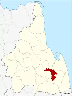 District location in Nakhon Si Thammarat Province | |
| Coordinates: 8°10′36″N 100°2′6″E | |
| Country | Thailand |
| Province | Nakhon Si Thammarat |
| Seat | Suan Luang |
| Area | |
| • Total | 124.1 km2 (47.9 sq mi) |
| Population (2005) | |
| • Total | 33,466 |
| • Density | 269.7/km2 (699/sq mi) |
| Time zone | UTC+7 (ICT) |
| Postal code | 80190 |
| Geocode | 8023 |
History
The district was created on 5 December 1996, together with four other districts named Chaloem Phra Kiat in celebration of the 50th anniversary of King Bhumibol Adulyadej's accession to the throne.
The district was composed of three tambons: Chian Khao, Don Tro, and Suan Luang of Chian Yai District and tambon Thang Phun from Ron Phibun.[1]
Geography
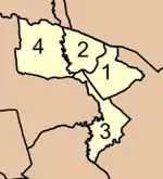
Neighboring districts are (from the north clockwise): Phra Phrom, Mueang Nakhon Si Thammarat, Pak Phanang, Chian Yai, Cha-uat, and Ron Phibun.
Administration
The district is divided into four sub-districts (tambons), which are further subdivided into 37 villages (mubans). There are no municipal (thesaban) areas, and four tambon administrative organizations (TAO).
|
 |
References
- พระราชกฤษฎีกาตั้งอำเภอเฉลิมพระเกียรติ จังหวัดนครราชสีมา อำเภอเฉลิมพระเกียรติ จังหวัดนครศรีธรรมราช อำเภอเฉลิมพระเกียรติ จังหวัดน่าน อำเภอเฉลิมพระเกียรติ จังหวัดบุรีรัมย์ และอำเภอเฉลิมพระเกียรติ จังหวัดสระบุรี พ.ศ. ๒๕๓๙ (PDF). Royal Gazette (in Thai). 113 (62 ก): 1–4. 20 November 1996.