Lan Saka District
Lan Saka (Thai: ลานสกา, pronounced [lāːn sā.kāː]) is a district (amphoe) of Nakhon Si Thammarat Province, southern Thailand.
Lan Saka
ลานสกา | |
|---|---|
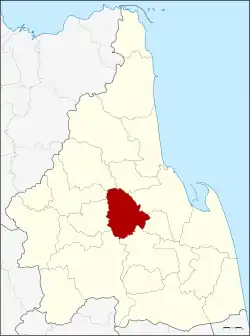 District location in Nakhon Si Thammarat Province | |
| Coordinates: 8°22′18″N 99°48′18″E | |
| Country | Thailand |
| Province | Nakhon Si Thammarat |
| Seat | Khao Kaeo |
| Area | |
| • Total | 342.90 km2 (132.39 sq mi) |
| Population (2012) | |
| • Total | 40,406 |
| • Density | 117.83/km2 (305.2/sq mi) |
| Time zone | UTC+7 (ICT) |
| Postal code | 80230 |
| Geocode | 8003 |
History
The district was at first a minor district (king amphoe) named Khao Kaeo (เขาแก้ว), which was a subordinate of Mueang Nakhon Si Thammarat District. When the district office was moved to tambon Lan Saka, the district was renamed accordingly. In 1958 it was upgraded to a full district.[1]
Geography
Neighboring districts are (from the north clockwise): Phrom Khiri, Mueang Nakhon Si Thammarat, Phra Phrom, Ron Phibun, Thung Song, Chang Klang, Chawang and Phipun.
Khao Luang National Park is in Lan Saka District.
Administration
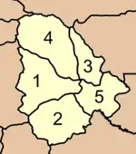
The district is divided into five sub-districts (tambons), which are further subdivided into 42 villages (mubans). Lan Saka is a township (thesaban tambon) which covers parts of tambon Khao Kaeo. There are a further five tambon administrative organizations.
|
 |
References
- lansaka.nakhoncdp.go.th Archived 2007-01-03 at the Wayback Machine