Chang Klang District
Chang Klang (Thai: ช้างกลาง, pronounced [t͡ɕʰáːŋ klāːŋ]) is a district (amphoe) of Nakhon Si Thammarat Province, southern Thailand.
Chang Klang
ช้างกลาง | |
|---|---|
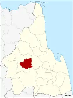 District location in Nakhon Si Thammarat Province | |
| Coordinates: 8°22′27″N 99°34′5″E | |
| Country | Thailand |
| Province | Nakhon Si Thammarat |
| Seat | Chang Klang |
| Area | |
| • Total | 232.5 km2 (89.8 sq mi) |
| Population (2005) | |
| • Total | 29,594 |
| • Density | 127.3/km2 (330/sq mi) |
| Time zone | UTC+7 (ICT) |
| Postal code | 80250 |
| Geocode | 8022 |
History
The district was created on 15 July 1996 by splitting the three southeastern tambons from Chawang District.[1]
On 15 May 2007, all 81 minor districts were upgraded to full districts.[2] On 24 August, the upgrade became official.[3]
Geography
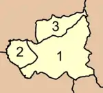
Neighboring districts are (from the north clockwise): Chawang, Lan Saka, Thung Song, and Na Bon.
Administration
The district is divided into three sub-districts (tambons), which are further subdivided into 35 villages (mubans). There are no municipal (thesaban) areas, and three tambon administrative organizations (TAO).
|
 |
References
- ประกาศกระทรวงมหาดไทย เรื่อง แบ่งเขตท้องที่อำเภอฉวาง จังหวัดนครศรีธรรมราช ตั้งเป็นกิ่งอำเภอช้างกลาง (PDF). Royal Gazette (in Thai). 113 (Special 18 ง): 32. 26 June 1996.
- แถลงผลการประชุม ครม. ประจำวันที่ 15 พ.ค. 2550 (in Thai). Manager Online.
- พระราชกฤษฎีกาตั้งอำเภอฆ้องชัย...และอำเภอเหล่าเสือโก้ก พ.ศ. ๒๕๕๐ (PDF). Royal Gazette (in Thai). 124 (46 ก): 14–21. 24 August 2007.
This article is issued from Wikipedia. The text is licensed under Creative Commons - Attribution - Sharealike. Additional terms may apply for the media files.