Na Bon District
Na Bon (Thai: นาบอน, pronounced [nāː bɔ̄ːn]) is a district (amphoe) of Nakhon Si Thammarat Province, southern Thailand.
Na Bon
นาบอน | |
|---|---|
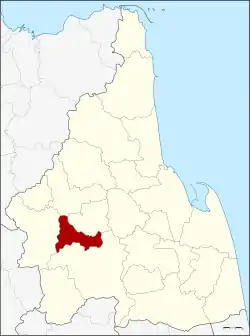 District location in Nakhon Si Thammarat Province | |
| Coordinates: 8°15′42″N 99°35′42″E | |
| Country | Thailand |
| Province | Nakhon Si Thammarat |
| Seat | Na Bon |
| Area | |
| • Total | 192.899 km2 (74.479 sq mi) |
| Population (2005) | |
| • Total | 26,428 |
| • Density | 137.0/km2 (355/sq mi) |
| Time zone | UTC+7 (ICT) |
| Postal code | 80220 |
| Geocode | 8010 |
Geography
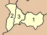
Neighboring districts are (from the north clockwise): Chawang, Chang Klang, Thung Song, and Thung Yai.
Namtok Yong National Park is at the boundary to Thung Song District, protecting forested hills of the Nakhon Si Thammarat Range and includes several waterfalls.
History
On 9 June 1975 the two tambons, Na Bon and Thung Song, were split from Thung Song District to form the new minor district (king amphoe) Na Bon.[1] On 13 July 1981 it was upgraded to a full district.[2][3]
Symbols
The slogan of the district is "Khlong Chang waterfall, good breed of rubber, fertile land, join pit krit festival".
Administration
The district is divided into three sub-districts (tambons), which are further subdivided into 34 villages (mubans). Na Bon is a township (thesaban tambon) which covers parts of tambon Na Bon. There are a further three tambon administrative organizations (TAO).
|
 |
References
- ประกาศกระทรวงมหาดไทย เรื่อง แบ่งท้องที่อำเภอทุ่งสง จังหวัดนครศรีธรรมราช ตั้งเป็นกิ่งอำเภอนาบอน (PDF). Royal Gazette (in Thai). 92 (104 ง): 1339. June 3, 1975.
- พระราชกฤษฎีกาตั้งอำเภอหนองใหญ่ อำเภอบ่อไร่ อำเภอพรหมคีรี อำเภอนาบอน อำเภอบางสะพานน้อย อำเภอนาดี อำเภอกงหรา อำเภอวังทรายพูน อำเภอธารโต อำเภอคำตากล้า อำเภอศรีนคร อำเภอด่านช้าง อำเภอพรเจริญ อำเภอวังสามหมอ และอำเภอลานสัก พ.ศ. ๒๕๒๔ (PDF). Royal Gazette (in Thai). 98 (115 ก Special): 7–10. July 13, 1981.
- Nakhon Si Thammarat Rajabhat University
External links
- amphoe.com
- https://web.archive.org/web/20170611200442/http://www.naboncity.go.th/ Website of Na Bon township (Thai)