Phipun District
Phipun (Thai: พิปูน, pronounced [pʰí.pūːn]) is a district (amphoe) in the northern part of Nakhon Si Thammarat Province, southern Thailand.
Phipun
พิปูน | |
|---|---|
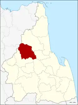 District location in Nakhon Si Thammarat Province | |
| Coordinates: 8°33′36″N 99°36′30″E | |
| Country | Thailand |
| Province | Nakhon Si Thammarat |
| Seat | Phipun |
| Area | |
| • Total | 363.8 km2 (140.5 sq mi) |
| Population (2005) | |
| • Total | 27,578 |
| • Density | 75.8/km2 (196/sq mi) |
| Time zone | UTC+7 (ICT) |
| Postal code | 80270 |
| Geocode | 8005 |
Geography
Neighboring districts are (from the northeast clockwise): Nopphitam, Phrom Khiri, Lan Saka, and Chawang of Nakhon Si Thammarat Province; Wiang Sa and Ban Na San of Surat Thani Province.
History
The minor district (king amphoe) was created on 1 September 1972, when the two tambons Phipun and Kathun were split off from Chawang District.[1] It was upgraded to a full district on 8 September 1976.[2]
Administration
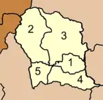
The district is divided into five sub-districts (tambons), which are further subdivided into 43 villages (mubans). Phibun is a township (thesaban tambon) covering parts of tambon Phibun. There are a further five tambon administrative organizations (TAO).
|
 |
References
- ประกาศกระทรวงมหาดไทย เรื่อง แบ่งท้องที่อำเภอฉวาง จังหวัดนครศรีธรรมราช ตั้งเป็นกิ่งอำเภอพิปูน (PDF). Royal Gazette (in Thai). 89 (130 ง): 2187. August 29, 1972.
- พระราชกฤษฎีกาตั้งอำเภอเลาขวัญ อำเภอคำม่วง อำเภอพิปูน อำเภอศรีเทพ อำเภอนาแห้ว อำเภอส่องดาว อำเภอควนกาหลง อำเภอค่ายบางระจัน อำเภอบ้านตาขุน และอำเภอกุดจับ พ.ศ. ๒๕๑๙ (PDF). Royal Gazette (in Thai). 93 (109 ก special): 31–34. September 8, 1976.