Chamberlain, South Dakota
Chamberlain (Lakota: makȟáthipi;[7] "earth dwelling") is a city in Brule County, South Dakota, United States. It is located on the eastern bank of the Lake Francis Case dammed section of the Missouri River, close to where it is crossed by Interstate 90.
Chamberlain, South Dakota
Makȟáthipi | |
|---|---|
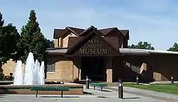 Akta Lakota Museum, 2003 | |
| Motto(s): "One day just isn't enough..." | |
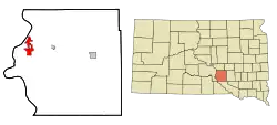 Location in Brule County and the state of South Dakota | |
| Coordinates: 43°48′20″N 99°19′42″W | |
| Country | United States |
| State | South Dakota |
| County | Brule |
| Founded | 1881[1] |
| Area | |
| • Total | 5.67 sq mi (14.70 km2) |
| • Land | 4.48 sq mi (11.60 km2) |
| • Water | 1.20 sq mi (3.10 km2) |
| Elevation | 1,404 ft (428 m) |
| Population | |
| • Total | 2,387 |
| • Estimate (2019)[4] | 2,366 |
| • Density | 528.24/sq mi (203.94/km2) |
| Time zone | UTC−6 (Central (CST)) |
| • Summer (DST) | UTC−5 (CDT) |
| ZIP codes | 57325-57326 |
| Area code(s) | 605 |
| FIPS code | 46-11220[5] |
| GNIS feature ID | 1265153[6] |
| Website | www |
The population of Chamberlain was 2,387 at the 2010 census. It is the county seat of Brule County.[8]
Chamberlain is home to the South Dakota Hall of Fame, and St. Joseph's Indian School, a Native American residential school run by the Catholic Priests of the Sacred Heart. The 50-foot (15 m) sculpture of a Native American woman, Dignity, overlooks the Missouri River on a bluff outside the city.
History
Chamberlain was named after Selah Chamberlain, a railroad director of the Chicago, Milwaukee and St. Paul Railway.[9][10]
Geography
Chamberlain is located at 43°49′20″N 99°19′42″W (43.805548, -99.328444).[11]
According to the United States Census Bureau, the city has a total area of 7.84 square miles (20.31 km2), of which 6.64 square miles (17.20 km2) is land and 1.20 square miles (3.11 km2) is water.[12]
Chamberlain has been assigned the ZIP code range 57325-57326 and the FIPS place code 11220.
Demographics
| Historical population | |||
|---|---|---|---|
| Census | Pop. | %± | |
| 1890 | 939 | — | |
| 1900 | 874 | −6.9% | |
| 1910 | 1,275 | 45.9% | |
| 1920 | 1,303 | 2.2% | |
| 1930 | 1,364 | 4.7% | |
| 1940 | 1,626 | 19.2% | |
| 1950 | 1,912 | 17.6% | |
| 1960 | 2,598 | 35.9% | |
| 1970 | 2,626 | 1.1% | |
| 1980 | 2,258 | −14.0% | |
| 1990 | 2,347 | 3.9% | |
| 2000 | 2,338 | −0.4% | |
| 2010 | 2,387 | 2.1% | |
| 2019 (est.) | 2,366 | [4] | −0.9% |
| U.S. Decennial Census | |||
2010 census
As of the census[3] of 2010, there were 2,387 people, 1,040 households, and 589 families living in the city. The population density was 359.5 inhabitants per square mile (138.8/km2). There were 1,142 housing units at an average density of 172.0 per square mile (66.4/km2). The racial makeup of the city was 81.9% White, 0.3% African American, 14.8% Native American, 0.2% Asian, 0.1% from other races, and 2.8% from two or more races. Hispanic or Latino of any race were 1.5% of the population.
There were 1,040 households, of which 28.1% had children under the age of 18 living with them, 41.1% were married couples living together, 12.9% had a female householder with no husband present, 2.7% had a male householder with no wife present, and 43.4% were non-families. 36.9% of all households were made up of individuals, and 15% had someone living alone who was 65 years of age or older. The average household size was 2.17 and the average family size was 2.87.
The median age in the city was 41.8 years. 24.1% of residents were under the age of 18; 6.9% were between the ages of 18 and 24; 22.7% were from 25 to 44; 28.7% were from 45 to 64; and 17.6% were 65 years of age or older. The gender makeup of the city was 45.7% male and 54.3% female.
2000 census
As of the census[5] of 2000, there were 2,338 people, 942 households, and 550 families living in the city. The population density was 360.8 people per square mile (139.3/km2). There were 1,044 housing units at an average density of 161.1 per square mile (62.2/km2). The racial makeup of the city was 86.83% White, 0.60% African American, 10.18% Native American, 0.38% Asian, 0.04% Pacific Islander, 0.13% from other races, and 1.84% from two or more races. Hispanic or Latino of any race were 0.68% of the population.
There were 942 households, out of which 29.0% had children under the age of 18 living with them, 45.3% were married couples living together, 10.0% had a female householder with no husband present, and 41.6% were non-families. 36.2% of all households were made up of individuals, and 15.2% had someone living alone who was 65 years of age or older. The average household size was 2.27 and the average family size was 3.01.
In the city the population was spread out, with 26.9% under the age of 18, 6.8% from 18 to 24, 27.2% from 25 to 44, 21.5% from 45 to 64, and 17.5% who were 65 years of age or older. The median age was 38 years. For every 100 females, there were 86.0 males. For every 100 females age 18 and over, there were 82.6 males.
As of 2000 the median income for a household in the city was $34,487, and the median income for a family was $43,500. Males had a median income of $29,545 versus $22,009 for females. The per capita income for the city was $17,018. About 4.4% of families and 12.0% of the population were below the poverty line, including 3.9% of those under age 18 and 25.9% of those age 65 or over.
Transportation
Chamberlain is served by the Chamberlain Municipal Airport, as well as the following three highways:
See also
References
- "SD Towns" (PDF). South Dakota State Historical Society. Archived from the original (PDF) on 2010-02-10. Retrieved 2010-02-11.
- "2019 U.S. Gazetteer Files". United States Census Bureau. Retrieved July 30, 2020.
- "U.S. Census website". United States Census Bureau. Retrieved 2012-06-21.
- "Population and Housing Unit Estimates". United States Census Bureau. May 24, 2020. Retrieved May 27, 2020.
- "U.S. Census website". United States Census Bureau. Retrieved 2008-01-31.
- "US Board on Geographic Names". United States Geological Survey. 2007-10-25. Retrieved 2008-01-31.
- Ullrich, Jan F. (2014). New Lakota Dictionary (2nd ed.). Bloomington, IN: Lakota Language Consortium. ISBN 978-0-9761082-9-0. Archived from the original on 2016-10-18. Retrieved 2014-02-13.
- "Find a County". National Association of Counties. Retrieved 2011-06-07.
- "Profile for Chamberlain, South Dakota". ePodunk. Retrieved 2010-05-29.
- Gannett, Henry (1905). The Origin of Certain Place Names in the United States. Govt. Print. Off. pp. 74.
- "US Gazetteer files: 2010, 2000, and 1990". United States Census Bureau. 2011-02-12. Retrieved 2011-04-23.
- "US Gazetteer files 2010". United States Census Bureau. Archived from the original on 2012-07-02. Retrieved 2012-06-21.
External links
| Wikimedia Commons has media related to Chamberlain, South Dakota. |
Municipalities and communities of Brule County, South Dakota, United States | ||
|---|---|---|
| Cities | 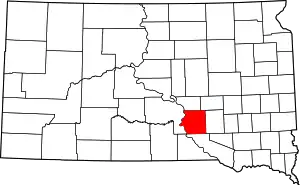 | |
| Town | ||
| CDPs | ||
| Unincorporated community | ||
| Townships |
| |
| Unorganized Territory |
| |
| ||