Ola, South Dakota
Ola is an unincorporated community and census-designated place in Brule County, South Dakota, United States. The population was 13 according to the 2010 census.[1]
Ola, South Dakota | |
|---|---|
 Ola Location within the state of South Dakota | |
| Coordinates: 43°36′02″N 99°12′38″W | |
| Country | United States |
| State | South Dakota |
| Counties | Brule |
| Area | |
| • Total | 4.0 sq mi (10.4 km2) |
| • Land | 4.0 sq mi (10.4 km2) |
| • Water | 0.0 sq mi (0.0 km2) |
| Elevation | 1,735 ft (529 m) |
| Population (2010) | |
| • Total | 13 |
| • Density | 3/sq mi (1.2/km2) |
| Time zone | UTC-6 (Central (CST)) |
| • Summer (DST) | UTC-5 (CDT) |
| FIPS code | 46-46700 |
| GNIS feature ID | 1261051 |
The CDP is located in southern Brule County, 2 miles (3 km) west of South Dakota Highway 50 and 12 miles (19 km) south of Interstate 90.
References
- "Geographic Identifiers: 2010 Demographic Profile Data (G001): Ola CDP, South Dakota". U.S. Census Bureau, American Factfinder. Archived from the original on February 12, 2020. Retrieved April 8, 2014.
Municipalities and communities of Brule County, South Dakota, United States | ||
|---|---|---|
| Cities | 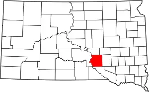 | |
| Town | ||
| CDPs | ||
| Unincorporated community | ||
| Townships |
| |
| Unorganized Territory |
| |
| ||
This article is issued from Wikipedia. The text is licensed under Creative Commons - Attribution - Sharealike. Additional terms may apply for the media files.