Chetamon Mountain
Chetamon Mountain is a 2,606-metre (8,550-foot) mountain summit located in Jasper National Park, in the De Smet Range of the Canadian Rockies in Alberta, Canada. The peak is situated 18 kilometres (11 mi) north of the municipality of Jasper, in the Athabasca Valley and is visible from Highway 16 and the Canadian. Its nearest higher peak is Cliff Mountain, 3.5 km (2.2 mi) to the northwest.[1]
| Chetamon Mountain | |
|---|---|
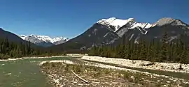 Chetamon Mountain and Snaring River seen from Highway 16 | |
| Highest point | |
| Elevation | 2,606 m (8,550 ft) [1]> |
| Prominence | 122 m (400 ft) [1] |
| Listing | Mountains of Alberta |
| Coordinates | 53°03′07″N 118°11′57″W [2] |
| Geography | |
 Chetamon Mountain Location of Chetamon Mountain in Alberta  Chetamon Mountain Chetamon Mountain (Canada) | |
| Location | Jasper National Park Alberta, Canada |
| Parent range | De Smet Range[3] Canadian Rockies |
| Topo map | NTS 83E/01[2] |
| Geology | |
| Type of rock | sedimentary rock |

Chetamon Mountain is a name derived from the Stoney language meaning "squirrel".[4] The mountain was named in 1916 by Morrison P. Bridgland because two rocks on the peak's arête had the appearance a squirrel.[1] Bridgland (1878-1948) was a Dominion Land Surveyor who named many peaks in Jasper Park and the Canadian Rockies.[5] The mountain's name was officially adopted in 1956 by the Geographical Names Board of Canada.[2]
Climate
Based on the Köppen climate classification, Chetamon Mountain is located in a subarctic climate with cold, snowy winters, and mild summers.[6] Temperatures can drop below -20 °C with wind chill factors below -30 °C. In terms of favorable weather, June through September are the best months to climb. Precipitation runoff from Chetamon Mountain flows into the Athabasca River via the Snaring River and Cobblestone Creek.
See also
References
- "Chetamon Mountain". Bivouac.com. Retrieved 2019-03-13.
- "Chetamon Mountain". Geographical Names Data Base. Natural Resources Canada. Retrieved 2019-02-28.
- "Chetamon". Peakbagger.com. Retrieved 2021-01-05.
- Place-names of Alberta. Ottawa: Geographic Board of Canada. 1928. p. 33.
- Mapper of Mountains M.P. Bridgland in the Canadian Rockies 1902-1930, Author I.S. MacLaren, The University of Alberta Press, ISBN 0-88864-456-6
- Peel, M. C.; Finlayson, B. L. & McMahon, T. A. (2007). "Updated world map of the Köppen−Geiger climate classification". Hydrol. Earth Syst. Sci. 11: 1633–1644. ISSN 1027-5606.
External links
- Parks Canada web site: Jasper National Park