High Rock Range
High Rock Range is a mountain range of the Canadian Rockies in southwestern Alberta and southeastern British Columbia, Canada.
| High Rock Range | |
|---|---|
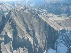 Mount Rae from the north, Sept. 2006 | |
| Highest point | |
| Peak | Mount Rae |
| Elevation | 3,218 m (10,558 ft) |
| Coordinates | 50°37′20″N 114°58′25″W |
| Dimensions | |
| Length | 117 km (73 mi) N-S [1] |
| Width | 37 km (23 mi) E-W [1] |
| Area | 2,172 km2 (839 sq mi) |
| Geography | |
 High Rock Range Location of High Rock Range on the Continental Divide | |
| Country | Canada |
| Provinces | Alberta and British Columbia |
| Parent range | Canadian Rockies |
It is a part of the Southern Continental Ranges and is located on the Continental Divide, north of the Crowsnest Pass and south of the Highwood Pass.[2] It lies partly within Kananaskis Country.
Misty Range and Greenhills Range are subdivisions of the High Rock.
The High Rock Range covers a surface of 2,172 km2 (838 mi2), has a length of 117 km (73 mi) (from north to south) and a width of 37 km (23 mi).[1]
Peaks and mountains
- Mount Rae - 3,218 m (10,558 ft)
- Mist Mountain - 3,140 m (10,302 ft)
- Tornado Mountain - 3,099 m (10,167 ft)
- Courcelette Peak - 3,044 m (9,987 ft)
- Mount Lyall - 2,951 m (9,682 ft)
- Beehive Mountain - 2,895 m (9,498 ft)
- Mount Armstrong - 2,793 m (9,163 ft)
- Mount Muir - 2,758 m (9,049 ft)
- Allison Peak - 2,646 m (8,681 ft)
See also
References
- "High Rock Range". Peakbagger.com. Retrieved 2006-09-20.
- "High Rock Range". PeakFinder.com. Retrieved 2006-09-20.
This article is issued from Wikipedia. The text is licensed under Creative Commons - Attribution - Sharealike. Additional terms may apply for the media files.