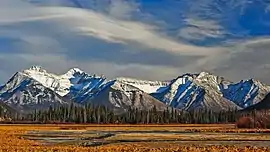
Fairholme Range
The Fairholme Range is a mountain range east of the Bow River valley in the Canadian Rockies. The range is bounded on the west side by the Trans-Canada Highway as it passes through the towns of Exshaw and Canmore, while the northern section of the range extends into Banff National Park to the southern shores of Lake Minnewanka.[4] John Palliser named the range in 1859 after his sister Grace Fairholme, who had married William Fairholme.[5]
| Fairholme Range | |
|---|---|
 | |
| Highest point | |
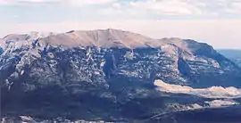
| Peak | Mount Girouard |
| Elevation | 2,995 m (9,826 ft) [1] |
| Coordinates | 51°14′10″N 115°24′11″W [2] |
| Geography | |
 | |
| Country | Canada |
| Province | Alberta |
| Range coordinates | 51°08′59″N 115°19′36″W [3] |
| Parent range | Front Ranges |
Peaks of this range include:
| Mountain/Peak | metres | feet |
|---|---|---|
| Mount Girouard | 2,995 | 9,827 |
| Mount Inglismaldie | 2,964 | 9,725 |
| Mount Peechee | 2,935 | 9,630 |
| Mount Charles Stewart | 2,809 | 9,216 |
| Grotto Mountain | 2,706 | 8,878 |
| Mount Lady Macdonald | 2,606 | 8,550 |
| Princess Margaret Mountain | 2,515 | 8,252 |
| Squaw's Tit | 2,514 | 8,250 |
After similar rumours over the years, on August 20, 2020 it was reported that "Squaw's Tit" (see last in table above) would be renamed to avoid racist and misogynistic naming. Talks with Stoney Nakoda are ongoing to find a culturally appropriate name and a request to support the initiative will be brought to the Municipal District of Bighorn later this month (Sep 2020).[6]
In the spring and summer of 2003, Parks Canada performed a prescribed burn in selected areas of the range in order to reduce fire hazard, manage pine beetle population and increase sheep habitat. In total, 5300 hectares of land were affected.[7]
Further reading
- Brian Patton, Bart Robinson, Canadian Rockies Trail Guide, PP 16, 32
- Brian Patton, Parkways of the Canadian Rockies: A Touring Guide to Banff, Jasper, Kootenay, PP 13 - 14, 41
References
- "Mount Girouard". PeakFinder.com. Retrieved 2019-08-02.
- "Mount Girouard". Geographical Names Data Base. Natural Resources Canada. Retrieved 2019-08-02.
- "Fairholme Range". Geographical Names Data Base. Natural Resources Canada. Retrieved 2019-08-02.
- Ommanney, Simon (2002). Williams, Jr., Richard; Ferrigno, Jane (eds.). "Glaciers of the Canadian Rockies" (PDF). U.S. Geological Survey Professional Paper 1386: Satellite Image Atlas of the Glaciers of the World -- North America. Washington, D.C.: USGS: 224. Retrieved 2019-08-02.
- "Fairholme Range". PeakFinder.com. Retrieved 2004-06-15.
- name=RMOToday>Dulewich, Jenna (2020-08-20). "Moving Mountains: How Bow Valley is taking a stand against a peak with a racist name". Canmore, AB. Retrieved 2020-08-20.
- "2003 Prescribed burn in the Fairholme Range". Parks Canada. Archived from the original on 2011-07-06. Retrieved 2005-10-16.