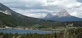
Crowsnest Pass, Alberta
The Municipality of Crowsnest Pass is a specialized municipality located in the Crowsnest Pass of the Rocky Mountains in southwest Alberta, Canada. The municipality formed as a result of the amalgamation of five municipalities (the Village of Bellevue; the Town of Blairmore; Town of Coleman; the Village of Frank and Improvement District No. 5, which included the Hamlet of Hillcrest) on January 1, 1979. Today, Blairmore and Coleman remain the two largest communities while Frank is the smallest. Crowsnest, Passburg, and Sentinel (Sentry Siding[3]) are other former communities (abandoned, or much reduced) within the municipality's boundaries.
Crowsnest Pass | |
|---|---|
| Municipality of Crowsnest Pass | |
 | |
| Motto(s): Naturally Rewarding | |
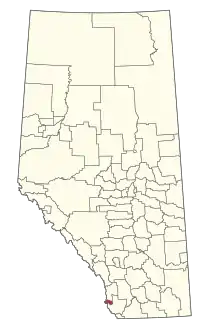 Location within Alberta | |
| Coordinates: 49°37′30″N 114°28′5″W | |
| Country | |
| Province | |
| Region | Southern Alberta |
| Census division | 15 |
| - Town | January 1, 1979 |
| - Specialized municipality | January 16, 2008 |
| Government | |
| • Mayor | Blair Painter |
| • Governing body | Crowsnest Pass Municipal Council |
| • CAO | Patrick Thomas (acting) |
| • MP | John Barlow |
| • MLA | Pat Stier |
| Area (2016)[2] | |
| • Land | 371.44 km2 (143.41 sq mi) |
| Elevation | 1,310 m (4,300 ft) |
| Population (2016)[2] | |
| • Total | 5,589 |
| • Density | 15/km2 (40/sq mi) |
| Time zone | UTC−7 (MST) |
| • Summer (DST) | UTC−6 (MDT) |
| Postal code span | T0K 0E0, 0M0, 0C0, 1C0 |
| Area code(s) | 403 / 587 |
| Highways | |
| Website | Official website |
History
The municipality owes its existence to coal mining, the area's primary industry since the first mine opened in 1900. Its ethnic and cultural diversity comes from the many European and other immigrants attracted to the area by the mines. Through the years' coal mining suffered from fluctuating coal prices, bitter strikes, and underground accidents, and all the mines on the Alberta side closed throughout the 20th century as cheaper, safer open-pit mines opened on the British Columbia side of the pass. There is an operating coal mine just across the BC border in Sparwood, which continues to provide significant employment for the Municipality of Crowsnest Pass.
Crowsnest Pass is known for tragedy. In 1903, the tip of Turtle Mountain broke loose and decimated part of the Village of Frank (the Frank Slide). In 1914, the Hillcrest mine disaster occurred in the Hillcrest Mine, killing 189 men. Serious spring floods occurred in 1923 and 1942. Periodic forest fires have swept the valley, including one in the summer of 2003 that threatened the entire municipality.
The area was a centre for "rum-running" during prohibition, from 1916 to 1923, when liquor was illegally brought across the provincial border from British Columbia. The legacy is celebrated at the restored Alberta Provincial Police Barracks, now an interpretive centre.
For more detailed area history, see the entries for Coleman, Blairmore, Frank, Hillcrest and Bellevue.
Communities and localities
The following communities are the former municipalities that comprise the Municipality of Crowsnest Pass:[4]
- Former towns
- Former villages
- Former improvement districts
- Improvement District No. 5 (part)
- Improvement District No. 6 (part)
The following localities are located within the Municipality of Crowsnest Pass:[5]
- Localities
- Crowsnest
- East Kootenay
- Hazell
- Hillcrest or Hillcrest Mines
- Savanna
- Sentinel
Demographics
| Year | Pop. | ±% |
|---|---|---|
| 1976 | 7,286 | — |
| 1981 | 7,306 | +0.3% |
| 1986 | 6,912 | −5.4% |
| 1991 | 6,679 | −3.4% |
| 1996 | 6,356 | −4.8% |
| 2001 | 6,262 | −1.5% |
| 2006 | 5,749 | −8.2% |
| 2011 | 5,565 | −3.2% |
| 2016 | 5,589 | +0.4% |
| [6][7][8][9][10][11][12][2] | ||
In the 2016 Census of Population conducted by Statistics Canada, the Municipality of Crowsnest Pass recorded a population of 5,589 living in 2,567 of its 3,225 total private dwellings, a change of 0.4% from its 2011 population of 5,565. With a land area of 371.44 km2 (143.41 sq mi), it had a population density of 15.0/km2 (39.0/sq mi) in 2016.[2]
In the 2011 Census, the Municipality of Crowsnest Pass had a population of 5,565 living in 2,586 of its 3,234 total dwellings, a change of -3.2% from its 2006 population of 5,749. With a land area of 373.07 km2 (144.04 sq mi), it had a population density of 14.9/km2 (38.6/sq mi) in 2011.[12]
Attractions
Within the Municipality of Crowsnest Pass, one can find the Frank Slide Interpretive Centre (Provincial Historic Site), an interpretive display at Leitch Collieries (Provincial Historic Site), underground tours of the Bellevue Mine (Provincial Historic Resource), interpretive signs at the Hillcrest Cemetery (Provincial Historic Resource) and both the Crowsnest Museum and Alberta Provincial Police Barracks interpretive centre within Coleman National Historic Site. Pamphlets for self-guided historical walking and driving tours are available throughout the municipality.
The area offers hiking, fishing and mountain-biking in the summer, and in winter snowmobiling, a downhill ski hill (Pass PowderKeg), and a groomed cross-country ski area, and is about 70 kilometres (43 mi) from major ski hills at both Fernie Alpine Resort and Castle Mountain Resort.
Trivia
- Blairmore elected Canada's first Communist town council under mayor Bill Knight during the Great Depression.[13][14] (See Blairmore, Alberta for more information)
- Crowsnest Pass was the site of a train robbery in 1920.
- Alberta's first female mayor, Clemence Jepson (1914-2010), was elected in Bellevue in November 1963.
- The gravy recipe for Colonel Sanders' Kentucky Fried Chicken was developed here.[15]
- The frontier town in Disney's 1985 film The Journey of Natty Gann was shot here.
References
- "Municipal Officials Search". Alberta Municipal Affairs. September 22, 2017. Retrieved September 25, 2017.
- "Population and dwelling counts, for Canada, provinces and territories, and census subdivisions (municipalities), 2016 and 2011 censuses – 100% data (Alberta)". Statistics Canada. February 8, 2017. Retrieved February 8, 2017.
- Crowsnest Pass Historical Society (1979). Crowsnest and its people. Coleman: Crowsnest Pass Historical Society. p. 241. ISBN 0-88925-046-4.
- "2011 Municipal Affairs Population List" (PDF). Alberta Municipal Affairs. 2012-10-05. ISBN 978-0-7785-9738-4. Retrieved 2012-08-18.
- "Standard Geographical Classification (SGC) 2006, Economic Regions: 4815007 - Crowsnest Pass, geographical codes and localities, 2006". Statistics Canada. 2010-03-05. Archived from the original on 2013-05-25. Retrieved 2012-08-18.
- "Table 4: Population and Total Occupied Dwellings, for Census Divisions and Subdivisions, 1976 and 1981". 1981 Census of Canada. Volume II: Provincial series, Population, Geographic distributions (Alberta). Ottawa: Statistics Canada. 1982. p. 4.1–4.10. ISBN 0-660-51095-2.
- "Table 2: Census Divisions and Subdivisions – Population and Occupied Private Dwellings, 1981 and 1986". Census Canada 1986. Population and Dwelling Counts – Provinces and Territories (Alberta). Ottawa: Statistics Canada. 1987. p. 2.1–2.10. ISBN 0-660-53463-0.
- "Table 2: Population and Dwelling Counts, for Census Divisions and Census Subdivisions, 1986 and 1991 – 100% Data". 91 Census. Population and Dwelling Counts – Census Divisions and Census Subdivisions. Ottawa: Statistics Canada. 1992. pp. 100–108. ISBN 0-660-57115-3.
- "Table 10: Population and Dwelling Counts, for Census Divisions, Census Subdivisions (Municipalities) and Designated Places, 1991 and 1996 Censuses – 100% Data". 96 Census. A National Overview – Population and Dwelling Counts. Ottawa: Statistics Canada. 1997. pp. 136–146. ISBN 0-660-59283-5.
- "Population and Dwelling Counts, for Canada, Provinces and Territories, and Census Divisions, 2001 and 1996 Censuses - 100% Data (Alberta)". Statistics Canada. Retrieved 2013-02-16.
- "Population and dwelling counts, for Canada, provinces and territories, and census subdivisions (municipalities), 2006 and 2001 censuses - 100% data (Alberta)". Statistics Canada. 2010-01-06. Retrieved 2013-02-16.
- "Population and dwelling counts, for Canada, provinces and territories, and census subdivisions (municipalities), 2011 and 2006 censuses (Alberta)". Statistics Canada. 2012-02-08. Retrieved 2012-02-08.
- CBC article - Blairmore elections
- Blairmore the Red - Crowsnest Pass Promoter, Nov. 9 2007
- Crowsnest And Its People, Crowsnest Pass Historical Society, 1979
External links
| Wikimedia Commons has media related to Crowsnest Pass, Alberta. |
Places adjacent to Crowsnest Pass, Alberta | ||||||||||
|---|---|---|---|---|---|---|---|---|---|---|
| ||||||||||