City of Onkaparinga
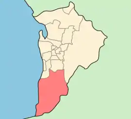
The City of Onkaparinga (/ˌɒŋkəpəˈrɪŋɡə/) is a local government area (LGA) located on the southern fringe of Adelaide, South Australia. It is named after the Onkaparinga River, whose name comes from Ngangkiparinga, a Kaurna word meaning women's river. It is the largest LGA in South Australia, with a population of over 170,000 people in both urban and rural communities and is also geographically expansive, encompassing an area of 518.3 km². The council is headquartered in the Noarlunga Centre with area offices situated in Aberfoyle Park, Woodcroft and Willunga.
| City of Onkaparinga South Australia | |||||||||||||||
|---|---|---|---|---|---|---|---|---|---|---|---|---|---|---|---|
 | |||||||||||||||
| Population |
| ||||||||||||||
| • Density | 321.69/km2 (833.18/sq mi) | ||||||||||||||
| Established | 6 March 1997[3] | ||||||||||||||
| Area | 518.4 km2 (200.2 sq mi) | ||||||||||||||
| Mayor | Erin Thompson [4] | ||||||||||||||
| Council seat | Noarlunga Centre | ||||||||||||||
| Region | Southern Adelaide[5] | ||||||||||||||
| County | Adelaide[6] | ||||||||||||||
| State electorate(s) | Davenport, Finniss, Fisher, Heysen, Kaurna, Mawson, Mitchell, Reynell | ||||||||||||||
| Federal Division(s) | Kingston, Mayo | ||||||||||||||
 | |||||||||||||||
| Website | City of Onkaparinga | ||||||||||||||
| |||||||||||||||
History
The council was formed on 1 July 1997 as the City of Happy Valley, Noarlunga and Willunga from the amalgamation of the former City of Happy Valley and City of Noarlunga with part of the District Council of Willunga.[7] It adopted the City of Onkaparinga name from 22 December 1997.[8]
Demographics
| Selected historical census data for Onkaparinga local government area | ||||||
|---|---|---|---|---|---|---|
| Census year | 2001[9] | 2006[10] | 2011[11] | 2016[1] | ||
| Population | Estimated residents on census night | 143,143 | 144,407 | 159,576 | 166,766 | |
| LGA rank in terms of size within South Australia | 1st | |||||
| % of South Australia population | 9.81% | |||||
| % of Australian population | 0.76% | |||||
| Cultural and language diversity | ||||||
| Ancestry, top responses | English | 35.4% | ||||
| Australian | 28.9% | |||||
| Scottish | 6.8% | |||||
| Irish | 5.8% | |||||
| German | 5.3% | |||||
| Language, top responses (other than English) | Polish | 0.7% | ||||
| German | 0.7% | |||||
| Italian | 0.6% | |||||
| Greek | 0.5% | |||||
| Dutch | 0.43% | |||||
| Arabic | 0.3% | |||||
| Mandarin | 0.5% | |||||
| Religious affiliation | ||||||
| Religious affiliation, top responses | No religion | 25.5% | ||||
| Anglican | 17.6% | |||||
| Catholic | 16.2% | |||||
| Uniting | 10.3% | |||||
| Lutheran | 3.1% | |||||
| Median weekly incomes | ||||||
| Personal income | Median weekly personal income | A$439 | A$542 | A$593 | ||
| % of Australian median income | 98.4% | 93.9% | 95.3% | |||
| Family income | Median weekly family income | A$1088 | A$1311 | A$1448 | ||
| % of Australian median income | 92.9% | 88.5% | 83.5% | |||
| Household income | Median weekly household income | A$922 | A$1080 | A$1194 | ||
| % of Australian median income | 89.8% | 87.5% | 83.0% | |||
Governance
The council meets at the chambers in Noarlunga Centre on Hannah Road every four weeks on a Tuesday for Council meeting, and on the alternate Tuesday for Strategic Directions Meetings.
The City of Onkaparinga has 13 elected members (including the mayor). The city is divided into six electoral wards, with two councillors representing each. The mayor is elected at large by all electors.
The current council was elected in 2018 for a four-year term.[12]
| Ward | Party[13] | Councillor | Notes | |
|---|---|---|---|---|
| Mayor | Independent | Erin Thompson | ||
| Knox | Cr Alayna de Graaf | |||
| Liberal | Cr Heidi Greaves | |||
| Mid Coast | Labor | Cr Bill Jamieson | ||
| Cr Suzanne Tonkin | ||||
| Pimpala | Independent | Cr Sandra Brown | ||
| Cr Michael O'Brien | ||||
| South Coast | Liberal | Cr Simon McMahon | ||
| Cr Richard Peat | ||||
| Southern Vales Coast | Cr Martin Bray | |||
| Independent | Cr Wayne Olsen | |||
| Thalassa | Cr Geoff Eaton | |||
| Liberal | Cr Marion Themeliotis | |||
Suburbs
- Aberfoyle Park - 5159
- Aldinga - 5173
- Aldinga Beach – 5173
- Blewitt Springs - 5171
- Chandlers Hill - 5159
- Cherry Gardens - 5157
- Christie Downs - 5164
- Christies Beach - 5165
- Clarendon – 5157
- Coromandel East - 5157
- Coromandel Valley - 5051
- Darlington - 5047
- Dorset Vale - 5157
- Flagstaff Hill - 5159
- Hackham - 5163
- Hackham West - 5163
- Happy Valley - 5159
- Huntfield Heights - 5163
- Ironbank - 5153
- Kangarilla - 5157
- Lonsdale - 5160
- Maslin Beach - 5170
- McLaren Flat - 5171
- McLaren Vale - 5171
- Moana - 5169
- Morphett Vale – 5162
- Noarlunga Centre - 5168
- Noarlunga Downs - 5168
- O'Halloran Hill - 5158
- O'Sullivan Beach - 5166
- Old Noarlunga - 5168
- Old Reynella - 5161
- Onkaparinga Hills - 5163
- Port Noarlunga – 5167
- Port Noarlunga South - 5167
- Port Willunga - 5173
- Reynella - 5161
- Reynella East - 5161
- Seaford - 5169
- Seaford Heights - 5169
- Seaford Meadows - 5169
- Seaford Rise - 5169
- Sellicks Beach - 5174
- Sellicks Hill - 5174
- Tatachilla - 5171
- The Range - 5172
- Whites Valley - 5172
- Willunga - 5172
- Willunga South - 5172
- Woodcroft – 5162
That is, postcodes 5047, 5051, 5153, and 5157–74 (inclusive).[14]
Freedom of the City
The Freedom of the City is reserved for military units which have, through their command, a significant attachment to the City of Onkaparinga. Freedom of the City is the highest honour the City can confer on a military unit.[15]
Recipients
Three military units have been awarded Freedom of the City:
- 1998 - 40th Regional Cadet Unit Noarlunga
- 2004 - Squadron 605 Australian Air Force Cadets and Australian Navy Cadets TS Noarlunga
- 2016 - 619 Squadron, Australian Air Force Cadets
Key to the City
The Key to the City recognises exceptional, outstanding achievement and is Council’s most prestigious award. The award acknowledges the outstanding contribution of an individual or organisation in furthering the ideals of the city or to recognise outstanding achievement.[16]
Recipients
- 1998 - Dr Andrew "Andy" Sydney Withiel Thomas AO
- 2006 - Mayor Ray Gilbert OAM JP & Edith Gilbert JP
- 2019 - Richard "Richie" Julian Porte [17][18][19]
See also
- Local Government Areas of South Australia
- List of Adelaide suburbs
- List of Adelaide parks and gardens
References
- Australian Bureau of Statistics (27 June 2017). "Onkaparinga (C)". 2016 Census QuickStats. Retrieved 16 November 2017.

- "3218.0 – Regional Population Growth, Australia, 2017-18". Australian Bureau of Statistics. 27 March 2019. Retrieved 31 December 2019. Estimated resident population (ERP) at 30 June 2018.
- Wotton, D. C. (6 March 1997). "LOCAL GOVERNMENT ACT 1934 SECTIONS 7, 8, 11 AND 14: ALTERATION OF BOUNDARIES—AREAS OF THE DISTRICT COUNCIL OF WILLUNGA AND THE DISTRICT COUNCIL OF PORT ELLIOT AND GOOLWA —AMALGAMATION OF THE CORPORATION OF THE CITY OF HAPPY VALLEY, THE CORPORATION OF THE CITY OF NOARLUNGA AND THE DISTRICT COUNCIL OF WILLUNGA" (PDF). The South Australian Government Gazette. Government of South Australia. pp. 1110–1114. Retrieved 1 February 2019.
- "Elected Members". City of Onkaparinga. Retrieved 9 April 2016.
- "Southern Adelaide SA Government region" (PDF). The Government of South Australia. Retrieved 17 April 2017.
- "Search result for "County of Adelaide, CNTY" with the following data sets selected - "Counties" and "Local Government Areas"". Property Location SA Map Viewer. Government of South Australia. Retrieved 24 April 2017.
- "Happy Valley (S.A.). Corporation". Libraries Australia. Retrieved 9 April 2016.
- Tate, C.S. (22 December 1997). "CITY OF HAPPY VALLEY, NOARLUNGA AND WILLUNGA, Name Change" (PDF). The Government Gazette of South Australia. Government of South Australia. Retrieved 11 December 2016.
- Australian Bureau of Statistics (9 March 2006). "Onkaparinga (C)". 2001 Census QuickStats. Retrieved 3 December 2017.
- Australian Bureau of Statistics (25 October 2007). "Onkaparinga (C)". 2006 Census QuickStats. Retrieved 3 December 2017.
- Australian Bureau of Statistics (31 October 2012). "Onkaparinga (C)". 2011 Census QuickStats. Retrieved 3 December 2017.
- "Elected members". The City of Onkaparinga. Retrieved 23 November 2018.
- "Elected Members Register of Interests". City of Onkaparinga. Retrieved 5 July 2017.
- "City of Onkaparinga suburb boundaries map". City of Onkaparinga. 9 January 2014. Archived from the original on 24 September 2015. Retrieved 8 October 2014.
- "Freedom of the City". City of Onkaparinga. Retrieved 12 February 2019.
- "Key to the City". City of Onkaparinga. Retrieved 12 February 2019.
- Manning, Jack (30 January 2019). "Cyclist Richie Porte awarded key to Onkaparinga after sixth consecutive Willunga Hill win". Victor Harbor Times. Retrieved 12 February 2019.
- Reece Homfray; Val Migliaccio (17 January 2019). "The Coffee Ride: Richie Porte gets the keys to his Willunga kingdom from Onkaparinga Mayor". The Advertiser. Retrieved 12 February 2019.
- Shaw, Rob (20 January 2019). "Richie Porte wins Willunga Hill stage of Tour Down Under for sixth time". The Examiner. Retrieved 12 February 2019.