Coal Center, Pennsylvania
Coal Center is a borough on the Monongahela River in Washington County, Pennsylvania and part of the Pittsburgh metropolitan area since 1950.[3] The population was 134 at the 2000 census.
Coal Center | |
|---|---|
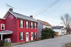 Federal St between Green and Apple | |
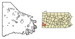 Location of Coal Center in Washington County, Pennsylvania. | |
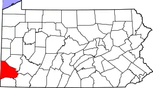
 Coal Center Location of Coal Center in Pennsylvania | |
| Coordinates: 40°4′11″N 79°54′3″W | |
| Country | United States |
| State | Pennsylvania |
| County | Washington |
| Established | 1814 |
| Government | |
| • Mayor | Frank Paterra |
| Area | |
| • Total | 0.14 sq mi (0.36 km2) |
| • Land | 0.11 sq mi (0.29 km2) |
| • Water | 0.02 sq mi (0.06 km2) |
| Population (2010) | |
| • Total | 139 |
| • Estimate (2019)[2] | 131 |
| • Density | 1,149.12/sq mi (444.18/km2) |
| Time zone | UTC-4 (EST) |
| • Summer (DST) | UTC-5 (EDT) |
| Area code(s) | 724 |
History
Developed in 1814 as Greenfield, the Borough was incorporated under that name on April 9, 1834. Enlarged on March 21, 1874, it was renamed Coal Center in Jan., 1883.
Geography
Coal Center is located at 40°4′11″N 79°54′3″W (40.069810, -79.900783).[4]
According to the United States Census Bureau, the borough has a total area of 0.1 square miles (0.26 km2), of which, 0.1 square miles (0.26 km2) of it is land and 0.04 square miles (0.10 km2) of it (14.29%) is water.
Climate
The climate in this area is characterized by hot, humid summers and generally mild to cool winters. According to the Köppen Climate Classification system, Coal Center has a humid subtropical climate, abbreviated "Cfa" on climate maps.[5]
Surrounding and adjacent neighborhoods
Coal Center has only one land border, surrounded by California to the south, southwest and west. Across the Monongahela River to the northeast, Coal Center runs adjacent with Newell in Fayette County.
Demographics

| Historical population | |||
|---|---|---|---|
| Census | Pop. | %± | |
| 1880 | 557 | — | |
| 1890 | 569 | 2.2% | |
| 1900 | 742 | 30.4% | |
| 1910 | 816 | 10.0% | |
| 1920 | 724 | −11.3% | |
| 1930 | 629 | −13.1% | |
| 1940 | 705 | 12.1% | |
| 1950 | 584 | −17.2% | |
| 1960 | 419 | −28.3% | |
| 1970 | 317 | −24.3% | |
| 1980 | 255 | −19.6% | |
| 1990 | 184 | −27.8% | |
| 2000 | 134 | −27.2% | |
| 2010 | 139 | 3.7% | |
| 2019 (est.) | 131 | [2] | −5.8% |
| Sources:[6][7][8] | |||
As of the census[7] of 2000, there were 134 people, 59 households, and 32 families residing in the borough. The population density was 1,178.5 people per square mile (470.3/km2). There were 72 housing units at an average density of 633.2 per square mile (252.7/km2). The racial makeup of the borough was 96.27% White, and 3.73% from two or more races. Hispanic or Latino of any race were 1.49% of the population. 10.5% were of Polish, 10.5% Russian, 8.9% English, 8.9% German, 8.9% Irish, 8.1% Croatian and 6.5% Italian ancestry according to Census 2000.
There were 59 households, out of which 22.0% had children under the age of 18 living with them, 28.8% were married couples living together, 25.4% had a female householder with no husband present, and 44.1% were non-families. 25.4% of all households were made up of individuals, and 15.3% had someone living alone who was 65 years of age or older. The average household size was 2.27 and the average family size was 2.79.
In the borough the population was spread out, with 17.2% under the age of 18, 20.1% from 18 to 24, 20.1% from 25 to 44, 24.6% from 45 to 64, and 17.9% who were 65 years of age or older. The median age was 38 years. For every 100 females, there were 69.6 males. For every 100 females age 18 and over, there were 58.6 males.
The median income for a household in the borough was $23,125, and the median income for a family was $28,125. Males had a median income of $26,250 versus $11,042 for females. The per capita income for the borough was $13,827. There were 18.2% of families and 28.1% of the population living below the poverty line, including 30.8% of under eighteens and 20.0% of those over 64.
References
- "2019 U.S. Gazetteer Files". United States Census Bureau. Retrieved July 28, 2020.
- "Population and Housing Unit Estimates". United States Census Bureau. May 24, 2020. Retrieved May 27, 2020.
- "Archived copy". Archived from the original on 2016-01-13. Retrieved 2017-12-06.CS1 maint: archived copy as title (link)
- "US Gazetteer files: 2010, 2000, and 1990". United States Census Bureau. 2011-02-12. Retrieved 2011-04-23.
- Climate Summary for Coal Center, Pennsylvania
- "Census of Population and Housing". U.S. Census Bureau. Retrieved 11 December 2013.
- "U.S. Census website". United States Census Bureau. Retrieved 2008-01-31.
- "Incorporated Places and Minor Civil Divisions Datasets: Subcounty Resident Population Estimates: April 1, 2010 to July 1, 2012". Population Estimates. U.S. Census Bureau. Archived from the original on 11 June 2013. Retrieved 11 December 2013.
| Counties |  Map of the Pittsburgh Tri-State with green counties in the metropolitan area and yellow counties in the combined area | |
|---|---|---|
| Major cities | ||
| Cities and towns 15k–50k (in 2010) | ||
| Airports | ||
| Topics | ||
| ||