Cyclone Peter
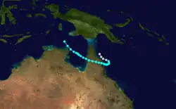
Cyclone Peter was the wettest tropical cyclone on record in Australia. The third system and first severe tropical cyclone of the 1978–79 season, Peter developed on 29 December from a weak low pressure area over the Gulf of Carpentaria. Peter moved southeastward and deepened while brushing Arnhem Land. Initially a tropical low, it strengthened into a Category 1 cyclone by 12:00 UTC on 29 December. Peter intensified further on 30 December and became a Category 2 cyclone. On the following day, the cyclone peaked with maximum sustained winds of 110 km/h (70 mph). Peter weakened to a Category 1 cyclone before making landfall near the mouth of the Edward River in Queensland. While crossing the Cape York Peninsula, the storm weakened slowly. After reaching Pacific Ocean near Cooktown, the storm decelerated and meandered offshore, but dissipated just offshore on 4 January.
| Category 3 severe tropical cyclone (Aus scale) | |
|---|---|
| tropical cyclone (SSHWS) | |
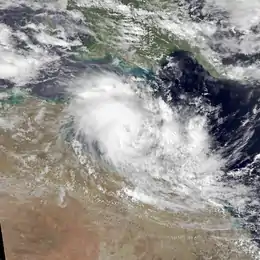
 Cyclone Peter near peak intensity on December 31 | |
| Formed | 29 December 1978 |
| Dissipated | 3 January 1979 |
| Highest winds | 10-minute sustained: 150 km/h (90 mph) 1-minute sustained: 110 km/h (70 mph) |
| Lowest pressure | 980 hPa (mbar); 28.94 inHg |
| Fatalities | 2 |
| Damage | $11.4 million (1978 USD) |
| Areas affected | Northern Territory, Queensland |
| Part of the 1978–79 Australian region cyclone season | |
While trekking slowly offshore the east coast of Queensland, the storm dropped very heavy rainfall, peaking at 1,947 millimetres (76.7 in) at Mount Bellenden Ker, making it the wettest tropical cyclone on record in Australia. Severe flooding occurred, especially in the Cairns area. The most severe damage was dealt to sugar cane, which suffered 70 to 90 percent destruction. Some flights were canceled at the Cairns Airport due to standing water. Floodwaters forced at least 50 people to flee their homes in Cairns. A number of roads, including major highways, were flooded throughout coastal areas of Far North Queensland. Rainfall and winds also resulted in many power and telephone service outages through the region. There were two fatalities and damage reached approximately $10 million (1979 AUD; $11.4 million 1979 USD).
Meteorological history

During the final week of December 1978, an area of atmospheric convection developed over northern Australia and surrounding areas.[1] During 28 December, an area of low pressure developed over the eastern Arnhem Land within this area of atmospheric convection.[1] Over the next day the system moved northwestward toward the Gulf of Carpentaria and developed further, with the first gale force wind associated with the system reported from an automatic weather station on 29 December.[1] The system was subsequently named Peter by the Australian Bureau of Meteorology (BoM) after it moved into the Gulf and developed into a Category 1 tropical cyclone on the Australian tropical cyclone intensity scale.[2] After being named, Peter continued to intensify further as it tracked southeastward toward the Cape York Peninsula.[2]
The system was subsequently considered to have peaked as a Category 2 tropical cyclone on 31 December, with 10-minute sustained winds estimated at 110 km/h (70 mph) by the BoM.[2] Several hours later, the system made landfall between Aurukun and the Edward River mission, Queensland, at around 20:00 (Australian Eastern Standard Time, 11:00 UTC).[3] As Peter made landfall during 31 December winds of 120 km/h (75 mph), were reported from both Fitzroy Island and the Edward River mission weather stations.[1] Over the next couple of days the system gradually weakened over land, before it emerged into the Coral Sea near Cooktown, Queensland, on 1 January.[4] The system subsequently weakened below tropical cyclone intensity and became a tropical low during 2 January.[5] The system was last noted on the following day as it degenerated into a complex low pressure system and moved back over the Cape York Peninsula.[4][6] The complex low subsequently moved westwards over the Peninsula and into the Gulf, where it developed into Tropical Cyclone Greta.[7]
Impact
| Precipitation | Storm | Location | Ref. | ||
|---|---|---|---|---|---|
| Rank | mm | in | |||
| 1 | 1,947 | 76.65 | Peter 1979 | Mount Bellenden Ker | [8] |
| 2 | 1,870 | 73.62 | Rona–Frank 1999 | Mount Bellenden Ker | [8] |
| 3 | 1,318 | 51.89 | Wanda 1974 | Mount Glorious | [9] |
| 4 | 1,256.8 | 49.48 | Fletcher 2014 | Kowanyama | [10][11] |
| 5 | 1,082 | 42.60 | Aivu 1989 | Dalrymple Heights | [12] |
| 6 | 1,065 | 41.93 | May 1998 | Burketown | [13] |
| 7 | 1,000 | 39.37 | Justin 1997 | Willis Island | [14] |
| 7 | 1,000 | 39.37 | Ellie 2009 | [15] | |
| 7 | 1,000 | 39.37 | Oswald 2013 | Tully | [16] |
| 8 | 986 | 38.82 | Debbie 2017 | Clarke Range | [17] |
The Darwin Tropical Cyclone Warning Centre (TCWC) in Northern Territory issued a cyclone warning on 30 December for the coast of Arnhem Land from the Wessel Islands to Port Roper, located near the mouth of the Roper River.[18] Although a cyclone warning indicates expectation of landfall,[19] Peter would never strike Northern Territory.[1] The strongest observed winds in the territory was 74 km/h (46 mph) on Northeast Island, while the highest precipitation total was 140 millimetres (5.5 in) in Nhulunbuy, 107 mm (4.2 in) of which fell in 24 hours. Very rough seas were reported along the coast of some areas, beaching a 12 m (39 ft) fishing vessel onto the rocks at Gove harbour.[2]
In Queensland, the Brisbane TCWC issued cyclone watches and flood warnings as the storm passed over the Cape York Peninsula.[20] Some areas experienced strong winds, with gusts up to 110 km/h (68 mph) at Edward River Aboriginal Mission and Fitzroy Island.[1] The storm dropped very heavy rainfall while drifting offshore Queensland, with Mount Bellenden Ker recording 1,947 mm (76.7 in) over a period of approximately three days, making Peter the wettest tropical cyclone in Australia.[21] About 1,140 mm (45 in) of that fell in a 24-hour period, which was the country's highest daily rainfall total. Other significant precipitation amounts included 433 mm (17.0 in) in Millaa Millaa and 402 mm (15.8 in) in Cooktown.[1]
Due to the heavy rainfall, severe flooding occurred, mostly between Tully and Cooktown, with the worst impact in the Cairns area.[1] Many creeks and rivers, such as the Herbert, the north and south branches of the Johnstone, and McLeod rivers overflowed or reached dangerous levels. Much of the damage in North Queensland occurred to newly planted sugar cane, with approximately 70 to 90 percent of area's crop destroyed. Twenty growers in Goondi each lost between $20,000 to $30,000 in sugar cane. Damage to this crop was comparable to the floods in 1977.[22] In total, the storm destroyed 270,000 to 315,000 tonnes of sugar cane.[23]
Standing water at Cairns Airport led Ansett Australia to cancel some flights. Portions of many roads, including major highways such as the Bruce, Captain Cook, Gillies,[20] and Kennedy highways were reported by the Royal Automobile Club as closed due to inundation and washouts.[22] Many motorists were left stranded by floodwaters on Bruce Highway.[20] Emergency personnel crews were put on standby in Innisfail as water up to 60 cm (24 in) threatened dozens of homes in the eastern part of town.[20] In Cairns, over 50 people fled their homes.[24] On 5 January, the Coast Guard of Australia began evacuating some 160 stranded campers in areas about 140 km (85 mi) north of Mossman. Foods shortages occurred in some areas of Far North Queensland, forcing several emergency food drops, including to about 250 people on 4 January and 70 people on 5 January. Additionally, a policeman was winched by helicopter to deliver food supplies to 10 isolated people on 7 January in Goldsborough, which is located in the Gillies Range to the west of Gordonvale. Overall, Peter left two fatalities and about $10 million (1979 AUD) in damage, at least $4.5 million of which was done to sugar cane in Babinda, Innisfail, and Tully.[22]
After the storm, the Government of Queensland declared the Cairns area as a natural disaster area. About week later, the Cabinet supported a measure by Minister for Primary Industries, Vic Sullivan, to offer low-interest loans to farmer who lost significant amounts of crops and livestock.[3] Later, Queensland Premier Joh Bjelke-Petersen requested aid from the national government. Prime Minister Malcolm Fraser approved low-interest loans up to $25,000 (1979 AUD) for small businesses and the implementation of other measures for recovery.[25]
See also
References
- Tropical Cyclone Peter: 29 December 1978 – 2 January 1979 (Report). Australian Bureau of Meteorology. Archived from the original on 24 January 2016. Retrieved 14 January 2016.
- Tropical Cyclone Peter: December 29 – 31, 1978 (Report). Australian Bureau of Meteorology. Archived from the original on 23 January 2016. Retrieved 23 January 2016.
- Christopher Salisbury. Cabinet Minutes 1979 – Selected Highlights (PDF) (Report). Brisbane, Queensland: Government of Queensland. p. 1. Retrieved 14 January 2016.
- "The Australian Tropical Cyclone Database" (CSV). Australian Bureau of Meteorology. A guide on how to read the database is available here.
- "Telephones, roads cut by cyclone". The Canberra Times. 3 January 1979. p. 3. Retrieved 25 January 2016.
- "Flooding, food shortages in north Qld". The Canberra Times. 4 January 1979. p. 3. Retrieved 25 January 2016.
- L. W. Broadbridge (1 September 1979). "The Australian Tropical Cyclone Season 1978–79" (PDF). Australian Meteorological Magazine. Australian Bureau of Meteorology. Retrieved 1 January 2016.
- "Climate Education: Flood". Australian Bureau of Meteorology. Archived from the original on 17 March 2009. Retrieved 18 January 2011.
- Bureau of Meteorology. Tropical Cyclones in Queensland. Retrieved on 17 July 2015.
- "Tropical Cyclone Fletcher Impacts". Bureau of Meteorology. Government of Australia. 2014. Retrieved 5 March 2014.
- "Kowanyama, Queensland February 2014 Daily Weather Observations" (PDF). Bureau of Meteorology. Government of Australia. 2014. Archived from the original (PDF) on 6 March 2014. Retrieved 6 March 2014.
- "Report on Severe Tropical Cyclone Aivu: Rainfall" (PDF). Bureau of Meteorology. Government of Australia. 6 June 1990. p. 17–18. Retrieved 13 March 2014.
- "Tropical Cyclone May". Australian Bureau of Meteorology. 2013. Retrieved 29 January 2013.
- Queensland Tropical Cyclone Warning Centre (2014). "Tropical Cyclone Justin" (PDF). Australian Bureau of Meteorology. Retrieved 11 March 2014.
- "Tropical Cyclone Ellie". Australian Bureau of Meteorology. 2009. Retrieved 27 January 2013.
- Williams, Brian; Michael, Peter (24 January 2013). "Ex-cyclone Oswald heads south with heavy rain tipped for long weekend". The Courier Mail. Australian Associated Press. Archived from the original on 24 January 2013. Retrieved 24 January 2013.
- http://www.bom.gov.au/announcements/sevwx/qld/qldtc20170325.shtml
- "Ship caught in cyclone". The Canberra Times. Darwin, Northern Territory. 31 December 1978. p. 3. Retrieved 15 January 2016.
- "Tropical Cyclone Warning Advice". Bureau of Meteorology. Retrieved 15 January 2016.
- "Telephone, roads cut by cyclone". The Canberra Times. Brisbane, Queensland. 3 January 1979. p. 3. Retrieved 14 January 2016.
- Australia's Record Rainfall (Report). Bureau of Meteorology. Retrieved 23 January 2016.
- "Damage to sugar cane 'in millions'". The Canberra Times. Brisbane, Queensland. 7 January 1979. p. 3. Retrieved 14 January 2016.
- "North Queensland cane losses estimated". South African Sugar Journal. Cornell University. 63: 5. 1979. ISSN 0038-2728. Retrieved 14 January 2016.
- "Flooding, food shortages in north Qld". The Canberra Times. Brisbane, Queensland. 4 January 1979. p. 3. Retrieved 15 January 2016.
- "Commonwealth Assistance to Queensland in Respect of Cyclone Peter". Department of the Prime Minister and Cabinet. 18 January 1979. Archived from the original on 29 January 2016. Retrieved 14 January 2016.