Darende
Darende is a district of Malatya Province of Turkey. The mayor is Süleyman Eser (AKP).
Darende | |
|---|---|
 | |
 Darende | |
| Coordinates: 38°32′50″N 37°30′40″E | |
| Country | |
| Province | Malatya |
| Government | |
| • Mayor | Süleyman Eser (AKP) |
| • Kaymakam | Murat Uzunparmak |
| Area | |
| • District | 1,362.62 km2 (526.11 sq mi) |
| Elevation | 958 m (3,143 ft) |
| Population (2012)[2] | |
| • Urban | 9,764 |
| • District | 29,386 |
| • District density | 22/km2 (56/sq mi) |
| Post code | 447xx |
| Website | www.darende.bel.tr |
Information
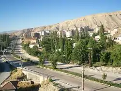
Darende is located in Malatya district. Darende was a centre of science and culture, during the ancient silk road times. The city centre is situated on the East Anatolia Region where there is a statue of a big door that was the entrance of the city Malatya. The largest district of Malatya is Darende. Darende is located in the west of the city also placed on the trade route that is on the upper part of Euphrate (Firat) and on the valley of Tohma where ancient caravans passed. The district, placed on the road between Ankara and Istanbul have as borders Hekimhan on the South of Akçadağ, on the southern west part of Gürün, and North of Kuluncak and Kangal. It has 1540m2 area. Its height above sea level is 1006 m.
History
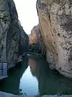
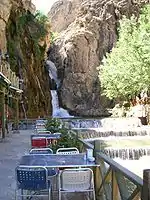
Darende has a long history, being in the centre of different civilizationes. Until 1914 the population of Darende was quite diverse, the city had an Armenian population of 3,983, with 3 Armenian churches and schools, which had about 300 pupils. After the events of 1915 only a small minority of Armenians stayed, those who stayed secretly changed the names for Islamic names to avoid further repression. Since the founding of modern Turkey, Darende has grown in population. The surrounding geography includes the Tohma River flows in Darende abundantly. In 1934, it was one of the districts of Sivas, but because of cultural, climatic and regional similarities, Darende became one of the districts of Malatya . The city sustained its popularity in the First period of Turkish Republic.
Balaban, Aşaği Ulupinar, Yenice, Ayvali, Ilica and Ağilbaşi towns, and there are 44 villages in Darende. It was called as Timelkie, Tiranda, Tiryandafil and Derindere in history and at present it is called Darende. The Zengibar Castle is the symbol of the district. It is one of the interesting castles of Turkey that is built on rocks. The castle was built during the Hittite and Urartu civilizations. The castle has an entrance gate, the King’s house and graves remnants. There are three graves of Sahabe and they are on the field of “HU DEDE” which is on the slopes of castle. Darende had been conquered by Halid Bin Velid whose army hadn’t been defeated in any time and since then it has been centre of belief and culture. Seyyid Abdurrahman Gazi had been martyred on this land while he was a soldier of Holy Army fighting for the Conquest of Istanbul.
Hasan gazi (who was uncle and father in law of Seyyid Battal Gazi) died while serving the Ottoman State and Islam. He is buried on the hill that now bears his name. The tomb of Hasan Gazi which reminds Huseyin’s holiness on Karbala attracts visitors' interest.
According to some Muslim ideologies those who died for Islam show deed to all humanity all over the world. Abdurrahman Erzincani mosque and its complex is a frequented place for visitors. Its historical bridges, Ozan monument, Danabey Masjid, Great mosque, Mehmet Paşa Mosque complex, Ibrahim paşa Mosque and the minarets that their mosques represent the history of the district. There are current projects of the directorate general of foundations, DGOF, to restore the minarets. There are historical richesness such as Aslantaşlar(Lion Stones) 20 km away from Darende situated on the northern part of the district.
Two rocks that could not be known their date meet you when you go there. (Divriği, Gürün, Eğin, Arapgir and Darende)
According to rumours these statues of lions were pieces of a temple in ancient times. Their faces look at the side sun rises.
Transportation
Darende is on the D300 highway which links Ankara and Istanbul to Malatya and some 12 other cities .
The distance to Malatya is 110 km Sivas 180 km and Kayseri 250 km. The arrival from Darende to other cities is done by the long-distance bus.
There is also the Erhaç Airport which has flights to Ankara and Istanbul every day. It is 80 km away Darende.
Administrative Construction
The innovation of the development in Darende is es-seyyid Osman Hulusi efendi foundation focuses on different areas such as education, health, cultural and social help. Currently there is a project that includes Darende´s state Hospital.
Economy
Darende is a centre of culture and tourism. There is some production of ready-made clothes. There are also some traditional jobs like coppersmiths, blacksmiths, carpenters and shoemakers.
During Darende´s summer temperature rise and winter can be quite cold.
Apricot production
The most important income is apricot. There are approximately 1.5 million apricot trees in Darende. Apricot in Darende covers %25 per cent of total apricot production in Malatya. Mişmiş (the local name of apricot) is locally known for improving some health condition such as cardiac, insufficiency, nephirity, indigestion, cancer, anemia, asteolysis. Apples, pear, plum, mulberry, cherry, grape are also produced in Darende. With the Gökpinar watering Project this production will be possible all year around providing a stable income.
Cultural Activities
In summer there are festivals and some other activities in Darende. In June, especially, Darende somuncu baba and Hulusi efendi cultural festivals influence everybody in Turkey. In July there are some other activities such as wrestling and culture festival on 30 August circumcise feast music feast, karakucak wrestling feast… Those feast are done by the help Osman Hulusi efendi foundation. Worldwide popular circumciser Mr. Kemal Özkan helps to circumcise feast.
Education
The literacy rate in Darende is very high.
Schools
- Private Birgul Primary School in Darende Official web site
Important culture centres
- The library founded by Sadrazam Mehmet
- Somuncu baba library in somuncu baba kulliye
References
- "Area of regions (including lakes), km²". Regional Statistics Database. Turkish Statistical Institute. 2002. Retrieved 2013-03-05.
- "Population of province/district centers and towns/villages by districts - 2012". Address Based Population Registration System (ABPRS) Database. Turkish Statistical Institute. Retrieved 2013-02-27.
External links
Darende in Malatya Province of Turkey | |||||||||||||||||||||||||||
|---|---|---|---|---|---|---|---|---|---|---|---|---|---|---|---|---|---|---|---|---|---|---|---|---|---|---|---|
| Districts | 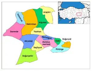 Districts of Malatya | ||||||||||||||||||||||||||
| |||||||||||||||||||||||||||
Metropolitan municipalities are bolded. | |||||||||||||||||||||||||||
