Dateland, Arizona
Dateland is both a CDP and a populated place in Yuma County, Arizona, United States. It is in an area well known for date palm dates.
Dateland, Arizona | |
|---|---|
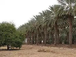 Rows of date palms behind the Dateland Travel Center. | |
 Location of Dateland in Yuma County, Arizona. | |
 Dateland, Arizona Location within the state of Arizona  Dateland, Arizona Dateland, Arizona (the United States) | |
| Coordinates: 32°49′15″N 113°32′31″W | |
| Country | United States |
| State | Arizona |
| County | Yuma |
| Area | |
| • Total | 22.09 sq mi (57.21 km2) |
| • Land | 22.09 sq mi (57.21 km2) |
| • Water | 0.00 sq mi (0.00 km2) |
| Elevation | 436 ft (133 m) |
| Population (2010) | |
| • Total | 416 |
| • Estimate (2016)[3] | N/A |
| Time zone | UTC-7 (Mountain (MST)) |
| ZIP codes | 85333 |
| FIPS code | 04-18160 |
| GNIS feature ID | 2582769 |
Dateland has the ZIP Code of 85333; in 2000, the population of the 85333 ZCTA was 852.[4]
The community is part of the Yuma Metropolitan Statistical Area.
The Dateland Food Court is home to the self-proclaimed "World Famous Date Shakes."
History
Dateland began as a road stop in the 1920s. During World War II, Dateland was home to Dateland Air Force Auxiliary Field. After the closure of the airfield, the land was subdivided in the 1970s. The developers of one subdivision on the former airfield, El Camino Del Sol, were convicted of fraud in 1977.[6][7] Most of Dateland consists of undeveloped lots.[8]
Climate
This area has a large amount of sunshine year round due to its stable descending air and high pressure. According to the Köppen Climate Classification system, Dateland has a desert climate, abbreviated "Bwh" on climate maps.[9]
| Climate data for Dateland | |||||||||||||
|---|---|---|---|---|---|---|---|---|---|---|---|---|---|
| Month | Jan | Feb | Mar | Apr | May | Jun | Jul | Aug | Sep | Oct | Nov | Dec | Year |
| Record high °F (°C) | 88 (31) |
94 (34) |
100 (38) |
106 (41) |
115 (46) |
120 (49) |
122 (50) |
120 (49) |
114 (46) |
108 (42) |
99 (37) |
89 (32) |
122 (50) |
| Average high °F (°C) | 69 (21) |
73 (23) |
79 (26) |
86 (30) |
95 (35) |
103 (39) |
106 (41) |
105 (41) |
101 (38) |
89 (32) |
78 (26) |
68 (20) |
88 (31) |
| Daily mean °F (°C) | 55 (13) |
58 (14) |
63 (17) |
69 (21) |
77 (25) |
85 (29) |
91 (33) |
91 (33) |
85 (29) |
73 (23) |
62 (17) |
54 (12) |
72 (22) |
| Average low °F (°C) | 41 (5) |
43 (6) |
47 (8) |
52 (11) |
58 (14) |
66 (19) |
75 (24) |
76 (24) |
69 (21) |
57 (14) |
46 (8) |
39 (4) |
56 (13) |
| Record low °F (°C) | 22 (−6) |
25 (−4) |
30 (−1) |
32 (0) |
36 (2) |
49 (9) |
54 (12) |
55 (13) |
49 (9) |
35 (2) |
25 (−4) |
17 (−8) |
17 (−8) |
| Average precipitation inches (mm) | 0.7 (18) |
0.5 (13) |
0.4 (10) |
0.2 (5.1) |
0 (0) |
0 (0) |
0.4 (10) |
0.6 (15) |
0.5 (13) |
0.4 (10) |
0.4 (10) |
0.7 (18) |
4.8 (122.1) |
| Source: [10] | |||||||||||||
References
- "2016 U.S. Gazetteer Files". United States Census Bureau. Retrieved Jul 18, 2017.
- "Feature Detail Report for: Dateland Census Designated Place". Geographic Names Information System. United States Geological Survey.
- "Population and Housing Unit Estimates". Retrieved June 9, 2017.
- "Archived copy". Archived from the original on 2020-02-12. Retrieved 2010-07-12.CS1 maint: archived copy as title (link)
- "Census of Population and Housing". Census.gov. Retrieved June 4, 2016.
- "Grand Jury Indicts 11 In County Land Fraud". Yuma Daily Sun. 1975-11-20. p. 1.
- "Trio sentenced by U.S. court for land fraud". Eugene Register-Guard. 1977-03-22. pp. 3–.
- Yuma County 2020 Comprehensive Plan Section Three - Land Use Element
- Climate Summary for Dateland, Arizona
- "Monthly Average/Record Temperatures". Weather Channel. Retrieved 31 August 2015.
External links
 Media related to Dateland, Arizona at Wikimedia Commons
 Dateland travel guide from Wikivoyage
- Dateland community website
Municipalities and communities of Yuma County, Arizona, United States | ||
|---|---|---|
| Cities | 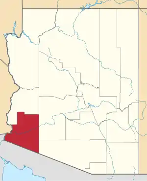 | |
| Town | ||
| CDPs | ||
| Populated places | ||
| Indian reservations | ||
| Ghost towns | ||
| Footnotes | ‡This populated place also has portions in an adjacent county or counties | |
| ||
