East Brandywine Township, Chester County, Pennsylvania
East Brandywine Township is a township in Chester County, Pennsylvania, United States. The population was 6,742 at the 2010 census.
East Brandywine Township | |
|---|---|
 | |
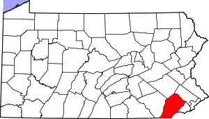
 Location in Chester County and the state of Pennsylvania. | |
.svg.png.webp) Location of Pennsylvania in the United States | |
| Coordinates: 40°01′55″N 75°44′53″W | |
| Country | United States |
| State | Pennsylvania |
| County | Chester |
| Area | |
| • Total | 11.26 sq mi (29.15 km2) |
| • Land | 11.15 sq mi (28.89 km2) |
| • Water | 0.10 sq mi (0.26 km2) |
| Elevation | 577 ft (176 m) |
| Population (2010) | |
| • Total | 6,742 |
| • Estimate (2016)[2] | 8,409 |
| • Density | 753.97/sq mi (291.12/km2) |
| Time zone | UTC-5 (EST) |
| • Summer (DST) | UTC-4 (EDT) |
| Area code(s) | 610 |
| FIPS code | 42-029-20864 |
| Website | www |
History
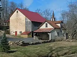
The Bridge Mill Farm and Marshall's Bridge are listed on the National Register of Historic Places.[3]
Demographics
At the 2010 census, the township was 93.3% non-Hispanic White, 1.4% Black or African American, 0.1% Native American, 2.2% Asian, 0.1% Native Hawaiian or other Pacific Islander, and 1.2% were two or more races. 1.8% of the population were of Hispanic or Latino ancestry.[5]
At the 2000 census there were 5,822 people, 2,003 households, and 1,644 families living in the township. The population density was 511.3 people per square mile (197.4/km2). There were 2,035 housing units at an average density of 178.7/sq mi (69.0/km2). The racial makeup of the township was 96.62% White, 1.25% African American, 0.10% Native American, 1.15% Asian, 0.02% Pacific Islander, 0.07% from other races, and 0.79% from two or more races. Hispanic or Latino of any race were 0.52%.[6]
There were 2,003 households, 41.1% had children under the age of 18 living with them, 71.5% were married couples living together, 7.8% had a female householder with no husband present, and 17.9% were non-families. 14.5% of households were made up of individuals, and 3.4% were one person aged 65 or older. The average household size was 2.90 and the average family size was 3.23.
The age distribution was 28.9% under the age of 18, 6.2% from 18 to 24, 28.3% from 25 to 44, 29.1% from 45 to 64, and 7.6% 65 or older. The median age was 39 years. For every 100 females, there were 98.3 males. For every 100 females age 18 and over, there were 94.1 males.
The median household income was $76,217 and the median family income was $81,886. Males had a median income of $54,327 versus $30,611 for females. The per capita income for the township was $32,178. About 1.0% of families and 1.9% of the population were below the poverty line, including 1.7% of those under age 18 and 6.0% of those age 65 or over.
Geography
According to the United States Census Bureau, the township has a total area of 11.4 square miles (30 km2), all of it land.
References
- "2016 U.S. Gazetteer Files". United States Census Bureau. Retrieved Aug 13, 2017.
- "Population and Housing Unit Estimates". Retrieved June 9, 2017.
- "National Register Information System". National Register of Historic Places. National Park Service. July 9, 2010.
- http://www.dvrpc.org/data/databull/rdb/db82/appedixa.xls
- https://www.usatoday.com/news/nation/census/profile/PA
- "U.S. Census website". United States Census Bureau. Retrieved 2008-01-31.
External links
| Wikimedia Commons has media related to East Brandywine Township, Chester County, Pennsylvania. |
Places adjacent to East Brandywine Township, Chester County, Pennsylvania | ||||||||||
|---|---|---|---|---|---|---|---|---|---|---|
| ||||||||||