Thornbury Township, Chester County, Pennsylvania
Thornbury Township is a township in Chester County, Pennsylvania, United States. The population was 3,017 at the 2010 census. It is adjacent to, and was once joined with, Thornbury Township, Delaware County, Pennsylvania.
Thornbury | |
|---|---|
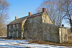 The Squire Cheyney Farm, a historic site in the township | |
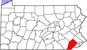
 Location in Chester County and the U.S. state of Pennsylvania. | |
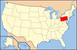 Location of Pennsylvania in the United States | |
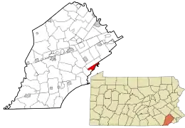
 Thornbury Location of Thornbury Township in Pennsylvania | |
| Coordinates: 39°55′50″N 75°32′43″W | |
| Country | United States |
| State | Pennsylvania |
| County | Chester |
| Area | |
| • Total | 3.87 sq mi (10.01 km2) |
| • Land | 3.83 sq mi (9.93 km2) |
| • Water | 0.03 sq mi (0.08 km2) |
| Elevation | 249 ft (76 m) |
| Population (2010) | |
| • Total | 3,017 |
| • Estimate (2016)[2] | 3,146 |
| • Density | 820.77/sq mi (316.89/km2) |
| Time zone | UTC-5 (EST) |
| • Summer (DST) | UTC-4 (EDT) |
| Area code(s) | 610 |
| FIPS code | 42-029-76568 |
| Website | www |
History
Thornbury Township was organized in 1687 with the appointment of Hugh Durborrow as constable and received its name from Thornbury, in Gloucestershire, England. At the time, no more than five or six families lived within the limits of the township. George Peirce, one of the earliest and most influential inhabitants of the township, was married to a native of Thornbury, England, and the township was purportedly named to compliment her. Thornbury, Birmingham and Westtown townships are the only townships within the present limits of Chester County which were organized before 1704.[3]
The township was divided when Delaware County was separated from Chester County in 1798. As a result, there is a Thornbury Township in each county. Landowners were allowed to choose which county they wished to be in, causing the line between the two townships, and the two counties, to be very irregular.[3][4][5]
The Battle of Brandywine, part of the American Revolutionary War took place partially in the town. It was one of Thornbury's citizens, Squire Thomas Cheyney, who informed George Washington, commander of the Continental Army, of the approach of the British troops.[6][7]
The Squire Cheyney Farm and William J. Barnard Residence are listed on the National Register of Historic Places.[8]
Points of interest
Entries in the National Register of Historic Places
Geography
According to the United States Census Bureau, the township has a total area of 3.9 square miles (10 km2), all of it land.
Demographics
| Historical population | |||
|---|---|---|---|
| Census | Pop. | %± | |
| 1930 | 244 | — | |
| 1940 | 233 | −4.5% | |
| 1950 | 297 | 27.5% | |
| 1960 | 746 | 151.2% | |
| 1970 | 803 | 7.6% | |
| 1980 | 1,323 | 64.8% | |
| 1990 | 1,131 | −14.5% | |
| 2000 | 2,678 | 136.8% | |
| 2010 | 3,017 | 12.7% | |
| 2016 (est.) | 3,146 | [2] | 4.3% |
| [15] | |||
At the 2010 census, the township was 85.5% non-Hispanic White, 3.4% Black or African American, 0.1% Native American, 7.6% Asian, and 1.4% were two or more races. 1.9% of the population were of Hispanic or Latino ancestry.[16]
As of the census[17] of 2000, there were 2,678 people, 1,023 households, and 734 families residing in the township. The population density was 684.8 people per square mile (264.4/km2). There were 1,095 housing units at an average density of 280.0/sq mi (108.1/km2). The racial makeup of the township was 91.90% White, 2.58% African American, 4.56% Asian, 0.04% Pacific Islander, 0.22% from other races, and 0.71% from two or more races. Hispanic or Latino of any race were 0.78% of the population.
There were 1,023 households, out of which 33.6% had children under the age of 18 living with them, 65.6% were married couples living together, 4.2% had a female householder with no husband present, and 28.2% were non-families. 22.6% of all households were made up of individuals, and 3.0% had someone living alone who was 65 years of age or older. The average household size was 2.60 and the average family size was 3.10.
In the township the population was spread out, with 26.0% under the age of 18, 5.4% from 18 to 24, 34.8% from 25 to 44, 26.7% from 45 to 64, and 7.2% who were 65 years of age or older. The median age was 37 years. For every 100 females there were 95.6 males. For every 100 females age 18 and over, there were 95.6 males.
The median income for a household in the township was $84,225, and the median income for a family was $112,291. Males had a median income of $70,602 versus $42,371 for females. The per capita income for the township was $47,505. None of the families and 1.6% of the population were living below the poverty line, including no people under eighteen, and 2.0% of those over 64.
Education
The West Chester Area School District operates public schools serving the township.[18] Elementary schools serving sections include Penn Wood, Sarah Starkweather, and Westtown-Thornbury.[19] All residents are zoned to Stetson Middle School and West Chester Rustin High School.[20]
Notable people
- Francis James (1799–1886), U.S. Representatives for Pennsylvania from 1839 to 1843
- Daniel Garrison Brinton (1837–1899), historian and ethnologist
References
- "2016 U.S. Gazetteer Files". United States Census Bureau. Retrieved Aug 13, 2017.
- "Population and Housing Unit Estimates". Retrieved June 9, 2017.
- Futhey, J. Smith; Gilbert Cope (1881). History of Chester County, Pennsylvania, with Genealogical and Biographical Sketches. Louis H. Everts. ISBN 0-7884-0206-4.
- LL.D. Jordan, John W. (1914). A History of Delaware County, Pennsylvania and its People. New York, NY:Lewis Historical Publishing Company.
- History of Thornbury Township, Pa
- Wood, W.J.; John S.D. Eisenhower (1990). Battles of the Revolutionary War: 1775-1781. Chapel Hill, N.C.: Algonquin Books of Chapel Hill. ISBN 0-306-80617-7.
- "About the Twp". Archived from the original on 2006-05-02. Retrieved 2006-04-30.
- "National Register Information System". National Register of Historic Places. National Park Service. July 9, 2010.
- PHMC Cultural Resources Database
- GROWTH by BEAUTIFICATION - Cheyney University campus undergoes renovations
- Cheyney Timeline Archived 2007-11-18 at the Wayback Machine
- Barnard Residence - Philadelphia Architects and Buildings
- "Taylor Frazer Ruins". Archived from the original on 2009-01-06. Retrieved 2008-05-20.
- POLLY FRAZER An Unsung Heroine’s Story
- http://www.dvrpc.org/data/databull/rdb/db82/appedixa.xls
- "U.S. Census website". United States Census Bureau. Retrieved 2008-01-31.
- "West Chester Area Council of Governments Map." On the website of West Goshen Township. Retrieved on September 26, 2018.
- "School Boundary Adjustment Draft SK8C - Current Boundaries with Zones of Change" (Elementary). West Chester Area School District. Retrieved on September 26, 2018.
- "School Boundary Adjustment Draft SK8C - Current Boundaries with Zones of Change" (Secondary). West Chester Area School District. Retrieved on September 26, 2018.
External links
| Wikimedia Commons has media related to Thornbury Township, Chester County, Pennsylvania. |