East Coventry Township, Chester County, Pennsylvania
East Coventry Township is a township in Chester County, Pennsylvania, United States. The population was 6,636 at the 2010 census.
East Coventry Township | |
|---|---|
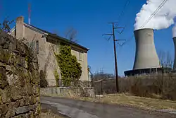 Abandoned house in Frick's Lock, with the Limerick Nuclear Plant in the background | |
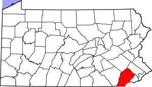
 Location in Chester County and the state of Pennsylvania. | |
.svg.png.webp) Location of Pennsylvania in the United States | |
| Coordinates: 40°12′00″N 75°37′35″W | |
| Country | United States |
| State | Pennsylvania |
| County | Chester |
| Area | |
| • Total | 10.91 sq mi (28.26 km2) |
| • Land | 10.66 sq mi (27.62 km2) |
| • Water | 0.25 sq mi (0.64 km2) |
| Elevation | 243 ft (74 m) |
| Population (2010) | |
| • Total | 6,636 |
| • Estimate (2016)[2] | 6,730 |
| • Density | 631.10/sq mi (243.67/km2) |
| Time zone | UTC-5 (EST) |
| • Summer (DST) | UTC-4 (EDT) |
| Area code(s) | 610 |
| FIPS code | 42-029-21008 |
| Website | www |
History
The township derives its name from Coventry, England, the native home of an early settler.[3]
Fricks Locks Historic District, and River Bend Farm are listed on the National Register of Historic Places.[4]
Geography
According to the United States Census Bureau, the township has a total area of 11.0 square miles (28 km2), of which 10.8 square miles (28 km2) is land and 0.2 square miles (0.52 km2), or 1.55%, is water. The township includes the unincorporated community of Parker Ford.
Adjacent townships
Demographics
At the 2010 census, the township was 92.5% non-Hispanic White, 3.1% Black or African American, 0.1% Native American, 1.4% Asian, and 1.4% were two or more races. 1.7% of the population were of Hispanic or Latino ancestry.[5]
As of the census[6] of 2000, there were 4,566 people, 1,649 households, and 1,246 families residing in the township. The population density was 423.4 people per square mile (163.5/km2). There were 1,684 housing units at an average density of 156.2/sq mi (60.3/km2). The racial makeup of the township was 98.38% White, 0.85% African American, 0.11% Native American, 0.22% Asian, 0.18% from other races, and 0.26% from two or more races. Hispanic or Latino of any race were 0.70% of the population.
There were 1,649 households, out of which 32.7% had children under the age of 18 living with them, 66.5% were married couples living together, 6.8% had a female householder with no husband present, and 24.4% were non-families. 20.4% of all households were made up of individuals, and 9.2% had someone living alone who was 65 years of age or older. The average household size was 2.64 and the average family size was 3.05.
In the township the population was spread out, with 23.4% under the age of 18, 5.2% from 18 to 24, 25.8% from 25 to 44, 27.3% from 45 to 64, and 18.2% who were 65 years of age or older. The median age was 43 years. For every 100 females, there were 91.0 males. For every 100 females age 18 and over, there were 86.2 males.
| Historical population | |||
|---|---|---|---|
| Census | Pop. | %± | |
| 1930 | 1,271 | — | |
| 1940 | 1,304 | 2.6% | |
| 1950 | 1,499 | 15.0% | |
| 1960 | 2,183 | 45.6% | |
| 1970 | 3,284 | 50.4% | |
| 1980 | 4,085 | 24.4% | |
| 1990 | 4,450 | 8.9% | |
| 2000 | 4,566 | 2.6% | |
| 2010 | 6,636 | 45.3% | |
| 2016 (est.) | 6,730 | [2] | 1.4% |
| [7] | |||
The median income for a household in the township was $58,125, and the median income for a family was $68,384. Males had a median income of $48,750 versus $32,031 for females. The per capita income for the township was $27,257. About 2.0% of families and 1.9% of the population were below the poverty line, including 0.9% of those under age 18 and none of those age 65 or over.
Notable people
- Grover C. Talbot, Pennsylvania State Representative for Delaware County (1925-1934), 116th Speaker of the Pennsylvania House of Representatives (1933-1934)
Points of interest
- Fricks Locks Historic District, an 18th-century village along the Schuylkill Canal
See also
References
- "2016 U.S. Gazetteer Files". United States Census Bureau. Retrieved Aug 13, 2017.
- "Population and Housing Unit Estimates". Retrieved June 9, 2017.
- "Church's 200th anniversary". Reading Eagle. Nov 10, 1924. p. 11. Retrieved 2 December 2015.
- "National Register Information System". National Register of Historic Places. National Park Service. July 9, 2010.
- https://www.usatoday.com/news/nation/census/profile/PA
- "U.S. Census website". United States Census Bureau. Retrieved 2008-01-31.
- http://www.dvrpc.org/data/databull/rdb/db82/appedixa.xls