Upper Uwchlan Township, Chester County, Pennsylvania
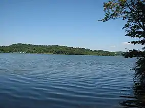
Upper Uwchlan Township (/ˈjuːklən/; [ˈɪuxlan]) is a township in Chester County, Pennsylvania, United States. The population was 11,227 at the 2010 census. The township included the community of Milford Mills before it was inundated by the creation of the Marsh Creek Dam in 1972.
Upper Uwchlan Township | |
|---|---|
 Fall colors in Upper Uwchlan Township, Pennsylvania | |
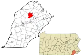 Location in Chester County and the state of Pennsylvania. | |
.svg.png.webp) Location of Pennsylvania in the United States | |
| Coordinates: 40°05′18″N 75°41′58″W | |
| Country | United States |
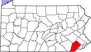
| State | Pennsylvania |
| County | Chester |
| Area | |
| • Total | 11.72 sq mi (30.36 km2) |
| • Land | 10.89 sq mi (28.21 km2) |
| • Water | 0.83 sq mi (2.15 km2) |
| Elevation | 469 ft (143 m) |
| Population (2010) | |
| • Total | 11,227 |
| • Estimate (2016)[2] | 11,500 |
| • Density | 1,055.72/sq mi (407.60/km2) |
| Time zone | UTC-5 (EST) |
| • Summer (DST) | UTC-4 (EDT) |
| ZIP Code | 19480 |
| Area code(s) | 484, 610, 835 |
| FIPS code | 42-029-79352 |
| Website | www |
The main population center of the township has grown surrounding the historic Eagle Tavern at the intersection of Route 100 and Little Conestoga Road. This major unincorporated community is known as the village of Eagle, but also sometimes known as Uwchlan. That is the address of the local post office.
History
The Byers Station Historic District, West Vincent Highlands Historic District, Larkin Covered Bridge, and Wheelen House are listed on the National Register of Historic Places.[3]
Geography
According to the United States Census Bureau, the township has a total area of 11.6 square miles (30 km2), of which 10.8 square miles (28 km2) is land and 0.9 square miles (2.3 km2), or 7.33%, is water.
Demographics
At the 2010 census, the township was 80.8% non-Hispanic White, 1.4% Black or African American, 14.1% Asian, and 1.3% were two or more races. 2.4% of the population were of Hispanic or Latino ancestry.[4]
As of the census[5] of 2000, there were 6,850 people, 2,132 households, and 1,874 families residing in the township. The population density was 637.2 people per square mile (246.0/km2). There were 2,167 housing units at an average density of 201.6/sq mi (77.8/km2). The racial makeup of the township was 97.40% White, 0.70% African American, 0.06% Native American, 1.12% Asian, 0.20% from other races, and 0.51% from two or more races. Hispanic or Latino of any race were 0.96% of the population.
There were 2,132 households, out of which 55.0% had children under the age of 18 living with them, 81.7% were married couples living together, 4.5% had a female householder with no husband present, and 12.1% were non-families. 9.7% of all households were made up of individuals, and 1.8% had someone living alone who was 65 years of age or older. The average household size was 3.21 and the average family size was 3.46.
| Historical population | |||
|---|---|---|---|
| Census | Pop. | %± | |
| 1930 | 597 | — | |
| 1940 | 689 | 15.4% | |
| 1950 | 761 | 10.4% | |
| 1960 | 909 | 19.4% | |
| 1970 | 996 | 9.6% | |
| 1980 | 1,805 | 81.2% | |
| 1990 | 4,396 | 143.5% | |
| 2000 | 6,850 | 55.8% | |
| 2010 | 11,227 | 63.9% | |
| 2016 (est.) | 11,500 | [2] | 2.4% |
| [6] | |||
In the township the population was spread out, with 35.0% under the age of 18, 4.8% from 18 to 24, 32.5% from 25 to 44, 23.7% from 45 to 64, and 4.0% who were 65 years of age or older. The median age was 35 years. For every 100 females, there were 100.1 males. For every 100 females age 18 and over, there were 97.7 males.
The median income for a household in the township was $96,711, and the median income for a family was $101,895. Males had a median income of $76,206 versus $37,404 for females. The per capita income for the township was $33,256. About 2.0% of families and 2.5% of the population were below the poverty line, including 3.8% of those under age 18 and 6.7% of those age 65 or over.
Transportation

Upper Uwchlan Township is traversed by only one main state route, Route 100. PA Route 401 skims the northeastern edge of the township as well; the two routes meet in West Vincent Township. The Pennsylvania Turnpike/Interstate 76 also cuts through the township, crossing over Route 100 in the far southern section of the township. The actual double trumpet interchange between the two roads, however, is located a mile and a half south of the overpass, in Uwchlan Township.
Public transportation is not available in Upper Uwchlan Township.
Education
It is in the Downingtown Area School District.[7]
Places of worship
Saint Elizabeth, a Catholic church, is located at 100 Fellowship Road, at Pottstown Pike. Just south of it, on Pottstown Pike, is Beth Israel Congregation of Chester County (founded 1904), Upper Uwchlan's only synagogue.

See also
References
- "2016 U.S. Gazetteer Files". United States Census Bureau. Retrieved Aug 13, 2017.
- "Population and Housing Unit Estimates". Retrieved June 9, 2017.
- "National Register Information System". National Register of Historic Places. National Park Service. July 9, 2010.
- https://www.usatoday.com/news/nation/census/profile/PA
- "U.S. Census website". United States Census Bureau. Retrieved 2008-01-31.
- http://www.dvrpc.org/data/databull/rdb/db82/appedixa.xls
- "The Municipalities". Downington Area School District. Retrieved 2020-04-24.
- "Zonong Map". Upper Uwchlan Township. Retrieved 2020-04-24.
- "Home". St. Elizabeth School. Retrieved 2020-04-24.
External links
| Wikimedia Commons has media related to Upper Uwchlan Township, Chester County, Pennsylvania. |
| Authority control |
|---|