Transylvania County, North Carolina
Transylvania County is a county in the U.S. state of North Carolina. Its 2018 U.S. Census population estimate is 34,215.[1] Its county seat is Brevard.[2]
Transylvania County | |
|---|---|
Transylvania County Courthouse in Brevard | |
Seal | |
Location within the U.S. state of North Carolina | |
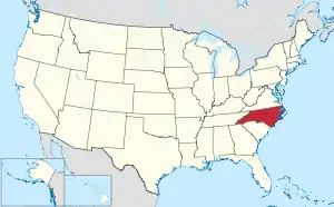 North Carolina's location within the U.S. | |
| Coordinates: 35.20°N 82.80°W | |
| Country | |
| State | |
| Founded | 1861 |
| Named for | The Transylvania Company |
| Seat | Brevard |
| Largest city | Brevard |
| Area | |
| • Total | 381 sq mi (990 km2) |
| • Land | 379 sq mi (980 km2) |
| • Water | 2.0 sq mi (5 km2) 0.5%% |
| Population | |
| • Estimate (2018) | 34,215 |
| • Density | 87/sq mi (34/km2) |
| Time zone | UTC−5 (Eastern) |
| • Summer (DST) | UTC−4 (EDT) |
| Congressional district | 11th |
| Website | www |
Transylvania County comprises the Brevard Micropolitan Statistical Area, which is also included in the Asheville-Brevard, NC CSA combined statistical area.
History
The North Carolina General Assembly apportioned Transylvania County on February 15, 1861, from lands previously attributed to neighboring Jackson and Henderson counties; it was named by representative Joseph P. Jordan.[3] Until the early 20th century, the vast majority of Transylvania County residents subsisted through agriculture, growing staples such as potatoes and cabbage.[4]
Beginning in the early 20th century, with Joseph Silverstein's tannery in what was renamed as Rosman in 1905, a manufacturing economy began to develop in the county. It relied on timber and related products harvested from the Pisgah National Forest. In the 1930s, Harry Straus opened a paper mill in the Pisgah Forest area; by the mid-20th century, Straus's Ecusta Paper manufacturing site provided jobs to over 3,000 local residents. During the peak industrial years of the 1950s, DuPont had a factory in the county, employing nearly 1,000 more residents.[4]
In the following decades, Brevard College and its namesake town each grew at dramatic rates. The Brevard Music Center and its summer Brevard Music Festival began to attract musicians and enthusiasts from around the country to Transylvania County.[4]
Since the late 20th century, Transylvania County's economy has changed. Many of the manufacturing operations went defunct or moved offshore for cheap labor, including Ecusta and DuPont. Since then, the county has worked to reshape its economy around the growing summer and winter tourism industry in Appalachia.[4]
Geography
According to the U.S. Census Bureau, the county has an area of 381 square miles (990 km2), of which 379 square miles (980 km2) is land and 2.0 square miles (5.2 km2) (0.5%) water.[5]
Transylvania County contains the primary headwaters of the French Broad River, locally called North Fork, West Fork, East Fork, and Middle Fork. Since the county's northern and western boundaries follow mountain ridges, all these tributaries originate from sources in the county. The French Broad flows primarily east and northward through the county into Henderson County.[6]
The county's northern border follows the ridge line proximate to the Blue Ridge Parkway, and the southern border mostly follows the Eastern Continental Divide, from the border of Henderson County and South Carolina, westward to near US 178 and Jackson County.[7] The headwaters of Lake Toxaway lie south of the Eastern Continental Divide, becoming the Toxaway River, descending rapidly through Gorges State Park and into Lake Jocassee on the county's southern edge. This area, known as the Cane Brake, is difficult to access from North Carolina due to the steep slope of the trails in Gorges State Park, but can be reached more easily via the Foothills Trail from South Carolina.[8]
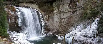
Transylvania County has over 250 waterfalls. Receiving over 90 inches of rain annually, it is the state's wettest county. (Buncombe County, 30 miles northeast, is the driest.) The Blue Ridge Parkway traverses parts of the county, and has views of the Appalachian Mountains, which reach over 6,000 feet (1,800 m) elevation in the county. The highest point, Chestnut Knob, 6,025 feet (1,836 m), lies northwest of Brevard.
Adjacent counties
- Henderson County - east
- Greenville County, South Carolina - southeast
- Pickens County, South Carolina - south
- Oconee County, South Carolina - southwest
- Jackson County - west
- Haywood County - northwest
- Buncombe County - northeast
National protected areas
- Blue Ridge Parkway (part)
- Pisgah National Forest (part)
Demographics
| Historical population | |||
|---|---|---|---|
| Census | Pop. | %± | |
| 1870 | 3,536 | — | |
| 1880 | 5,340 | 51.0% | |
| 1890 | 5,881 | 10.1% | |
| 1900 | 6,620 | 12.6% | |
| 1910 | 7,191 | 8.6% | |
| 1920 | 9,303 | 29.4% | |
| 1930 | 9,589 | 3.1% | |
| 1940 | 12,241 | 27.7% | |
| 1950 | 15,194 | 24.1% | |
| 1960 | 16,372 | 7.8% | |
| 1970 | 19,713 | 20.4% | |
| 1980 | 23,417 | 18.8% | |
| 1990 | 25,520 | 9.0% | |
| 2000 | 29,334 | 14.9% | |
| 2010 | 33,090 | 12.8% | |
| 2018 (est.) | 34,215 | [9] | 3.4% |
| U.S. Decennial Census[10] 1790-1960[11] 1900-1990[12] 1990-2000[13] 2010-2013[1] | |||
As of the census[14] of 2010, there were 33,090 people, 14,394 households, and 8,660 families residing in the county. The population density was 83 people per square mile (30/km2). There were 15,553 housing units at an average density of 41 per square mile (16/km2). The racial makeup of the county was 92.4% White, 3.9% Black or African American, 0.3% Native American, 0.4% Asian, and 1.12% from two or more races. 2.9% of the population were Hispanic or Latino of any race.
There were 12,320 households, out of which 25.10% had children under the age of 18 living with them, 58.60% were married couples living together, 8.70% had a female householder with no husband present, and 29.70% were non-families. 26.10% of all households were made up of individuals, and 12.40% had someone living alone who was 65 years of age or older. The average household size was 2.30 and the average family size was 2.74.
In the county, the population was spread out, with 20.40% under the age of 18, 8.20% from 18 to 24, 23.10% from 25 to 44, 26.90% from 45 to 64, and 21.40% who were 65 years of age or older. The median age was 44 years. For every 100 females there were 92.70 males. For every 100 females age 18 and over, there were 89.50 males.
The median income for a household in the county was $38,587, and the median income for a family was $45,579. Males had a median income of $31,743 versus $21,191 for females. The per capita income for the county was $20,767. About 6.60% of families and 9.50% of the population were below the poverty line, including 11.80% of those under age 18 and 7.00% of those age 65 or over.
Communities
City
- Brevard (county seat)
Town
Townships
- Boyd
- Brevard
- Cathey's Creek
- Dunn's Rock
- Eastatoe
- Gloucester
- Hogback
- Little River
Unincorporated communities
- Balsam Grove
- Cathey's Creek
- Cedar Mountain
- Connestee Falls
- Dunn's Rock
- Eastatoe
- Gloucester
- Lake Toxaway
- Little River
- Penrose
- Pisgah Forest
- Quebec
- Sapphire
Hospital
Transylvania Regional Hospital (TRH) was formed in 1933 with the mission to serve the community's health care needs. A 94-bed facility fully accredited by the Joint Commission on Accreditation of Healthcare Organizations (JCAHO), it offers comprehensive services through more than 120 active, consulting and courtesy physicians representing a full spectrum of specialties.
Politics, law and government
At present Transylvania is a solidly Republican county, although much less so than the vast majority of Appalachia. No Democratic presidential nominee has carried Transylvania County since Jimmy Carter did so in 1976.
| Year | Republican | Democratic | Third parties |
|---|---|---|---|
| 2020 | 57.0% 11,636 | 41.4% 8,444 | 1.6% 324 |
| 2016 | 58.9% 10,520 | 36.7% 6,558 | 4.4% 791 |
| 2012 | 57.5% 9,634 | 40.7% 6,826 | 1.8% 303 |
| 2008 | 55.6% 9,401 | 43.0% 7,275 | 1.4% 233 |
| 2004 | 60.2% 9,386 | 39.1% 6,097 | 0.7% 105 |
| 2000 | 63.4% 9,011 | 35.5% 5,044 | 1.2% 170 |
| 1996 | 52.3% 6,734 | 37.6% 4,842 | 10.1% 1,301 |
| 1992 | 45.6% 5,984 | 39.0% 5,120 | 15.5% 2,033 |
| 1988 | 61.9% 7,009 | 37.8% 4,280 | 0.4% 41 |
| 1984 | 64.9% 6,956 | 34.8% 3,733 | 0.3% 28 |
| 1980 | 52.6% 4,826 | 43.7% 4,008 | 3.7% 341 |
| 1976 | 46.5% 4,089 | 52.7% 4,636 | 0.8% 66 |
| 1972 | 69.7% 5,860 | 27.6% 2,321 | 2.7% 223 |
| 1968 | 46.9% 4,033 | 25.7% 2,210 | 27.5% 2,365 |
| 1964 | 44.2% 3,547 | 55.8% 4,483 | |
| 1960 | 55.5% 4,221 | 44.5% 3,388 | |
| 1956 | 53.2% 3,901 | 46.8% 3,435 | |
| 1952 | 52.6% 4,047 | 47.4% 3,641 | |
| 1948 | 46.4% 2,861 | 48.3% 2,975 | 5.3% 327 |
| 1944 | 42.7% 2,251 | 57.3% 3,019 | |
| 1940 | 37.9% 2,019 | 62.1% 3,312 | |
| 1936 | 41.3% 2,001 | 58.7% 2,845 | |
| 1932 | 39.6% 1,671 | 59.8% 2,523 | 0.5% 22 |
| 1928 | 55.7% 2,165 | 44.3% 1,722 | |
| 1924 | 50.2% 1,814 | 49.2% 1,776 | 0.6% 22 |
| 1920 | 52.1% 1,680 | 47.9% 1,542 | |
| 1916 | 50.6% 841 | 49.4% 821 | |
| 1912 | 8.4% 107 | 49.5% 631 | 42.2% 538 |
Transylvania County has a council-manager form of government, with a five-member Board of Commissioners elected at large. The Commissioners hire and supervise a separate County Manager. The current County Manager is Jaime Laughter. The current members of the Board of Commissioners are Mike Hawkins (chairman), Page Lemel (vice-chairman), Jason Chappell, David Guice, and Jake Dalton.
Transylvania County is a member of the Land-of-Sky Regional Council of governments.
The current mayor of Brevard is Jimmy Harris. The current mayor of Rosman is Brian Shelton.
Points of interest
- Biltmore Forest School, first school of forestry in North America
- Blue Ridge Community College, Transylvania campus
- Blue Ridge Parkway
- Brevard College
- Brevard Little Theater[16]
- Brevard Music Center
- DuPont State Forest
- Gorges State Park
- Lake Toxaway
- Looking Glass Falls
- Nantahala National Forest [17]
- Pisgah Astronomical Research Institute
- Pisgah National Forest
- Sliding Rock[16]
- Transylvania Arts Council[16]
- Transylvania County Schools[18]
- Whitewater Falls, highest waterfall in North Carolina
References
- "State & County QuickFacts".
- "Find a County". National Association of Counties. Retrieved June 7, 2011.
- du Toit, Threlkel, Brian, Susan. "1861-1911 Timeline". Transylvania Heritage Museum. Retrieved October 30, 2019.
- "Transylvania County Sesquicentennial Video". YouTube. 2011.
- "2010 Census Gazetteer Files". United States Census Bureau. August 22, 2012. Archived from the original on January 12, 2015. Retrieved January 20, 2015.
- "Feature Detail Report for: French Broad River". US Geological Survey. Retrieved October 31, 2019.
- Watson, Melissa (2011). Hiking Waterfalls in North Carolina: A Guide to the State's Best Waterfall Hikes. FalconGuides. pp. 80–84. ISBN 978-0762771509.
- Thomas, Bill (1998). The North Carolina Sierra Club's guide to the Jocassee Gorges: Horsepasture, Bearwallow, & Toxaway Region. pp. 5–8.
- "Population and Housing Unit Estimates". Retrieved July 24, 2018.
- "U.S. Decennial Census". United States Census Bureau. Retrieved January 20, 2015.
- "Historical Census Browser". University of Virginia Library. Retrieved January 20, 2015.
- Forstall, Richard L., ed. (March 27, 1995). "Population of Counties by Decennial Census: 1900 to 1990". United States Census Bureau. Retrieved January 20, 2015.
- "Census 2000 PHC-T-4. Ranking Tables for Counties: 1990 and 2000" (PDF). United States Census Bureau. April 2, 2001. Retrieved January 20, 2015.
- "U.S. Census website". United States Census Bureau. Retrieved January 31, 2008.
- Leip, David. "Dave Leip's Atlas of U.S. Presidential Elections". uselectionatlas.org. Retrieved March 17, 2018.
- "About Our County | Transylvania County". www.transylvaniacounty.org. Retrieved March 17, 2018.
- "» Outdoor adventure and recreation in Brevard WNC, Transylvania County the Land of waterfalls Visit Brevard NC". brevardnc.com. Retrieved March 17, 2018.
- "Transylvania County Schools / Homepage". www.tcsnc.org. Retrieved March 17, 2018.
External links
| Wikimedia Commons has media related to Transylvania County, North Carolina. |
- HendersonvilleNews.com - The Times-News Online
- Cradle of Forestry In America website
- Transylvania County government website
- Transylvania County Library
- Carolina Mountain Land Conservancy
- Waterfalls in Transylvania County
- NCGenWeb Transylvania County - free genealogy resources for the county
- - Free Insider Guide to Brevard and Transylvania County
Municipalities and communities of Transylvania County, North Carolina, United States | ||
|---|---|---|
| City | ||
| Town | ||
| Unincorporated communities | ||
| ||

| Authority control |
|---|